Report on Concepcion (Nicaragua) — April 1977
Natural Science Event Bulletin, vol. 2, no. 4 (April 1977)
Managing Editor: David Squires.
Concepcion (Nicaragua) Eruption on 4 April followed by weeks of frequent small ash explosions
Please cite this report as:
Global Volcanism Program, 1977. Report on Concepcion (Nicaragua) (Squires, D., ed.). Natural Science Event Bulletin, 2:4. Smithsonian Institution. https://doi.org/10.5479/si.GVP.NSEB197704-344120
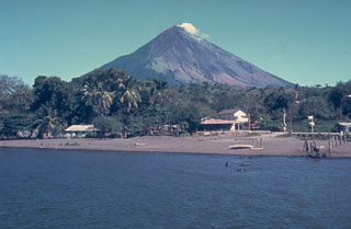
Concepcion
Nicaragua
11.538°N, 85.622°W; summit elev. 1700 m
All times are local (unless otherwise noted)
A 1-2-minute eruption from Concepción, which lit the sky "like daylight," began at 2326 on 4 April. Earthquakes were felt at about 1.5 hours and at 2 minutes prior to the eruption (2156 and 2324 on 4 April) and about 9 hours afterwards (0822 on 5 April). During the next several weeks, frequent small ash eruptions, separated by periods of gas emission, caused light ashfalls on Isla de Ometepe.
Sixteen separate explosions, some sending incandescent ash more than 1500 m above the summit, occurred between the early afternoon of 29 April and the morning of 1 May. A burst of seismicity accompanied each explosion. Ash fell intermittently at Rivas, 25 km SW of Concepción. A few minor ash clouds were reported on 3 May.
Local seismicity had begun to increase in October 1976 with many events occurring in December 1976 and March 1977. Between 1 and 27 April, 145 local earthquakes and many brief (a few seconds to a few minutes) periods of low-frequency tremors were recorded.
Geological Summary. Volcán Concepción is one of Nicaragua's highest and most active volcanoes. The symmetrical basaltic-to-dacitic stratovolcano forms the NW half of the dumbbell-shaped island of Ometepe in Lake Nicaragua and is connected to neighboring Madera volcano by a narrow isthmus. A steep-walled summit crater is 250 m deep and has a higher western rim. N-S-trending fractures on the flanks have produced chains of spatter cones, cinder cones, lava domes, and maars located on the NW, NE, SE, and southern sides extending in some cases down to Lake Nicaragua. Concepción was constructed above a basement of lake sediments, and the modern cone grew above a largely buried caldera, a small remnant of which forms a break in slope about halfway up the N flank. Frequent explosive eruptions during the past half century have increased the height of the summit significantly above that shown on current topographic maps and have kept the upper part of the volcano unvegetated.
Information Contacts: D. Harlow, USGS, Menlo Park, CA; A. Aburto Q., Instituto de Investigaciones Sísmicas.