Report on Kavachi (Solomon Islands) — July 1978
Scientific Event Alert Network Bulletin, vol. 3, no. 7 (July 1978)
Managing Editor: David Squires.
Kavachi (Solomon Islands) New island formed
Please cite this report as:
Global Volcanism Program, 1978. Report on Kavachi (Solomon Islands) (Squires, D., ed.). Scientific Event Alert Network Bulletin, 3:7. Smithsonian Institution. https://doi.org/10.5479/si.GVP.SEAN197807-255060
Kavachi
Solomon Islands
8.991°S, 157.979°E; summit elev. -20 m
All times are local (unless otherwise noted)
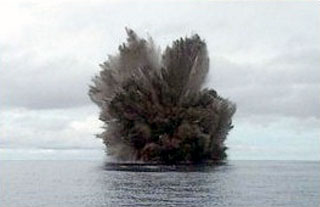
On 21 June, Bruce Kirkwood observed an eruption at Kavachi. Geologists from the Solomon Islands Ministry of Natural Resources flew over the site the next day and observed a circular island 30-50 m in diameter and 1-2 m in height (figure 4). Occasional weak explosions ejected ash and scoria, and the perimeter of the island was steaming.
 |
Figure 4. Airphoto taken 22 June 1978 showing the island formed by Kavachi's eruption. Courtesy of Frank Coulson. |
Kirkwood flew over the volcano again on 14 July and reported a N-S elongate island with a central cone estimated to be 30 m high. Bombs and blocks were thrown from the central vent to as much as 400 m altitude, and lava poured down the S flank. A small subsidiary vent appeared to be forming near sea level on the E coast.
By 16 July (Kirkwood's next overflight) the S half of the island, including the central vent, had dropped along an E-W fault with a scarp that formed the new S edge of the island. The subsided area appeared to be just below sea level and eruptive activity there continued. During the 10-minute overflight, 1 explosion was observed.
Geological Summary. Named for a sea-god of the Gatokae and Vangunu peoples, Kavachi is located in the Solomon Islands south of Vangunu Island. Sometimes referred to as Rejo te Kvachi ("Kavachi's Oven"), this shallow submarine basaltic-to-andesitic volcano has produced ephemeral islands up to 1 km long many times since its first recorded eruption during 1939. Residents of the nearby islands of Vanguna and Nggatokae (Gatokae) reported "fire on the water" prior to 1939, a possible reference to earlier eruptions. The roughly conical edifice rises from water depths of 1.1-1.2 km on the north and greater depths to the SE. Frequent shallow submarine and occasional subaerial eruptions produce phreatomagmatic explosions that eject steam, ash, and incandescent bombs. On a number of occasions lava flows were observed on the ephemeral islands.
Information Contacts: F. Coulson, Ministry of Natural Resources, Honiara.