Report on Shasta (United States) — August 1978
Scientific Event Alert Network Bulletin, vol. 3, no. 8 (August 1978)
Managing Editor: David Squires.
Shasta (United States) Earthquakes decline to few a day
Please cite this report as:
Global Volcanism Program, 1978. Report on Shasta (United States) (Squires, D., ed.). Scientific Event Alert Network Bulletin, 3:8. Smithsonian Institution. https://doi.org/10.5479/si.GVP.SEAN197808-323010
Shasta
United States
41.409°N, 122.193°W; summit elev. 4317 m
All times are local (unless otherwise noted)
The number of earthquakes declined to only a few events per day (M greater than or equal to 2) by 11 August. However, on 12 August a M 4.3-4.5 shock was followed by several similar events (approximately M 4), and others in the M 3.5-4 range occurred on the 13th. Activity then declined again; on 23 August only 13 events of M 2-2.5 were recorded, and by the end of August only about six events greater than M 2 were being recorded daily.
Epicenters have been located along about 2 km of a pre-existing N-S-trending fault zone 28 km E of the summit. Uncertain crustal velocities for the area have made depth determinations difficult, but all events have been shallow, probably less than 5 km, and some may have been less that 1 km deep. No migration of events has been observed. New tensional fissures have been found in the epicentral area, but were not growing as of late August. Leveling, microearthquake studies, and gravity profiles are planned.
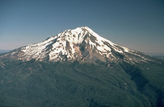
Geological Summary. The most voluminous of the Cascade volcanoes, northern California's Mount Shasta is a massive compound stratovolcano composed of at least four main edifices constructed over a period of at least 590,000 years. An older edifice was destroyed by a large debris avalanche which filled the Shasta River valley to the NW. The Hotlum cone, forming the present summit, the Shastina lava dome complex, and the SW flank Black Butte lava dome, were constructed during the early Holocene. Eruptions from these vents have produced pyroclastic flows and mudflows that affected areas as far as 20 km from the summit. Eruptions from Hotlum cone continued throughout the Holocene.
Information Contacts: R. Sherburne, California Division of Mines & Geology; A. Walter, USGS, Menlo Park, CA.