Report on Westdahl (United States) — September 1978
Scientific Event Alert Network Bulletin, vol. 3, no. 9 (September 1978)
Managing Editor: David Squires.
Westdahl (United States) February eruption site visited; new crater 1.5 km in diameter and 0.5 km deep
Please cite this report as:
Global Volcanism Program, 1978. Report on Westdahl (United States) (Squires, D., ed.). Scientific Event Alert Network Bulletin, 3:9. Smithsonian Institution. https://doi.org/10.5479/si.GVP.SEAN197809-311340
Westdahl
United States
54.516°N, 164.65°W; summit elev. 1563 m
All times are local (unless otherwise noted)
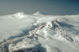
On 6-7 August a team of six, including volcanologists Maurice and Katia Krafft and Alain Gerente, climbed Westdahl. The new crater formed by the February eruption is about 1.5 km in diameter and 0.5 km deep, at about 1450 m elevation (figure 4). Its upper portion cut through glacial ice, which reached 200 m thickness on the N rim. The bottom of the vertical-walled crater is filled with blocks, ash, ice, and talus.
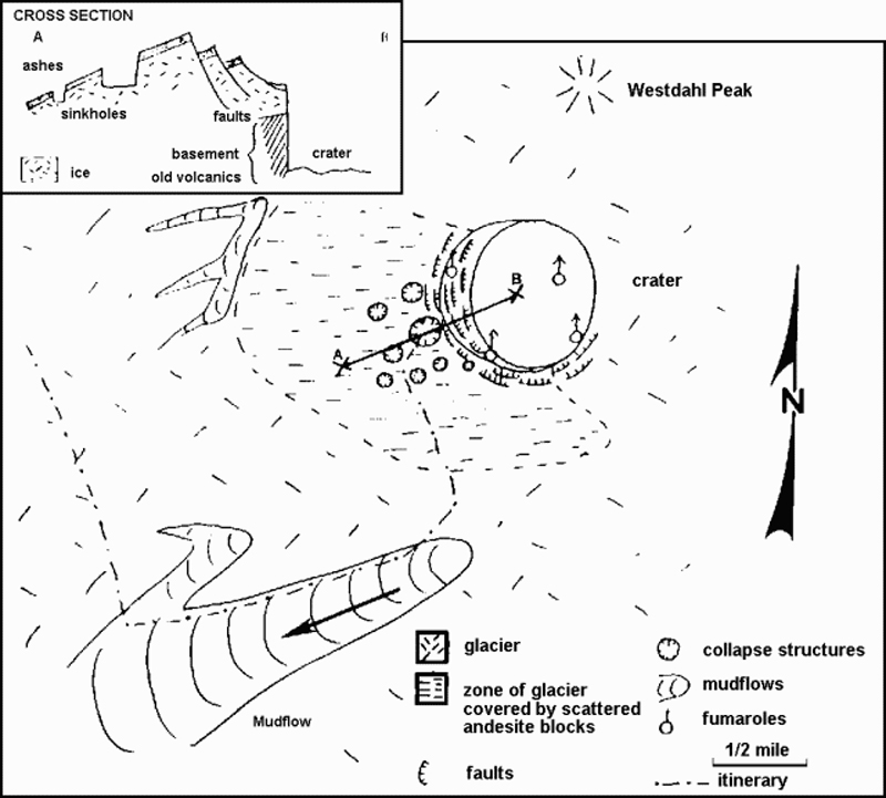 |
Figure 4. Sketch map with cross section of Westdahl's February eruption crater and vicinity, prepared by Maurice Krafft from observations made during a visit 6-7 August 1978. |
A lahar deposit, originating on the WSW flank of the new crater, extended down the glacier on Westdahl's flank to the sea, cutting the road from Cape Sarichef to Scotch Cap. The thickness of the upper portion of the deposit averaged about 50 cm, increasing to 1-3 m near the lower end.
A diary from Richard Clark (who was at Scotch Cap during the eruption) has established that the eruption began about 1330 on 4 February with the ejection of a steam cloud. Ash emission began soon afterward and ashfall started at Scotch Cap (15 km SW of the crater) at about 1600. A thunderstorm associated with the activity dropped hailstones formed around particles of ash and small lapilli. Tephra fall and the associated thunderstorm continued at Scotch Cap until mid-afternoon on 5 February. Clark reported that ash emission was continuing when he left the area during the morning of 8 February. A plume was visible in a satellite image at 1129 on 9 February (3:2). After the 9th, activity declined to steaming.
Geological Summary. Westdahl is a broad glacier-covered volcano occupying the SW end of Unimak Island. Two peaks protrude from the summit plateau, and a new crater formed in 1978 cuts the summit icecap. The volcano has a somewhat of a shield-like morphology and forms one of the largest volcanoes of the Aleutian Islands. The sharp-topped, conical Pogromni stratovolcano, 6 km N, rises several hundred meters higher than Westdahl, but is moderately glacially dissected and presumably older. Many satellitic cones of postglacial age are located along a NW-SE line cutting across the summit of Westdahl. Some of the historical eruptions attributed to the eroded Pogromni may have originated instead from Westdahl (Miller et al. 1998). The first historical eruption occurred in 1795. An 8-km-long fissure extending east from the summit produced explosive eruptions and lava flows in 1991.
Information Contacts: M. Krafft, Cernay; R. Clark, Blaine WA.