Report on St. Helens (United States) — May 1980

Scientific Event Alert Network Bulletin, vol. 5, no. 5 (May 1980)
Managing Editor: David Squires.
St. Helens (United States) Major eruption sends cloud to 23 km, destroys summit, and devastates region
Please cite this report as:
Global Volcanism Program, 1980. Report on St. Helens (United States) (Squires, D., ed.). Scientific Event Alert Network Bulletin, 5:5. Smithsonian Institution. https://doi.org/10.5479/si.GVP.SEAN198005-321050
St. Helens
United States
46.2°N, 122.18°W; summit elev. 2549 m
All times are local (unless otherwise noted)
A major eruption destroyed the summit of Mt. St. Helens, projected ash into the stratosphere, devastated the N and NW flanks, and killed dozens of people on 18 May. The initial explosion was heard more than 350 km away. Substantial ashfalls occurred hundreds of kilometers downwind, closing roads, schools, and businesses, and threatening crops in the NW USA.
Explosions similar to those of early to mid-April resumed [7] May and continued until 14 May. Several tens of earthquakes per day of M 3 or greater continued to be recorded through 17 May. Total seismic energy release remained relatively constant through late April, then declined slightly.
The USGS began daily [geodetic] measurements on the periphery of the N flank bulge on 25 April, recording consistent outward [displacement] of 1.5-2 m/day through 17 May (figure 5). The direction of movement was nearly horizontal, to the NNW.
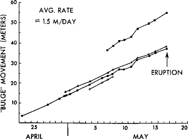 |
Figure 5. Cumulative outward movement of four different points on the N flank bulge of Mt. St. Helens, 23 April-18 May 1980. Courtesy of Robert Tilling. [Originally from SEAN 05:06.] |
18 May eruption. Much of the information on the 18 May eruption is from Robert Christiansen. His detailed narrative of the eruption will appear in the news section of Nature, [v. 285, p. 531-533.]
At 0832 on 18 May, seismographs recorded an earthquake of about M 5 (its unusual wave characteristics prevented a straightforward magnitude calculation). A remarkable series of photographs by Vern Hodgson shows the entire N-flank bulge immediately began to separate from the volcano along a fissure that opened across its upper section. The bulge quickly formed a massive avalanche that raced downslope, displaced the water of Spirit Lake, and struck a ridge about 8 km to the N. Most of the avalanche material then turned W and flowed down the N fork of the Toutle River (the outlet of Spirit Lake).
. . . The mudflows destroyed 123 homes and most of the bridges crossing the Toutle River for tens of kilometers downstream, then continued down the Cowlitz River into the Columbia, where suspended sediment, logs, and other debris filled the ship channel, stranding many vessels in Portland harbor.
A powerful laterally-directed blast emerged from the area formerly occupied by the bulge and overtook the avalanche within seconds. The blast, carrying lithic ash and lapilli, devastated a zone extending 30 km E-W and more than 20 km outward from the volcano in an arc encompassing almost 180° of the N flank (figure 6). Destruction was virtually total in an inner zone nearly 10 km wide, where no trees remained in the previously thickly-forested area. Beyond the inner zone, all trees were blown to the ground, pointing outward from the source of the blast in a nearly uniform radial pattern. In the outer few hundred meters of the blast area, trees were seared but remained standing.
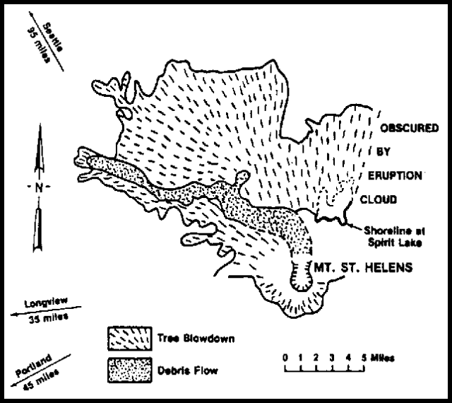 |
Figure 6. USGS sketch map of Mt. St. Helens. The area devastated by the 18 May 1980 directed blast is shown schematically by sketching radial tree blowdown. The deposit left by the avalanching N flank is stippled. |
Almost simultaneously with the ejection of the lateral blast, a large vertical cloud rose rapidly from the pre-existing summit crater to more than 19 km above sea level (as measured by Portland airport's weather radar), passing through an unusually high tropopause at 13.5-14 km (figure 7). Vigorous feeding of the vertical column continued for more than 9 hours, before declining gradually during the late afternoon. Ash clouds moved rapidly NE and E. Large quantities of ash fell on a wide area of Washington, N Idaho, and W and central Montana. Ashfall at Ritzville, Washington, more than 300 km from Mt. St. Helens, totaled at least 7 cm (figure 8). In Spokane, 500 km NE of the volcano, visibility was briefly reduced to only 3 m at about 1500. A trace of ash fell in Denver about noon the next day, and USGS hydrologists detected slight ashfall in parts of Oklahoma.
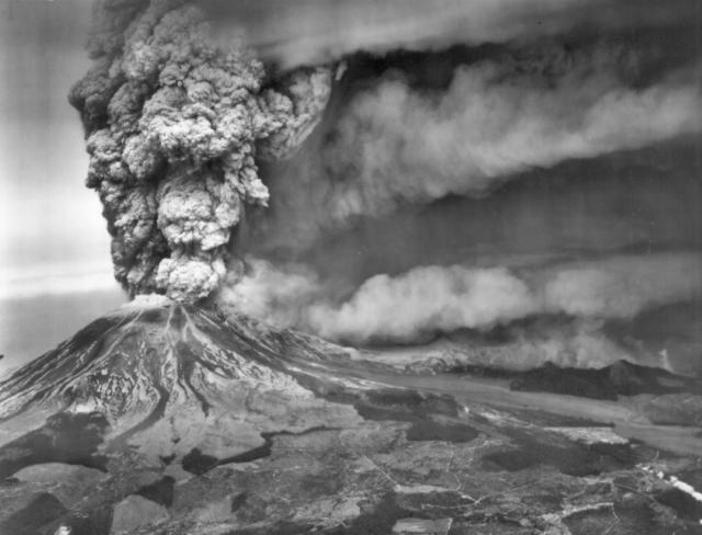 |
Figure 7. Oblique airphoto showing Mt. St. Helens erupting at about 1130 on 18 May 1980. View is approximately to the N. Courtesy of Austin Post, USGS. |
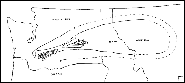 |
Figure 8. Isopach map of ashfall from the 18 May 1980 eruption of Mt. St. Helens, prepared from data provided by Albert Eggers and the USGS. Thicknesses are in centimeters. |
Pyroclastic flows, generated both by collapse of the vertical column and direct emission through the large northward breach produced by the directed blast, left a fan-shaped pumiceous deposit extending [into] Spirit Lake [and] the Toutle River, overlying debris flow deposits in that area.
Ash cloud. NOAA weather satellite imagery clearly recorded the rise and dissemination of ash clouds, and at least two distinct major pulses of ash ejection (figure 9). Measurements from the images showed that the cloud from the main explosion initially expanded in all directions, with the bulk of the ejecta moving E. [Measurements from satellite images indicated that the rate of horizontal advance of the cloud front averaged 250 km/hr for the first 13 minutes after the eruption's onset. Horizontal velocity soon decreased, remaining at about 100 km/hr for the first 1,000 km of its dispersal to the ENE.] Portland airport reported wind speeds of only 120 km/hr toward the E at 12 km altitude. The second pulse could be seen on the image returned at 1215. [From an aircraft, D. Swanson observed that] the color of the column [gradually] changed from dark gray to pale gray [between about 1200 and 1220].
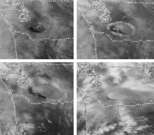 |
Figure 9. Mosaic of four images from NOAA's GOES West geostationary weather satellite, in orbit over the equator at 135°W. All of Washington and Oregon, most of Idaho and parts of Montana, California, Nevada and S Canada are shown. Image times (all 18 May 1980) are: upper left, 0845 (13 minutes after the eruption began), upper right, 0915, lower left, 0945, lower right, 1315. The first three images show the rapid dissemination of the Mt. St. Helens ash cloud after the initial explosion. The last image shows the eruption column from the second major burst, about 1 hour after it was ejected. Ash from earlier activity had spread to the Idaho-Montana border. Courtesy of Arthur Krueger and Andy Horvitz. |
Ash was widely dispersed in the atmosphere because of varying wind directions at different elevations (figure 10). Murray Mitchell reported that ash had made a complete circuit of the globe by 29 May. Most of the tropospheric material had fallen out by mid-June, but a diffuse dust veil remained in the stratosphere from the latitude of Mt. St. Helens N to the polar region. Bernard Mendonça reported that as of 9 June, NOAA's solar radiation and lidar equipment in Hawaii had detected no St. Helens ejecta. Seasonal arctic haze precluded observations from the Barrow, Alaska station. Stratospheric circulation patterns make aerosol movement to the S very unlikely before autumn.
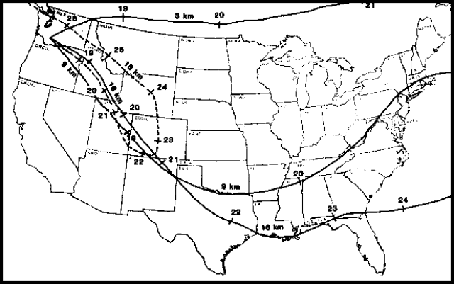 |
Figure 10. Paths traveled over North America by 18 May 1980 Mt. St. Helens ash at 3, 9, 16, and 18 km altitudes. Tick marks along each line show position of ash cloud front at that altitude every 24 hours, at noon GMT (0550 local time at Mt. St. Helens). The date at each tick mark is indicated. For clarity, the 18 km path is shown as a dashed line. The 21 May cloud from at 9 km altitude is just off the map to the E. Data provided by NOAA's Air Resources Laboratory. |
High-altitude studies of the eruption cloud were carried out using aircraft from several NASA installations, including the Ames and Langley research centers, LASL and NCAR. The pilot of the NASA Ames aircraft saw ash at nearly 23 km altitude while flying E of the volcano 18 May. NASA's SAGE satellite measured particle densities over S Canada on 22 May and the United States 23-27 May. "Ground truth" for the SAGE measurements was gathered by balloon from the University of Wyoming and other locations. Most data from these studies have not yet been analyzed. However, Grant Heiken reported that preliminary results from the LASL aircraft, sampling at about 15 km, show recovery of 1-11 µm particles (the bulk of which were 3-4 µm) that were virtually all glass shards. William Smith will gather a series of reports for the Upper Atmospheric Programs Bulletin, published jointly by the FAA and NASA.
Pollution-monitoring equipment operated by the Alexandria Virginia Health Department collected an unusual quantity of particulate matter (now being analyzed) during a rainstorm late 20 May. The 20 May rain was unusually acidic for that area, with a pH of 4-4.5, and occurred as Mt. St. Helens ash passed overhead.
Because of poor weather conditions, few brilliant sunrises or sunsets were reported in the United States after the 18 May eruption, although Grant Heiken was awakened by a gaudy, blood-red sunrise in Los Alamos, New Mexico. Charles Van Zant observed a ring around the sun from Cancún, Mexico (on the Yucatán Peninsula) at about noon on 23 May. The ring filled about 1/4 of the sky and was rainbow-colored at its edge.
Energetics. The acoustic pressure wave produced by the initial 18 May explosion was recorded on microbarographs operated by NOAA in Boulder, Colorado and Washington, DC, and on infrasound equipment operated by William Donn at the Lamont-Doherty Geological Observatory N of New York City. The waves recorded on these instruments were comparable to those generated by previous 10 megaton nuclear tests. Wave frequencies were very low, about 1 cycle per 5 minutes (0.003 Hz).
Morphologic changes. The [debris avalanche], lateral blast, and vertical explosion created a crater, breached to the N, with a N-S dimension of about 3 km and an E-W dimension of about 1.5 km (somewhat wider at the base of the breach). The summit was destroyed. The maximum elevation of the volcano, on the crater rim, was about 350 m less than the previous summit altitude of 2,975 m. The lower end of the breach extended downward nearly to the 1,500 m level.
Volume. Volume calculations for the eruption were very preliminary, based on the size of the new crater and the amount of ash deposited. Most estimates are in the 1-2 km3 range, but some are as high as 4 km3. Comparison with previous eruptions in the VRF indicated that explosions of this size occur only about once a decade.
Socioeconomic effects. At least 24 people are known to have been killed by the 18 May explosion, most by the avalanche and directed blast. Thirteen others known to have been in the area of maximum devastation at the time of the explosion are missing and presumed dead, including USGS geologist David Johnston (obituary at the end of this report). In addition, 37 persons believed to have been near the volcano on 18 May remain unaccounted for, bringing the probable death toll to 74. [Later estimates yield lower death tolls as the number of missing declined; the most recent data cited by Blong (1984) total 57 deaths.] State of Washington officials estimated the financial losses to private enterprise and state and local government to be at least $2.7 billion. [Blong (1984) tabulates about $1.5 billion in losses and cleanup costs.]
The following is from a report by R.J. Blong, who visited Yakima, Washington (140 km ENE of the volcano) 4 weeks after the 18 May explosion to study the socioeconomic effects of the tephra fall.
"Ashfall at Yakima from the 18 May eruption amounted to 12-18 mm. Automatic street lighting systems came on about 1115 and did not switch off until the following morning, although there was some lightening of the sky just before dusk. No deaths can be directly attributed to the ashfall. Two people died from cardio-pulmonary disease during the clean-up operation. Some people experienced headaches and gastroenteritis the day after exposure to the ash, the symptoms recurring in some of those involved in the cleanup. This may have been a stress reaction, but a virus with similar symptoms was prevalent in the area before the tephra fall. The cleanup operation created a great deal of camaraderie but some hostility developed where cars sped through streets stirring up the ash and where some roofs remained uncleaned. Anxiety but not depression developed.
"The Yakima airport and the airspace above was closed for 7 days. Twenty thousand tons of ash were removed from the 40 hectares of hard surface area by a team of up to 150 people working with 40 pieces of earthmoving equipment. The airport cleanup cost about $75,000 for equipment hire, labor (including overtime), and fuel.
"Pacific Power and Light experienced no problems meeting the peak demand when the darkness fell, probably because it was a warm day and a Sunday. Four or five older-style transformers caught fire. Subsequently, during a rainfall, several poles caught fire either as a result of lightning strikes or from shorting out by ash across contacts. Generally the wind removed the tephra from poles, insulators and transformers and there was less trouble than anticipated by the company.
"Pacific Northwest Bell telephone service experienced an unprecedented demand. The toll network was designed to handle with little delay the busiest days (Mothers Day and Christmas) but there were 70% more attempts to make calls than occurred on Mothers Day, the previous Sunday. The company also had to take steps to keep the tephra out of the electro-mechanical system. Maintenance on public phones has doubled since the tephra fall whereas no increase in maintenance has been necessary for semi-public phones.
"The cost of cleaning the ash from Yakima's approximately 350 km of streets has been estimated at $2-4 million. Downtown businesses suffered a serious loss of revenue through being closed for up to a week. The Greater Yakima Chamber of Commerce estimated on 30 May the cost of the ashfall at $95 million, of which equipment damage and automotive maintenance and repair amounted to $42 million. Motel occupancy rates were down from 80-90% to less than 50%. The tourist and convention industry will continue to suffer severely unless steps are taken to assure townsfolk and potential visitors alike that 20 years of Mt. St. Helens activity does not mean 20 years of 18 May and its aftermath."
Petrology. The following preliminary petrologic data are from William Melson.
"An early dark-colored and later light-colored tephra layer have been noted in airfall from the 18 May explosions (R. Kienle, personal communication). Near the volcano, the upper layer contains large essential ejecta of pumice. These products have been analyzed on the electron microprobe. Pumice from three separate localities provided by R. Kienle and Bruce Nolf have essentially identical compositions with the following average: SiO2 = 63.35, Al2O3 = 18.38, FeOT = 3.87, MgO = 1.83, CaO = 5.22, K2O = 2.01, Na2O = 4.31, TiO2 = 0.37, P2O5 = 0.09, Cl = 0.1-0.2, F and S < 0.05%. Analyses of glass inclusions in plagioclase typically have consistently low sums, averaging about 93%, suggesting about 7% dissolved H2O. Cl in these is typically around 0.15% and F and S less than 0.05%. The dominant phenocryst in the pumice is plagioclase (average An 47-70), which makes up about 35% by weight. Accessory phases, in order of abundance, are hornblende, hypersthene (Fs 35), and subequal amounts of titan-magnetite and ilmenite.
"Tephra from the lower dark layer of the 18 May explosion layer is similar in composition to the pre-18 May tephra, reflecting the presence of material derived largely from the explosive destruction of the central part of the cone. The upper, lighter-colored tephra contains much more pumiceous material, visible megascopically and revealed in bulk analyses, reflecting, finally, the breaching of hornblende hypersthene dacite magma. Bulk analyses of the light-colored tephra show an increasing concentration of glass with distance from the volcano.
"Pumiceous tephra from the 25 May explosion contains accessory augite, according to C. A. Hopson, a phase absent or extremely rare in the 18 May pumice. It appears that the explosions are successively tapping deeper, less water-rich portions of a zoned magma chamber."
Seismicity. Preliminary analysis of seismic and deformation data indicates that there was no immediate warning of the imminence of a large explosion. After the M 5.0 earthquake that apparently triggered the eruption, a brief period of harmonic tremor was recorded, followed by the absence of any earthquakes with magnitudes greater than 2 until about 1145. Seismic activity increased rapidly after 1145, and almost continuous M 3.5-4 seismicity was recorded from 1400 to 1630 at the USGS Newport Observatory. After 1630, seismicity declined.
Tilt. Records of the only surviving tiltmeter, on the S flank, show that rapid inflation began at the same time as the explosion at 0832. Rapid inflation lasted only 10 minutes, succeeded by deflation that continued until about 1630. Moderate inflation then began and has continued.
Post-18 May activity. Eruptive activity declined after 18 May, and by the 21st was limited to episodic ejections from the crater, mostly of vapor. Large fumaroles and secondary explosions were generated from the debris flow deposit, occasionally producing columns of material as high as 2 km. Between 19 and 24 May, only a few earthquakes with magnitudes greater than 3 were recorded, in contrast to the several tens of events that had occurred each day since late March (figure 11). However, harmonic tremor began during that period (exact date not [reported]).
 |
Figure 11. Number of seismic events per hour with magnitudes > 3.2, 20 March-28 May 1980 at Mt. St. Helens. Courtesy of Robert Tilling. |
At 0232 on 25 May the amplitude of harmonic tremor began to increase. Within minutes, an ash-rich eruption column had been seen from a surveillance aircraft. By 0245, NWS radar at Portland recorded the top of the column at nearly 14 km. A swarm of small earthquakes, centered about 8 km below the volcano, began at 0249 and continued at a rate of 1-2/hr.
The density of ash in the eruption column started to decrease within 5 minutes, and the height of the column was declining within the first hour. Winds were quite variable, but much of the ash blew toward the W half of the compass. By 0600, ash was falling in the Portland-Vancouver area (80 km SW). Ashfall darkened the early morning in the Kelso-Longview area (55 km W) and the ash cloud extended as far as the Olympic Peninsula of NW Washington. Heavy rain during the eruption mixed with the ash to drop mud on much of the affected region. Many airports were closed and ground travel was difficult.
By 0800, harmonic tremor amplitude had declined and the earthquake swarm had begun to subside. However, the eruption continued through most of the day, with the altitude of the top of the column ranging from 4 to 6 km. The eruption declined during the evening, and activity was limited to emission of steam clouds containing varying amounts of ash by 0100 the following morning.
Most of the tephra ejected 25 May was juvenile material. Some pyroclastic-flow deposits were emplaced on the N flank. H.H. Lamb's preliminary estimate for the total Dust Veil Index from the 18 and 25 May eruptions is 600-1500.
The ash content of the plume declined during the next several days, and by late 28 May, the plume was entirely composed of vapor. Small incandescent areas were seen on the crater floor during the night of 28-29 May and on several occasions thereafter. Careful inspection showed that the incandescence was caused by the heating of parts of the crater floor by venting gases, not the presence of magma at the surface. Vigorous steaming continued through early June, with vapor rising to about 3.5 km altitude. SO2 content of the plume continued to be an order of magnitude greater than before the 18 May eruption. An L-shaped lake about l km across was observed in the crater 10 June [but see SEAN 05:06], away from the area of active steam venting. Harmonic tremor continued, at varying amplitudes, through early June, but earthquake activity remained at very low levels.
At press time, a third large explosion occurred. An Eastern Airlines pilot observed the ejection of a dense ash column at 2045 on 12 June. The cloud blew S and SW, dropping marble-sized tephra on Cougar (18 km SW of the pre-18 May summit). Ashfall began in Portland (about 80 km SW) by 2300, and more than 0.5 cm accumulated. Portland airport radar recorded pulsating echoes to altitudes of 10.6 to nearly 17 km. New bursts of ash were observed at about 2-minute intervals from a USFS monitoring aircraft. An earthquake of about M 4.0 was recorded by University of Washington seismographs at 2110. About 1,500 people were evacuated, without injury, from a designated danger zone within about 30 km of the volcano. Ash and accompanying rain made roads in NW Oregon and SW Washington muddy and treacherous. Portland airport was closed. After this explosion, on 15 June, the presence of a growing lava dome in the center of the crater was confirmed by the USGS.
Historical activity. Mt. St. Helens was last active between 1831 and 1857, when a series of eruptions were separated by intervals of up to 7 years. Most were small explosive events, and none approached the size of the 18 May activity. Crandell and Mullineaux (1978) describe a 4,000-year old eruption, [considerably greater than] that of 18 May, in their definitive paper. Pyroclastic flows and mudflows extended more than 30 km down the Toutle River, and more than 20 cm of tephra fell tens of kilometers NE of the volcano.
Very few volcanologists throughout history have lost their lives by eruption, but last year Robin Cooke and Elias Ravian were killed at Karkar and now we must report the death of David Johnston at Mt. St. Helens. At the time of the 18 May eruption, Dave was monitoring the volcano from a position just 8 km NNW of the summit. No one knew better than Dave the risk involved in his St. Helens work, and no one contributed more to the understanding of this volcano's eruptive mechanisms. Although only 30 years old, his PhD work on St. Augustine, and subsequent work with the USGS had already established his position among the leading young volcanologists in the world. His enthusiasm and warmth will be missed at least as much as will his scientific strength.
Further Reference. Blong, R.J., 1984, Volcanic Hazards: A Sourcebook on the Effects of Eruptions: Academic Press, Sydney, 424 p. [See also references following SEAN 05:12.]
Geological Summary. Prior to 1980, Mount St. Helens was a conical volcano sometimes known as the Fujisan of America. During the 1980 eruption the upper 400 m of the summit was removed by slope failure, leaving a 2 x 3.5 km breached crater now partially filled by a lava dome. There have been nine major eruptive periods beginning about 40-50,000 years ago, and it has been the most active volcano in the Cascade Range during the Holocene. Prior to 2,200 years ago, tephra, lava domes, and pyroclastic flows were erupted, forming the older edifice, but few lava flows extended beyond the base of the volcano. The modern edifice consists of basaltic as well as andesitic and dacitic products from summit and flank vents. Eruptions in the 19th century originated from the Goat Rocks area on the N flank, and were witnessed by early settlers.
Information Contacts: R. Christiansen, USGS, Menlo Park, CA; R. Tilling, USGS, Reston, VA; D. Mullineaux, D. Crandell, USGS, Denver, CO; A. Krueger, NOAA/NESS; M.P. McCormick, NASA Langley Research Center; W.S. Smith, FAA; G. Heiken, LANL; M. Mitchell, NOAA, Silver Spring, MD; R. Dalton, Alexandria, VA Health Dept.; B. Mendonça, L. Machta, NOAA/ARL; W. Donn, Lamont-Doherty Geological Observatory; C. Hopson, Univ. of California, Santa Barbara; B. Nolf, Central Oregon Community College; R. Blong, MacQuarie Univ.; A. Eggers, Univ. of Puget Sound; D. Dzurisin, HVO, HI; H.H. Lamb, Univ. of East Anglia; W.G. Melson, SI; S. Malone, R. Crosson, E. Endo, Univ. of Washington; Newport Geophysical Observatory; C. Van Zant, Richardson, TX; UPI, New York Times.