Report on Hekla (Iceland) — August 1980
Scientific Event Alert Network Bulletin, vol. 5, no. 8 (August 1980)
Managing Editor: David Squires.
Hekla (Iceland) Large tephra cloud and lava flows
Please cite this report as:
Global Volcanism Program, 1980. Report on Hekla (Iceland) (Squires, D., ed.). Scientific Event Alert Network Bulletin, 5:8. Smithsonian Institution. https://doi.org/10.5479/si.GVP.SEAN198008-372070
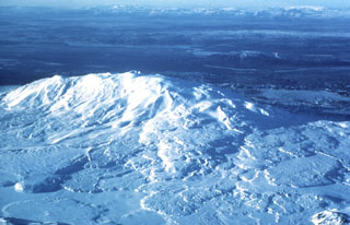
Hekla
Iceland
63.983°N, 19.666°W; summit elev. 1490 m
All times are local (unless otherwise noted)
"Hekla started erupting at 1328 on 17 August. Small earthquakes were recorded on local seismographs for 20-25 minutes prior to the first explosions but these precursors were not noticed until later.
"This was a mixed eruption starting in the summit area and quickly extending to the full fissure length of 7 km, longer than observed in the 1947 and 1970 eruptions. The initial activity at 1320 was a steam column, then a dark tephra column started between 1327 and 1330. The main tephra fall lasted about 2 hours and extended NNE, and the eruption column reached about 15 km altitude. The maximum tephra thickness 10 km N of the summit was 20 cm, and at the N coast, about 230 km distant, 1 mm or less. The fluorine content in many grazing districts is above danger level, causing problems for livestock, especially sheep. Lava began flowing shortly after the beginning of the eruption. The first flows appeared near the summit, then lava eruption extended to the lower parts of the fissure. Most of the lava issued within 12 hours and nearly all within 24 hours, forming four main separate lava flows, covering an area of about 22 km2. The volume of the lava is estimated at about 0.1 km2 and the tephra somewhat less than in the 1970 eruption, which produced 0.07 km3.
"Glowing scoria was last observed in the early morning of 20 August. Steam emission was continuing as of late August. For the first few days following the eruption this steam column was often darkened at the base, but no glow was observed.
"Preliminary chemical analyses of tephra and lava show composition similar to that of the 1970 eruption products. The last Hekla eruption took place 5 May-5 July 1970, making this period of quiescence of only 10 years the shortest recorded for Hekla since 1104. The shortest previous period between eruptions was 1206-22 and the second shortest was between the 1947 and 1970 eruptions. If the present eruption episode is over now, the behavior is highly unusual. All previous known eruptions have lasted from 2 months to 2 years. Initially there have been a few days of major activity, followed by a few almost quiet days, then renewed explosive activity and lava eruption concentrated on small parts of the fissure."
Geological Summary. One of Iceland's most prominent and active volcanoes, Hekla lies near the southern end of the eastern rift zone. Hekla occupies a rift-transform junction, and has produced basaltic andesites, in contrast to the tholeiitic basalts typical of Icelandic rift zone volcanoes. Vatnafjöll, a 40-km-long, 9-km-wide group of basaltic fissures and crater rows immediately SE of Hekla forms a part of the Hekla-Vatnafjöll volcanic system. A 5.5-km-long fissure, Heklugjá, cuts across the 1491-m-high Hekla volcano and is often active along its full length during major eruptions. Repeated eruptions along this rift, which is oblique to most rifting structures in the eastern volcanic zone, are responsible for Hekla's elongated ENE-WSW profile. Frequent large silicic explosive eruptions during historical time have deposited tephra throughout Iceland, providing valuable time markers used to date eruptions from other Icelandic volcanoes. Hekla tephras are generally rich in fluorine and are consequently very hazardous to grazing animals. Extensive lava flows from historical eruptions, which date back to 1104 CE, cover much of the volcano's flanks.
Information Contacts: K. Grönvold, Nordic Volcanological Institute (NVI); S. Thorarinsson, Univ. of Iceland.