Report on Kuchinoerabujima (Japan) — December 1980

Scientific Event Alert Network Bulletin, vol. 5, no. 12 (December 1980)
Managing Editor: David Squires.
Kuchinoerabujima (Japan) Seismicity and steaming decline; 28 September eruption fissure and tephra described
Please cite this report as:
Global Volcanism Program, 1980. Report on Kuchinoerabujima (Japan) (Squires, D., ed.). Scientific Event Alert Network Bulletin, 5:12. Smithsonian Institution. https://doi.org/10.5479/si.GVP.SEAN198012-282050
Kuchinoerabujima
Japan
30.443°N, 130.217°E; summit elev. 657 m
All times are local (unless otherwise noted)
"After the 28 September eruption, which lasted for 1/2 hour, no additional eruptions had occurred as of the end of December. Eight scientists from Kyoto University, Kagoshima University, and the JMA observatory arrived at the island on 1 October, installing portable seismometers at five sites. The next day, they climbed to the new fissure, which was 0.6-6.0 m wide and 750 m long, trending N-S near Shin-dake crater (figure 1), active in historic time. A considerable amount of white vapor was emitted from the fissure.
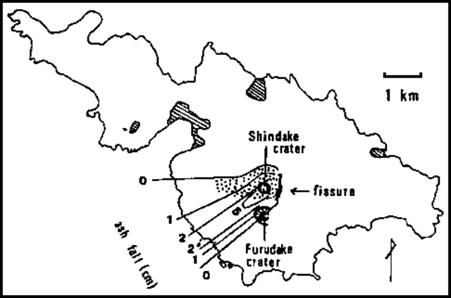 |
Figure 1. Sketch map of Kuchinoerabu-jima Island, 28 September 1980. Ashfall isopachs are in centimeters. Blocks fell in the stippled area. Shaded zones are inhabited. Courtesy of JMA. |
"The SW sector of the volcano was covered with gray ash, l m thick near the fissure and 2 cm thick at the base of the volcano, on the coast. Blocks were scattered N and W of the fissure, the largest block measuring about 2 m in diameter. No essential ejecta were observed. The volume of ejecta was estimated at about 105 m3. Steaming decreased gradually during October, and was restricted to 10 small craters on the fissure by mid-October.
"Seismicity was relatively weak in October and November except on 4 and 9 October when swarms of small B-type earthquakes were recorded (figure 2). The JMA's seismometer was removed on 15 November because the volcano was quiet. People on the island reported no felt earthquakes, and decreasing steam activity through December. Life returned to normal for the island's 300 inhabitants soon after the 28 September eruption."
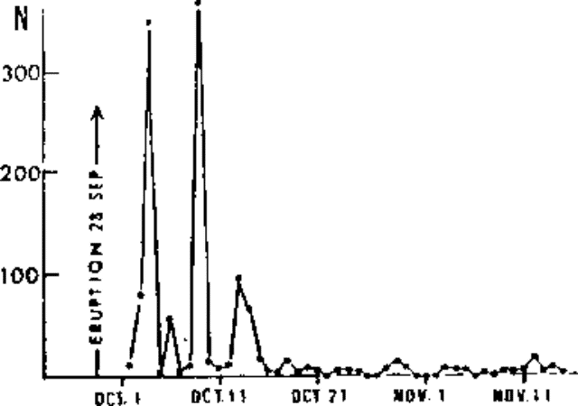 |
Figure 2. Number of seismic events/day at Kuchinoerabu-jima, 1 October-15 November 1980. Courtesy of JMA. |
Geological Summary. A group of young stratovolcanoes forms the eastern end of the irregularly shaped island of Kuchinoerabujima in the northern Ryukyu Islands, 15 km W of Yakushima. The Furudake, Shindake, and Noikeyama cones were erupted from south to north, respectively, forming a composite cone with multiple craters. All historical eruptions have occurred from Shindake, although a lava flow from the S flank of Furudake that reached the coast has a very fresh morphology. Frequent explosive eruptions have taken place from Shindake since 1840; the largest of these was in December 1933. Several villages on the 4 x 12 km island are located within a few kilometers of the active crater and have suffered damage from eruptions.
Information Contacts: JMA, Tokyo.