Report on Alaid (Russia) — April 1981
Scientific Event Alert Network Bulletin, vol. 6, no. 4 (April 1981)
Managing Editor: Lindsay McClelland.
Alaid (Russia) Strong explosive eruption; ashfalls to more than 1,000 km
Please cite this report as:
Global Volcanism Program, 1981. Report on Alaid (Russia) (McClelland, L., ed.). Scientific Event Alert Network Bulletin, 6:4. Smithsonian Institution. https://doi.org/10.5479/si.GVP.SEAN198104-290390
Alaid
Russia
50.861°N, 155.565°E; summit elev. 2285 m
All times are local (unless otherwise noted)
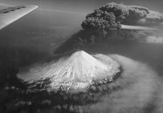
Soviet volcanologists reported that an explosive summit eruption from Alaid, on uninhabited Atlasova Island, began after midday on 27 April and intensified the next day. Much of the information on the eruption from both U.S. and Soviet sources is from analysis of satellite imagery. Clouds prevented satellite observations until about 0715 on the 28th, when infrared imagery from the NOAA 6 polar orbiter revealed a distinct V-shaped eruption plume that extended a short distance NE from the volcano before disappearing in heavy weather clouds. An infrared image returned from the GMS at 1100 showed a similar pattern. Microbarographs at Kushiro Weather Observatory (about 1,250 km SW of Alaid) recorded three distinct pressure waves on 28 April: at 1143 (0.5 millibars), 1153 (0.2 millibars), and 1340 (0.8 millibars).
Vigorous feeding of this cloud could be seen on the satellite imagery for the next 2 days (figure 1). 29 April imagery indicated that the plume consisted of two primary layers, at about 9-11 km and 13.5-15 km altitude. The last clear-weather image, on 30 April at 1700, showed a plume at least 120 km wide and 1,900 km long. Eighteen hours later (1100 on 1 May, 4 days after the eruption began) partial clearing showed that feeding of the plume had apparently ended. Weather obscured the area on images from 30 April at 2300 to 1 May at 1100, when partial clearing showed that feeding of the plume had apparently ended.
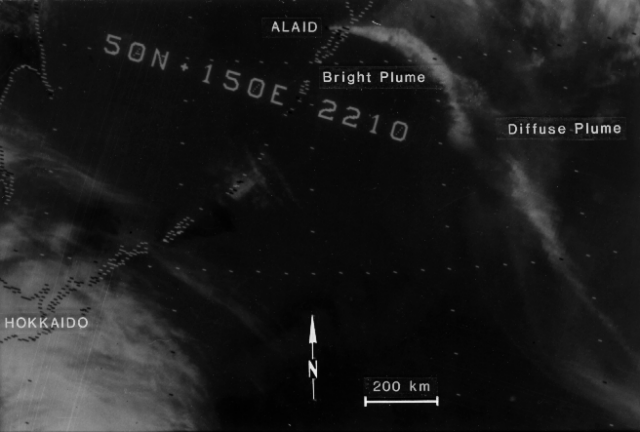 |
Figure 1. NOAA 6 satellite image, returned 30 April at 0910, showing eruption plumes from Alaid. The image was obtained using the 11 µm thermal infrared sensor. Image resolution is 4 km. Two plumes are evident, one bright and distinct. the other diffuse, but well-defined. The plumes are over 1,700 km in length, trailing off the right side of the image. Analysis of the imagery shows that the brighter plume has a temperature of about -55°C, and the diffuse plume an apparent temperature of -10°C. Comparison of the temperature of the colder (and therefore higher) of the two plumes with radiosonde temperature profiles collected from Petropavlovsk. Kamchatka (300 km NE of the volcano) and Podgornoye, Paramushir Island (50 km S of the volcano) yielded two possible altitudes for this plume; 9.8-10.4 km if it had not passed through the tropopause (at 11.6 km), or 13.7-14.3 km if the plume was stratospheric. The image and caption information were provided by Michael Matson. |
Significant ashfalls were reported over a wide area. Soviet volcanologists reported that the ash, a pyroxene olivine basalt, fell as much as 1,000 km from the volcano, over an area of 150,000 km2. They noted an accumulation of 30 cm of ash 7 km from Alaid, and Tass reported that 20-25 cm fell on the town of Severokurilsk (45 km ESE of the volcano), where residents heard roaring noises and saw a glow from the volcano during the night. Schools were closed in Severokurilsk and radio communication was disrupted. Ash mixed with wet snow fell on Petropavlovsk (300 km NE of the volcano) and other inhabited areas on the Kamchatka Peninsula. In the Aleutians, ashfall began 28 April on Shemya (about 1,200 km ENE of Alaid), and lasted all day 30 April and 1 May, when roughly 2 mm of ash were measured in very windy weather. Lt. Becker observed intermittent ashfalls and periods of acid rain between 2 and 5 May, always within 1.5 hours after low ocean tide. Ash collected at Shemya was sent to the NASA Ames Research Center. Daily precipitation sampling from Adak Island (650 km E of Shemya and 1900 km from Alaid) 1-7 May yielded only a trace of ash, on the 4th.
Tass reported that volcanologists overflew the volcano 29 April and observed an ash column that rose to about 10 km altitude from the summit crater. Soviet volcanologists later reported a maximum eruption cloud height during the activity of 12 km, based on overflights and analysis of satellite imagery.
Soviet volcanologists reported that activity declined 2-4 May. No additional activity was observed on satellite imagery until 8 May at 2300, when the GMS satellite recorded a new eruption column starting to emerge from Alaid. Careful examination of earlier imagery from other satellites indicates that the renewed activity may have started as early as 1930. By 9 May at 0300, a dense plume extended more than 120 km to the ESE. This plume remained shorter and much narrower than the late April clouds, reaching a maximum length of about 400 km ESE from the volcano. GMS imagery continued to show strong feeding of the cloud at 1100, but the eruption seemed to be weakening by 1400 and had apparently ended by the time of the next available image at 2000.
Attempts to observe and sample the ejecta farther downwind continue. During the night of 6-7 May, lidar operated by SRI International near San Francisco, California detected two distinct layers of material at 11.9 and 12.8 km altitude, just below the tropopause. However, it was not possible to confirm that this material was of volcanic origin.
A preliminary search for strong seismicity associated with the eruption yielded only a single shallow magnitude 6.0 event at 44.04°N, 149.93°E (860 km SSW of the volcano), on 1 May at 0142.
Geological Summary. The highest and northernmost volcano of the Kuril Islands, Alaid is a symmetrical stratovolcano when viewed from the north, but has a 1.5-km-wide summit crater that is breached open to the south. This basaltic to basaltic andesite volcano is the northernmost of a chain constructed west of the main Kuril archipelago. Numerous pyroclastic cones are present the lower flanks, particularly on the NW and SE sides, including an offshore cone formed during the 1933-34 eruption. Strong explosive eruptions have occurred from the summit crater beginning in the 18th century. Reports of eruptions in 1770, 1789, 1821, 1829, 1843, 1848, and 1858 were considered incorrect by Gorshkov (1970). Explosive eruptions in 1790 and 1981 were among the largest reported in the Kuril Islands.
Information Contacts: S. Fedotov and B. Ivanov, IVP; F. Smigielski, S. Arnett, and M. Matson, NOAA/NESS; G. Telegadas, NOAA/ARL; D. Shimozuru, Univ. of Tokyo; R. Muñoz, NASA, Ames Research Center; M. McCormick, NASA, Langley Research Center; P. Russell, SRI International; Lt. Becker, USAF, Shemya AK; Tass; USGS/NEIS.