Report on Hekla (Iceland) — April 1981
Scientific Event Alert Network Bulletin, vol. 6, no. 4 (April 1981)
Managing Editor: Lindsay McClelland.
Hekla (Iceland) Lava extrusion and ash ejection from summit crater
Please cite this report as:
Global Volcanism Program, 1981. Report on Hekla (Iceland) (McClelland, L., ed.). Scientific Event Alert Network Bulletin, 6:4. Smithsonian Institution. https://doi.org/10.5479/si.GVP.SEAN198104-372070
Hekla
Iceland
63.983°N, 19.666°W; summit elev. 1490 m
All times are local (unless otherwise noted)
[The report in 6:4 repeats and expands upon the preliminary information received at press time for 6:3. These reports are combined here.]
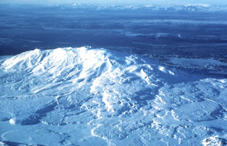
An eruption of Hekla was first observed about 0300 on 9 April. The initial activity consisted of ejection of ash columns. Pilots said that ash reached 4.2 km altitude and radar registered the top of an eruption column at 6.6 km above sea level. Ash was blown N, toward the interior of Iceland, falling at least 30 km from the volcano. Lava extrusion from a newly formed summit crater began later on 9 April, reached a peak during the afternoon, then declined gradually until the eruption ended on 16 April. Three flows were extruded, the two largest moving down the N side of the main Hekla ridge, the smallest down the S side. The lava covered an area of 5-6 km2 and extended a maximum of 4.5 km from the crater, reaching the base of Hekla Ridge on both the N and S sides. After the initial ash ejection, activity was dominantly effusive, but a small amount of ash fell E and NE of the volcano later in the eruption. The area has remained inaccessible, but ash amounts were estimated to be only a few millimeters thick. No earthquakes were recorded prior to the eruption, and distinct harmonic tremor did not appear on seismic records until after the eruption began.
Volcanologists interpreted the April activity as a continuation of the much larger eruption of August 1980.
Further Reference. Grönvold, K., Larsen, G., Einarsson, P., Thorarinsson, S., and others, 1983, The Hekla eruption of 1980-1981: BV, v. 46, p. 349-364.
Geological Summary. One of Iceland's most prominent and active volcanoes, Hekla lies near the southern end of the eastern rift zone. Hekla occupies a rift-transform junction, and has produced basaltic andesites, in contrast to the tholeiitic basalts typical of Icelandic rift zone volcanoes. Vatnafjöll, a 40-km-long, 9-km-wide group of basaltic fissures and crater rows immediately SE of Hekla forms a part of the Hekla-Vatnafjöll volcanic system. A 5.5-km-long fissure, Heklugjá, cuts across the 1491-m-high Hekla volcano and is often active along its full length during major eruptions. Repeated eruptions along this rift, which is oblique to most rifting structures in the eastern volcanic zone, are responsible for Hekla's elongated ENE-WSW profile. Frequent large silicic explosive eruptions during historical time have deposited tephra throughout Iceland, providing valuable time markers used to date eruptions from other Icelandic volcanoes. Hekla tephras are generally rich in fluorine and are consequently very hazardous to grazing animals. Extensive lava flows from historical eruptions, which date back to 1104 CE, cover much of the volcano's flanks.
Information Contacts: K. Gronvold, NVI; S. Thorarinsson, Univ. of Iceland.