Report on St. Helens (United States) — October 1981

Scientific Event Alert Network Bulletin, vol. 6, no. 10 (October 1981)
Managing Editor: Lindsay McClelland.
St. Helens (United States) Lava extrusion adds new lobe to composite dome
Please cite this report as:
Global Volcanism Program, 1981. Report on St. Helens (United States) (McClelland, L., ed.). Scientific Event Alert Network Bulletin, 6:10. Smithsonian Institution. https://doi.org/10.5479/si.GVP.SEAN198110-321050
St. Helens
United States
46.2°N, 122.18°W; summit elev. 2549 m
All times are local (unless otherwise noted)
Lava extrusion that probably began 30 October added a new lobe to the composite dome in the crater, the 9th extrusive episode since the catastrophic eruption of 18 May 1980. After lava extrusion ended 10 September (SEAN 06:08), rates of displacement in the crater remained low for several weeks, as they had after earlier extrusion episodes. Sulfur dioxide emission ranged from 70 to 190 t/d 9-24 October, but showed no particular trends.
The crater floor was not quiet during this period. Inflation of the dome has caused small thrust faults to form in the surrounding crater floor. In early October, the most active thrust, S of the dome, was moving at about 1.5 cm/day, and stations on the N crater rampart showed outward movement of about 0.5 cm/day. By 24 October, these rates had increased to 14.5 and 3.5-4 cm/day respectively, and levelling profiles perpendicular to the dome showed that crater floor tilt rates had reached 400-500 µrad/day, prompting the USGS to issue an advisory prediction of renewed lava extrusion within the next 2 weeks.
Eleven laser targets were installed on the dome and distances to the targets were measured from fixed points 150-1,000 m away beginning 21-23 October. Rates of lateral expansion of the dome varied considerably, but were as much as 50 cm/day as of 25 October. Three continuously recording tiltmeters located 550, 850, and 1,050 m N of the center of the dome began returning data 13 October. No significant tilt was detected by these instruments until about noon on 26 October, when all three began to record inflation at 25-50 µrad/day. The number of local earthquakes began to increase on 27 October, and gradually became more frequent through the 29th, but most of the events were extremely small. Seismicity increased substantially between midnight and 0700 on 30 October, then all but rockfall events ceased fairly abruptly shortly after 0730. During this period, there were a few events that reached roughly M 1, but none were in the M 1.5-1.8 range typical of the larger events prior to past additions to the dome, and the total seismic energy release was much smaller than that associated with previous extrusion episodes. Inflation registered by the three continuously recording tiltmeters N of the dome flattened out on 29 October and at least one instrument began to show deflation by 0800 on the 30th.
Poor weather prevented any observations of the crater 30 October. When visibility improved early on the 31st, a substantial quantity of lava had already been extruded from the N part of the pre-existing dome's summit area. The new lobe advanced gradually down the N flank over portions of lobes extruded in April, June, and September. Geologists in the crater 31 October noted that several plastic airphoto targets N of the dome had melted and some metal fenceposts had been bent, although boards on the ground were not disturbed, indicating that a directed hot blast may have moved 200-300 m N from the dome. By the evening of 1 November, the new lava had advanced about halfway down the dome's N flank (figure 19), but was moving more slowly than the previous day. The lobe front moved roughly 20-40 m downslope during the next 24 hours, a quarter to half of the previous rate of advance. As of late 4 November, lava had nearly reached the foot of the April lobe, where a substantial pile of talus had accumulated, and appeared to be advancing slowly, but lava extrusion had stopped by 5 November. The volume of the new lobe appeared to be roughly comparable to that of previous lobes (a few million cubic meters).
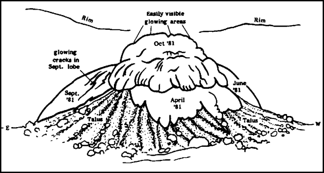 |
Figure 19. Sketch of the N side of the Mt. St. Helens composite dome at 1400 on 1 November 1981, looking S from the mouth of the crater. Sketch by Bobbie Myers. |
The extrusion was accompanied by major deformation of the dome, particularly at the S end, where dramatic changes took place. Large blocks were thrust upwards 10-20 m and steep outward tilting was obvious. On 31 October, the four remaining laser targets on the dome showed outward movements of 1-8.2 m since the previous measurements six days earlier. However, by 2 November, expansion of the pre-existing dome had slowed to only a few centimeters per day and some areas may have been showing subsidence. Large incandescent cracks radial to the center of the new extrusion extended from top to bottom of the September lobe, and the June lobe also showed large new cracks. As during previous extrusion episodes, thrust faults stopped moving (on 1 November) and significant deformation of the crater floor had not resumed as of 10 November. SO2 emission during the extrusion peaked at 220 t/d (on 31 October) then dropped steadily, to 160 t/d 3 November, 130 t/d on the 6th, and 80 t/d on the 10th.
Geological Summary. Prior to 1980, Mount St. Helens was a conical volcano sometimes known as the Fujisan of America. During the 1980 eruption the upper 400 m of the summit was removed by slope failure, leaving a 2 x 3.5 km breached crater now partially filled by a lava dome. There have been nine major eruptive periods beginning about 40-50,000 years ago, and it has been the most active volcano in the Cascade Range during the Holocene. Prior to 2,200 years ago, tephra, lava domes, and pyroclastic flows were erupted, forming the older edifice, but few lava flows extended beyond the base of the volcano. The modern edifice consists of basaltic as well as andesitic and dacitic products from summit and flank vents. Eruptions in the 19th century originated from the Goat Rocks area on the N flank, and were witnessed by early settlers.
Information Contacts: T. Casadevall, D. Dzurisin, D. Peterson, D. Swanson, USGS, Vancouver, WA; C. Boyko, S. Malone, E. Endo, C. Weaver, University of Washington; R. Tilling, USGS, Reston, VA.