Report on Mehetia (France) — October 1981
Scientific Event Alert Network Bulletin, vol. 6, no. 10 (October 1981)
Managing Editor: Lindsay McClelland.
Mehetia (France) Several months of increased seismicity
Please cite this report as:
Global Volcanism Program, 1981. Report on Mehetia (France) (McClelland, L., ed.). Scientific Event Alert Network Bulletin, 6:10. Smithsonian Institution. https://doi.org/10.5479/si.GVP.SEAN198110-333040
Mehetia
France
17.874°S, 148.068°W; summit elev. 389 m
All times are local (unless otherwise noted)
A swarm of earthquakes centered beneath Mehetia began suddenly on 6 March and was continuing in late October. After the first two days of the swarm, characterized by numerous weak events, seismographs began to record occasional larger shocks (figure 1). The seismic energy released during the first week of the swarm greatly exceeded the previous total energy release detected by the Tahitian seismic net since the first stations were installed in 1962-63. Both the number of earthquakes (figure 2) and energy release (figure 3) varied considerably, with periods of increased activity separated by brief lulls. Epicenters were about 10 km SE of the crater. There were several groups of foci, which may indicate vertical migration, but it was impossible to compute depths of focus for most of the events. A temporary seismic station operated on Mehetia 25-30 March recorded local earthquakes at about 13 km depth.
 |
Figure 1. Log plot of number of events vs. magnitude at intervals of ML 0.2 recorded from Mehetia, 6 March-15 December 1981. The b value (slope) of the regression line is 1.13 ± 0.03 for the entire swarm. For the first two days of the swarm, characterized by numerous weak events, b = 1.63. Courtesy of J. Talandier. |
 |
Figure 2. Number of recorded earthquakes (ML 0.9 or greater) per day (3-day means) at Mehetia, 6 March-early December 1981 (293 days). The total number of such events during this interval was 3,536. The Tahitian seismic net records most local events of ML 1.1 or greater, but fluctuating levels of microseismic noise prevent consistent recording of weaker events. Courtesy of J. Talandier. |
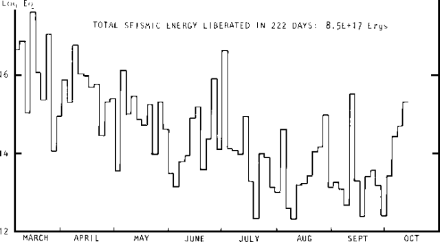 |
Figure 3. Seismic energy released by the Mehetia swarm (3-day intervals), 6 March-early December 1981. Courtesy of J. Talandier. |
By late October, more than 3,000 local events of magnitude 0.9 (ML) or stronger had been recorded. Of these, about 30 were stronger than ML 3.0, including magnitude 4.0 and 4.3 shocks. Because of the detection limits (usually about ML 1.1, but weaker seismicity is sometimes recorded during periods of lesser microseismic noise) for events in the Mehetia area (~140 km from the nearest Tahitian net station), harmonic tremor, if any, would probably not be recorded. Talandier's extrapolation of the well-defined frequency-magnitude relationship indicates that about 50,000 events stronger than ML 0.1 have probably occurred during the swarm. Talandier also notes that the Mehetia swarm and seismicity associated with Hawaiian volcanoes showed similarities in number and magnitude of events and seismogram characteristics, as well as the detection of long-period waves that could be generated by events occurring beneath a magma chamber. No surface volcanic activity has been reported at Mehetia. The island is uninhabited, working conditions there are difficult, and no geologist has visited the area recently.
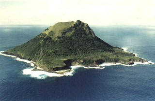
Mehetia is a well-defined cone about 1,500 m in diameter and 435 m high, with a 200-m-diameter crater at the summit. No historic eruptions have been reported, but the limited erosion of the crater and flanks, lack of vegetation at the summit, and Tahitian legends of "big fires" all indicate that eruptions probably took place less than 2,000 years ago.
Geological Summary. The 1.5-km-wide, steep-sided island of Mehetia (known as Meetia or Meketia in the Tahitian and Tuamotuan languages, respectively), the youngest and SE-most of the Society Islands, lacks a well-developed fringing coral reef. The ~400-m-high island is the summit of a large volcano that rises 4,000 m from the sea floor. An older edifice is formed of a lava flow sequence overlain by hydromagmatic deposits and Strombolian ejecta. The summit crater, 150 m wide and 80 m deep, has been the source of the youngest lava flows on the island (Binard et al., 1993). Polynesian legends mention "large fires," and the lack of vegetation on some lava flows suggests that the latest activity occurred within the last 2,000 years (Talandier and Custer, 1976). Other recent activity originated from a submarine crater at 2,500-2,700 m depth on the SE flank.
Information Contacts: J.M. Talandier, Lab. de Géophysique, Tahiti.