Report on Krafla (Iceland) — November 1981

Scientific Event Alert Network Bulletin, vol. 6, no. 11 (November 1981)
Managing Editor: Lindsay McClelland.
Krafla (Iceland) Fissure eruption
Please cite this report as:
Global Volcanism Program, 1981. Report on Krafla (Iceland) (McClelland, L., ed.). Scientific Event Alert Network Bulletin, 6:11. Smithsonian Institution. https://doi.org/10.5479/si.GVP.SEAN198111-373080
Krafla
Iceland
65.715°N, 16.728°W; summit elev. 800 m
All times are local (unless otherwise noted)
"The 30 January-4 February eruption (6:1-2) was followed by a rapid recovery of land elevation. Tiltmeters indicated that previous land levels had been reached by the end of March. After that the rate of tilt change was very slow. There are, however, indications that the rate of tilt change as recorded by the continuously recording tiltmeters did not reflect the land elevation changes as closely as in earlier inflation periods.
"On 18 November at 0036 seismometers started to show continuous tremor, and the continuously recording tiltmeters simultaneously showed the onset of very rapid deflation. Warnings of an imminent eruption were issued, and at 0152 an eruption broke out. Weather conditions were unfavourable, with strong wind and poor visibility. The eruption started about 1.5 km N of the hill Leirhnjúkur (near the center of Krafla caldera), the same place as the October 1980 eruption (5:10).
"In about 25 minutes the eruption extended S to Leirhnjúkur, about 0.5 km farther S than in previous eruptions. At the same time the eruptive fissure extended N. When the first planes flew over the area about 0400, the eruptive fissures had extended to 8 km, and were displaying a more or less continuous curtain of fire. The fissure consisted of several segments, slightly offset with respect to each other, but the width of the fissure zone was always less than 100 m. The craters were situated very close to or coincided with those of the October 1980 eruption. The rate of deflation reached a maximum between 0115 and 0135, and the rate of lava production had apparently already reached maximum by 0400. Most of the lava flowed W (figure 4). Lava production was highest from the N half of the fissure.
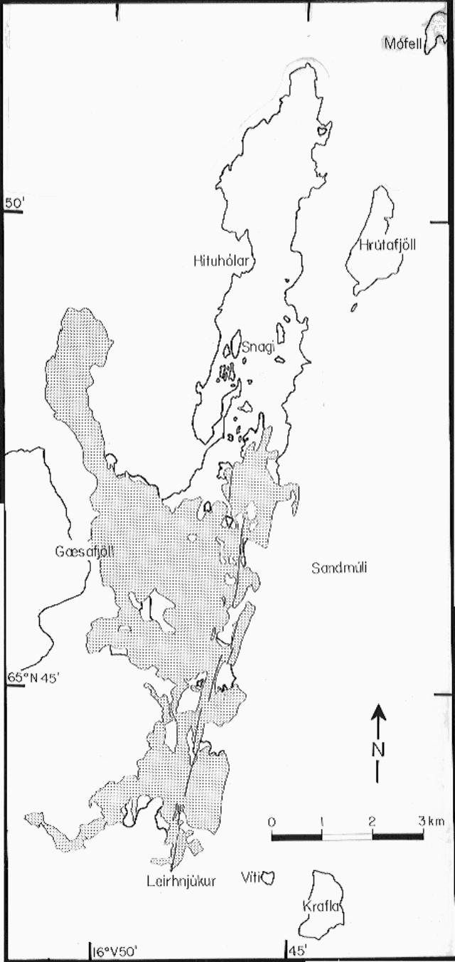 |
Figure 4. Krafla 16-23 November 1981 lava (stippled area) and eruption fissures (N-S-trending lines within stippled area). The area covered by lava from the December 1975-January 1981 eruptions is outlined. [Originally in 7:4]. |
"The initial tremor amplitude was higher in the caldera region than in most previous eruptions. The tremor was mixed with earthquakes, but low-frequency events began about 1 hour after the onset of tremor. The characteristics of the seismic activity changed when the eruption broke out. The irregular, high-frequency, intrusion tremor gave way to more regular, low-frequency, eruption tremor. Low-frequency earthquakes continued for about 1 hour after the outbreak of the eruption, but after that the eruption tremor was the only seismic disturbance seen on the seismographs.
"By about 0600 the force of the eruption was already decreasing. In the afternoon land deflation stopped and inflation resumed. Segments of the fissure stopped activity and the active segments gradually shortened. Activity in individual craters or crater groups decreased and became more pulsating. Substantial lava production lasted longest in craters about 5 km N of Leirhnjúkur. Activity on these craters increased rather suddenly on 20 November, doubling from an estimated 50 m3/s. During the same afternoon tiltmeters showed deflation lasting a few hours. But inflation resumed and about noon on 21 November lava production decreased rather suddenly to about 30 m3/s. By the morning of 22 November activity in these craters ceased. Activity continued in the initial S crater until 23 November, but lava production was minimal. About 0900 the activity stopped but resumed for about 15-20 minutes around 1700. After that no activity was recorded.
"After inflation resumed, the tiltmeters showed inflation rates similar to those following previous eruptions. The area covered by the new lava is estimated at about 15 km2 and the maximum land subsidence at 45-50 cm."
Geological Summary. The Krafla volcanic system in the Northern Volcanic Zone (NVZ) of Iceland is about 100 km long, consisting of a fissure swarm and a central volcano with a 7 x 9 km caldera formed about 110,000 years ago that deposited a rhyolitic welded tuff. It has been moderately active in the Holocene, over three distinct eruptive periods; the current one has lasted about 2,800 years with six volcano-tectonic episodes, each with one or more basaltic fissure eruptions. Lava volumes (DRE) have been in the 0.1-1 km3 range. The Hverfjall and Ludent tuff rings east of Myvatn were erupted along the fissure system. Myvatn lake formed during the eruption of the older Laxarhraun lava flow from the Ketildyngja shield volcano of the Fremrinamur volcanic system about 3,800 years before present (BP); The present Myvatn lake is constrained by the roughly 2,000 years BP younger Laxarhraun lava flow from the Krafla volcanic system. The abundant pseudocraters that form a prominent part of the Myvatn landscape were created when the younger Laxarhraun lava flow entered the lake. The last eruption took place in 1975-1984 CE when nine small basaltic fissure eruptions produced 0.25 km3 of lava.
Information Contacts: K. Grönvold, NVI; P. Einarsson, Univ. of Iceland.