Report on St. Helens (United States) — December 1981

Scientific Event Alert Network Bulletin, vol. 6, no. 12 (December 1981)
Managing Editor: Lindsay McClelland.
St. Helens (United States) Rock avalanches; no significant deformation
Please cite this report as:
Global Volcanism Program, 1981. Report on St. Helens (United States) (McClelland, L., ed.). Scientific Event Alert Network Bulletin, 6:12. Smithsonian Institution. https://doi.org/10.5479/si.GVP.SEAN198112-321050
St. Helens
United States
46.2°N, 122.18°W; summit elev. 2549 m
All times are local (unless otherwise noted)
After the entire dome showed very slow expansion through November, it subsided about 5 cm between early December and early January, and spread outward a roughly proportional amount (figure 21). Deformation of the crater floor surrounding the dome has typically begun a few weeks after past lava extrusion episodes, but as of 11 January there had been no significant deformation of the crater or of the edifice as a whole. No movement occurred along any of the small crater-floor thrust faults produced by past expansion of the dome, and no outward movement of the N crater rampart was detected. No changes in crater floor tilt were recorded. The average quantity of SO2 emitted daily has decreased steadily through 1981 and this trend continued in December and early January. Poor weather limited gas sampling to only 4 days in December, when 50-135 t/d of SO2 were emitted, with an average of about 100 t/d. SO2 emission rates were measured at 120 t/d on 7 January and 66 t/d on the 10th.
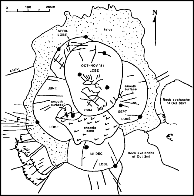 |
Figure 21. Sketch map of the 1982 Mt. St. Helens composite dome in the crater, prepared by D. Swanson. The dark circles indicate the positions of the 11 laser targets installed on the dome in late October,a before the latest lobe was extruded. Some of the small thrust faults in the crater floor around the dome are shown by hachured lines. |
Seismicity remained at a low level through December. Most of the 64 discrete earthquakes in the Mt. St. Helens area were aftershocks of the 13 February Elk Lake event (SEAN 06:02). Large rock avalanches from the crater walls occurred during periods of poor weather but were detected on seismographs. On 5 December, a 1-hour period of seismicity that began about 0200 included five events of more than 70 seconds duration, and two others of 40-70 seconds in length. Between 1200 and 1700 the same day, seven more events lasting 70 or more seconds were recorded, the longest (150 seconds) at 1607. Geologists observed rockfall debris covering much of the NE floor of the crater after this seismic episode. Debris from another large rockfall, on the NW crater floor, was discovered 23 December after geologists had been prevented from entering the crater by a week of wet weather. Seismic records did not show any activity that could be unequivocally associated with this rockfall. Most rockfalls have occurred during or just after storms and have not apparently been correlated with volcanic activity.
Geological Summary. Prior to 1980, Mount St. Helens was a conical volcano sometimes known as the Fujisan of America. During the 1980 eruption the upper 400 m of the summit was removed by slope failure, leaving a 2 x 3.5 km breached crater now partially filled by a lava dome. There have been nine major eruptive periods beginning about 40-50,000 years ago, and it has been the most active volcano in the Cascade Range during the Holocene. Prior to 2,200 years ago, tephra, lava domes, and pyroclastic flows were erupted, forming the older edifice, but few lava flows extended beyond the base of the volcano. The modern edifice consists of basaltic as well as andesitic and dacitic products from summit and flank vents. Eruptions in the 19th century originated from the Goat Rocks area on the N flank, and were witnessed by early settlers.
Information Contacts: T. Casadevall, D. Swanson, USGS, CVO, Vancouver, WA; C. Boyko, S. Malone, E. Endo, C. Weaver, University of Washington; R. Tilling, USGS, Reston, VA.