Report on El Chichon (Mexico) — March 1982
Scientific Event Alert Network Bulletin, vol. 7, no. 3 (March 1982)
Managing Editor: Lindsay McClelland.
El Chichon (Mexico) Large explosions; voluminous ashfalls; many deaths; first eruption in historic time
Please cite this report as:
Global Volcanism Program, 1982. Report on El Chichon (Mexico) (McClelland, L., ed.). Scientific Event Alert Network Bulletin, 7:3. Smithsonian Institution. https://doi.org/10.5479/si.GVP.SEAN198203-341120
El Chichon
Mexico
17.3602°N, 93.2297°W; summit elev. 1150 m
All times are local (unless otherwise noted)
After several weeks of local seismicity, explosions in late March and early April ejected a series of tephra columns, two of which penetrated well into the stratosphere. Officials reported that as many as 100 persons may have been killed by the eruption and associated seismic activity. Tephra falls were very heavy near the volcano, forcing tens of thousands of residents to flee their homes, and causing major damage to crops and livestock.
Activity during 28-29 March 1982. The eruption began 28 March at 2332 and NOAA geostationary weather satellite imagery showed that the eruption column was about 100 km in diameter 40 minutes later. Analysis of an infrared image returned at 0300 yielded a cloud top temperature of -75°C, corresponding to an altitude of 16.8 km, ~ 1 km above the tropopause. Surface and vault microbarographs and a KS36000 (SRO-type) seismograph operated by Teledyne Geotech near Dallas, Texas (1,797 km from El Chichón) received 22 minutes of infrasonic signals generated by explosive activity. Nine distinct signals were recorded, including a strong gravity wave, indicating that the eruption column struck the tropopause. Instruments at McMurdo, Antarctica, 11,865 km from El Chichón, recorded about 2 hours of infrasonic signals. Nine intensity peaks were detected, of which five were clearly from the eruption.
Vigorous feeding of the plume continued for several hours but had clearly ended by 0600. A dense tephra cloud drifted ENE from the volcano and a much more diffuse plume moved in roughly the opposite direction (figure 1). By 0530 the next morning, satellite images showed the main plume extending from the Yucatán Peninsula, S of Cuba, to Haiti, and remnants of the more diffuse plume over the E Pacific Ocean at about 15°N, and 118-119°W. The U. S. National Weather Service analyzed wind directions and speeds at different altitudes near the volcano, and concluded that the ENE drift of the dense cloud indicated that it was in the upper troposphere, whereas the diffuse plume blown to the WSW was in the middle troposphere at roughly 6-7.5 km altitude. Initially, none of the tephra appeared to be drifting in a direction consistent with the lower stratospheric circulation, but significant aerosol development in the stratosphere is indicated by the lidar measurements described in the next-to-last paragraph of this report.
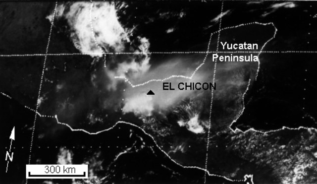 |
Figure 1. NOAA geostationary weather satellite image returned 29 March at 1000, about 10.5 hours after El Chichón's initial explosion. A dense upper tropospheric eruption cloud drifts ENE, and a more diffuse cloud drifts WSW, probably in the mid-troposphere. |
Heavy ashfall was reported from towns near the volcano. At Pichucalco, ~20 km NE of the summit, 15 cm of ash was reported, and 5 cm of ash fell at Villahermosa (population 100,000), 70 km NE of the volcano. Residents of Nicapa, a village on the NE flank, took refuge in a church that was toppled by a M 3.5 earthquake, killing 10 people and injuring about 200. Initial estimates of the number of additional deaths varied, ranging as high as 100, and many more were probably killed on the SW flank during this or subsequent eruptions (see 5 paragraphs below). Most of the casualties on the N flank were reportedly caused by fires started by incandescent airfall tephra. Tens of thousands of people fled the area. The heavy ashfall forced the closure of roads and the airports at Villahermosa and Tuxtla Gutiérrez (~ 70 km S of the volcano). Cocoa, coffee, and banana crops were destroyed, and the cattlemen's association requested that animals from a wide area be transported for butchering because ashfall had made grazing impossible.
Activity during 30 March-3 April 1982. A second but much smaller explosion was observed on the satellite imagery at about 0900 on 30 March. A thin plume drifted E about 120 km before dissipating. A somewhat larger explosion that was first visible at 1500 produced a cloud that rose into the mid-troposphere and moved about 350 km N. Activity was declining by 1900. Haze was widespread over central México, reducing visibility to about 8 km in México City ( ~ 650 km WNW of the volcano) and to only about 3 km in Tampico (~ 750 km NW of the volcano). A small explosion shortly before 1330 on 31 March produced a plume that reached the upper troposphere and blew to the E but dissipated quickly.
A small explosion during the early afternoon of 2 April ejected a mushroom-shaped cloud that rose to ~ 3.5 km altitude in 30 minutes. Satellite images showed renewed explosive activity early 3 April. An eruption column was emerging from the volcano by 0300 and blew to both the NE and SW. A series of gravity waves and acoustic signals from this activity were again recorded by Teledyne Geotech instruments near Dallas, Texas. The calculated start time for this activity was 0250 and signals continued for 14 minutes. As with the initial explosion 28 March, the powerful gravity waves generated by this event indicated that the eruption column struck the tropopause forcefully. Smaller explosions, calculated to have begun at 0312, generated acoustic waves and a single gravity wave that were received near Dallas for 10 minutes. During the next 5 hours, ash drifted over N Guatemala and Belize. At Nicapa, on the NE flank, 7.5 cm of new ash was reported and a haze of SO2 was visible during the day. Explosive activity resumed about 2000. Acoustic data recorded by Teledyne Geotech indicated that explosions probably occurred every 2-3 minutes, generating a few initial gravity waves and a complex series of acoustic waves that continued for 48 minutes. The total acoustic energy of this activity was significantly greater than that produced by the early morning explosions, and the eruption plume was denser and probably rose somewhat higher. It was initially elongate NE-SW and drifted over S México, N Guatemala and Belize. By noon the next day, a faint plume extended to about 25°N, 79°W, almost to Cuba, and lower altitude material, probably at only ~ 1.5 km, was drifting directly northward along the 95°W meridian.
Activity during 4 April 1982. A stronger explosion, possibly larger than the initial event on 28 March, first appeared on the NOAA geostationary weather satellite image returned at 0530 on 4 April and was reported by ground observers to have started at 0522. An infrared image 3.5 hours later showed a temperature of -76°C at the top of the eruption cloud, corresponding to an altitude of 16.8 km, identical to the altitude measured from the 28 March plume. Wind speeds near the volcano apparently remained relatively low and most of the cloud remained over S México and N Guatemala more than 24 hours later. In Pichucalco (~ 20 km NE of the summit) incandescent tephra could be seen rising from the volcano and the ash cloud darkened the sky during the morning as though it were night. Felt earthquakes were also reported early 4 April. At Ixtacomitán, 18 km ENE of the summit, there was a heavy fall of tephra no larger than 4 cm in diameter and the army was sent to evacuate 3,000 residents. No casualties were reported. All villages within 15 km of the summit had previously been evacuated and tens of thousands of people had fled their homes. Government officials reported ashfall over an area of 24,000 km2 and crop damage of $55,000,000.
A pumice flow deposit from the 4 April eruption extended ~ 5 km NE from the summit, terminating ~ 2 km from Nicapa. At its distal end, the deposit was about 100 m wide and 3 m thick and contained pumice blocks 1 m in diameter. Temperatures measured by a thermocouple at 40 cm depth on 8 April averaged 360°C, and were as high as 402°C. The pumice flow deposit appeared to have been emplaced as two separate events in rapid succession. Shortly afterward, an ash flow flattened trees in the valley surrounding the pumice flow deposit and left a relatively thin layer of ash that had a temperature of 94°C at 10 cm depth 3 days later.
Airfall tephra thickness in Nicapa, 7 km NE of the summit, totaled 25-40 cm [but see 7:4] after the 4 April eruption. Bombs as large as 50-60 cm in diameter had made numerous holes in the roofs of houses and many other roofs had collapsed. In hand specimen, the tephra appeared to be a crystal-rich andesite or dacite containing hornblende and considerable feldspar. In Ostuacán, 12.5 km NW of the summit, tephra was 15-20 cm thick after the 4 April eruption, including pumice as large as 15 cm in diameter. Many roofs had been destroyed. Extreme heat made it impossible to approach the village of Francisco León, 5 km SW of the summit. Midway between Ostuacán and Francisco León, a river was boiling and flattened trees could be seen upslope. Geologists thought it was likely that pyroclastic flows had moved through the area. Of the roughly 1,000 residents of Francisco León, about half had reportedly left before the eruption because of the many felt earthquakes in February and March, but the remainder were missing in early April. A helicopter flight over the village during the first week in April revealed no signs of life. Because of the danger of mudflows when the rainy season begins around the end of April, authorities established a prohibited zone extending outward 10 km from the summit.
By 5 April, the low-altitude plume from the second 3 April explosion had reached the S Texas coast and Brownsville reported visibility of only 6.5 km in haze. A few flights into small S Texas airports were cancelled, but winds initially forced most of this material into the Gulf of México. Low-altitude (1.5-2 km) ejecta from the 4 April explosion also moved northward, and a slight change in wind direction blew the ash cloud further N and inland over Texas by late 7 April. A light ashfall occurred in Houston during the night of 7-8 April and samples were collected for analysis by NASA geologists.
Activity during 5-11 April 1982. A plume generated by a smaller explosion was observed on satellite imagery at 1130 on 5 April. Ground observers reported that the comparatively minor activity lasted about 3 hours and that no incandescent tephra was ejected. A similar but possibly slightly larger explosion could be seen on the satellite image returned at 0930 on 6 April. Geologists reported that earthquakes as strong as magnitude 1.5 were recorded about every 3 minutes 6 April. Geologists working a few km NE of the summit reported that about 2 mm of wet ash fell at about 1000 on 8 April and 1130 on the 9th. Satellite images returned at 0728 on 9 April and 0238 on 10 April both showed small diffuse plumes, drifitng NNE and SSE respectively.
Data from laser radar (lidar) measurements at Mauna Loa Observatory, Hawaii (about 19.5°N, 155.6°W) during the nights of 9-10 and 10-11 April indicated that El Chichón had injected large quantities of volcanic material into the stratosphere. Several layers were detected, with strongest backscattering at an altitude of 25.7 km. Analysis of wind conditions at 25 km altitude in Hawaii and México indicated a likely drift of ~ 5-7 m/s (roughly 430-600 km/day) towards the W, which would carry volcanic debris from El Chichón to Hawaii in 1.5 to 2 weeks. Inspection of a satellite image returned late 11 April showed a moderately dense cloud extending from México to just W of Hawaii, spreading from roughly 300 km wide near the Mexican coast to nearly 850 km near its distal end.
No previous eruptions of El Chichón are known in historic time. Before the 1982 eruption, the volcano was heavily forested, with a shallow crater, 1,900 X 900 m, elongate NNW-SSE. Solfataras and hot springs were present in the crater and on the flanks. Müllerried (1933) describes voluminous airfall deposits from previous eruptions that he believed to be post-Pleistocene.
Reference. Müllerried, F.K.G., 1933, El Chichón, unico volcán en actividad en el sureste de México: Universidad de México, v. 5, no. 27, p. 156-170.
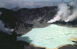
Geological Summary. El Chichón is a small trachyandesitic tuff cone and lava dome complex in an isolated part of the Chiapas region in SE México. Prior to 1982, this relatively unknown volcano was heavily forested and of no greater height than adjacent non-volcanic peaks. The largest dome, the former summit of the volcano, was constructed within a 1.6 x 2 km summit crater created about 220,000 years ago. Two other large craters are located on the SW and SE flanks; a lava dome fills the SW crater, and an older dome is located on the NW flank. More than ten large explosive eruptions have occurred since the mid-Holocene. The powerful 1982 explosive eruptions of high-sulfur, anhydrite-bearing magma destroyed the summit lava dome and were accompanied by pyroclastic flows and surges that devastated an area extending about 8 km around the volcano. The eruptions created a new 1-km-wide, 300-m-deep crater that now contains an acidic crater lake.
Information Contacts: C. Lomnitz, S. de la Cruz-Reyna, F. Medina, UNAM, México; M. Krafft, Cernay; D. Haller, C. Kadin, M. Matson, NOAA/NESS; A. Krueger, NOAA/NWS; F. Mauk, Teledyne Geotech; C. Wilson, Univ. of Alaska; K. Coulson, T. DeFoor, MLO, HI; C. Wood, NASA, Houston; Notimex Radio, México; New York Times; UPI.