Report on El Chichon (Mexico) — April 1982
Scientific Event Alert Network Bulletin, vol. 7, no. 4 (April 1982)
Managing Editor: Lindsay McClelland.
El Chichon (Mexico) 4 April stratospheric cloud circles the globe; minor explosive and seismic activity continues
Please cite this report as:
Global Volcanism Program, 1982. Report on El Chichon (Mexico) (McClelland, L., ed.). Scientific Event Alert Network Bulletin, 7:4. Smithsonian Institution. https://doi.org/10.5479/si.GVP.SEAN198204-341120
El Chichon
Mexico
17.3602°N, 93.2297°W; summit elev. 1150 m
All times are local (unless otherwise noted)
The 28 March explosion produced heavy tephra falls N of the volcano, but the initial press reports of the thickness of ash deposits, included last month, were exaggerated. A series of three explosions of increasing size occurred 3-4 April, the last of which, at 0522 on 4 April, was the largest of the eruption and produced a major stratospheric cloud. Conflicting reports persist about the fate of the approximately 1,000 residents of a SW flank village that was apparently in the path of one or more pyroclastic flows ejected 28 March or 3-4 April.
Infrasonic data. At College, Alaska (6,634 km from the volcano), about an hour of acoustic signals were received from both the 28 March and 4 April explosions. Antipodal acoustic-gravity wave signals from the first 3 April and 4 April explosions were detected at Tennant Creek, Australia (19.52°S, 134.25°E).
Volume and composition of tephra. Tephra samples were collected from about 100 sites around El Chichón in mid-April. Near the volcano, three separate layers were evident, ejected by explosions 28 March, 3 April (at 2000), and 4 April. Farther away, only 28 March and 4 April tephra had been deposited. The axis of maximum deposition extended approximately N from the summit for the 28 March tephra and roughly E from the summit for the 4 April material. Both layers were normally-graded but the 3 April layer, where present, consisted only of fine ash. James Luhr calculated that [~0.30] km3 of tephra (converted to a density of 2.6 g/cm3) had fallen within the 0.1 cm isopach (figure 2). X-ray fluorescence analyses of pumice samples showed no significant variation in chemical composition, either within individual units or between units. The pumice, a porphyritic trachyandesite, has a whole-rock silica content of about 57.5%; silica content of the glass is about 61%.
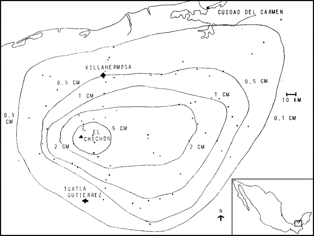 |
Figure 2. Isopach map showing thickness of compacted ash at a density of 1.2 g/cm3, for tephra ejected from El Chichón, 28 March-4 April 1982. Courtesy of James Luhr. |
Minor activity during April-May. No large explosions have taken place since 4 April, but occasional minor ash emission continued. The active crater, ~ 600 m in diameter in early May, was located within the pre-existing shallow summit crater that had dimensions of ~ 1,900 X 900 m. A 12-km prohibited zone around the summit remained in effect in early May. A four-station seismic monitoring network operated by the UNAM recorded 6-8 small earthquakes per day in early May, including some B-type events. The ejection of a minor ash column on 11 May was accompanied by a few small discrete earthquakes centered at about 2 km depth, and additional seismicity that may have been harmonic tremor.
Stratospheric cloud. Careful inspection of visible satellite imagery from the NOAA 6 and 7 polar orbiters, the GOES East and West (U.S.), GMS (Japan), and Meteosat (Europe) geostationary weather satellites has permitted the tracking of the densest portion of the 4 April stratospheric cloud as it circled the globe from E to W. The cloud reached Hawaii by 9 April, Japan by 18 April, the Red Sea by 21 April, and had crossed the Atlantic Ocean by 26 April, dipping S to about 5°N at its W edge. Diffusion into higher latitudes appeared to be very limited. During its first circuit of the globe, the cloud could be seen in part (but usually not all) of the range 5-30°N, sometimes occupying a band roughly 15-20° wide. Tracking of the cloud after late April has been difficult, but careful work may allow the position of the cloud front to be established after that date. Ozone data from the Nimbus-7 polar orbiting satellite, available for the two weeks following the cloud's ejection, allowed its path to be clearly traced, and scientists at NASA's Goddard Space Flight Center hope to continue observations of its position as more satellite data arrives. A balloon flight from Laramie, Wyoming (41.33°N, 105.63°W) in mid-April detected a sharp peak at 17 km (just below the tropopause at 18 km).
Lidar stations in the U.S., Japan, and Europe recorded enhanced backscattering in the stratosphare at times that correlated well with satellite observations of the cloud's movement. Very strong signals were detected by stations at lower latitudes, while the cloud appeared to be present only intermittently and near the base of the stratosphere over mid-latitude stations. A possible northward diffusion of the cloud, probably on its second circuit of the globe, is shown by the sharply higher backscattering ratios detected at Fukuoka, Japan (33.65°N, 130.35°E) in May. At lower latitudes, the strongest layers were centered above 25 km. The highest layer detected was at 29.7 km altitude.
Persons in the SW U.S. observed phenomena that indicated the presence of stratospheric layers. A Bishop's Ring was first seen from Houston, Texas on 11 April and has been intermittently visible since. The 22° angular distance from the sun indicated a particle size of 0.7-0.9 µm. Unusual sunrises and sunsets have been reported from E Texas since 24 April. From Tucson, Arizona, Aden and Marjorie Meinel observed a primary scattering layer at 13.2 km and a weaker layer at 20 km around sunset on 30 April. By early May, the aerosol cloud had become extremely dense, with most of the material between 14 and 18 km and a trace to 20.5 km. The main body of the layer appeared to pass NW of Tucson during the evening of 7 May. Long windrows of aerosol were visible, similar to the phenomenon seen after the 1976 Augustine eruption. The conspicuous clouds had nearly disappeared by 9 May, but a strong aureole remained around the sun all day 10 May.
The high altitude of the cloud made direct sampling difficult and none has been possible in the densest portion above 25 km. Flights from the NASA Ames Research Center near San Francisco to about 23°N on 19 April and 5 May sampled the base of the cloud at about 19 km altitude. Optical depths of the cloud as measured with a sun photometer reached 0.3-0.4, increasing southward. Particles ranging in size from 0.1 to 3 µm were collected. Sulfuric acid droplets were common, but there were very few silicate particles. However, NaCl crystals were a significant component and salt has apparently never before been found in significant quantities in a volcanic cloud. Measurement of the degree of depolarization of layers detected at 15-16.5 km and 24-25.5 km on 22 April by lidar equipment at Nagoya University (about 35°N, 137°E) suggested that particles in the lower layer were strongly non-spherical, while those in the upper layer were mostly spherical droplets.
Further Reference. Krueger, A.J., 1983, Sighting of the El Chichón sulfur dioxide clouds with the Nimbus-7 Total Ozone Mapping Spectrometer: Science, v. 220, p. 1377-1379.
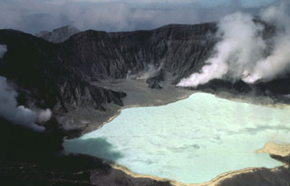
Geological Summary. El Chichón is a small trachyandesitic tuff cone and lava dome complex in an isolated part of the Chiapas region in SE México. Prior to 1982, this relatively unknown volcano was heavily forested and of no greater height than adjacent non-volcanic peaks. The largest dome, the former summit of the volcano, was constructed within a 1.6 x 2 km summit crater created about 220,000 years ago. Two other large craters are located on the SW and SE flanks; a lava dome fills the SW crater, and an older dome is located on the NW flank. More than ten large explosive eruptions have occurred since the mid-Holocene. The powerful 1982 explosive eruptions of high-sulfur, anhydrite-bearing magma destroyed the summit lava dome and were accompanied by pyroclastic flows and surges that devastated an area extending about 8 km around the volcano. The eruptions created a new 1-km-wide, 300-m-deep crater that now contains an acidic crater lake.
Information Contacts: F. Medina, UNAM, México; J. Luhr, Univ. of California, Berkeley; M. Matson, D. Haller, C. Kadin, NOAA/NESS; B. Mendonça, NOAA/ERL; K. Coulson, MLO, HI; M. Hirono, Kyushu Univ.; W. Fuller, NASA Langley Research Center; Y. Iwasaka, Nagoya Univ.; R. Chuan, Brunswick Corp.; C. Wilson, Univ. of Alaska; D. Christie, Australian National Univ.; J. Rosen, Univ. of Wyoming; A. Meinel, M. Meinel, Univ. of Arizona; M. Helfert, NOAA, Houston TX; W. Evans, ARPX, Atmospheric Environment Service, Canada.