Report on Long Valley (United States) — May 1982

Scientific Event Alert Network Bulletin, vol. 7, no. 5 (May 1982)
Managing Editor: Lindsay McClelland.
Long Valley (United States) Seismic swarms; new fumaroles; uplift
Please cite this report as:
Global Volcanism Program, 1982. Report on Long Valley (United States) (McClelland, L., ed.). Scientific Event Alert Network Bulletin, 7:5. Smithsonian Institution. https://doi.org/10.5479/si.GVP.SEAN198205-323822
Long Valley
United States
37.7°N, 118.87°W; summit elev. 3390 m
All times are local (unless otherwise noted)
Since the four M 5.5-6.1 earthquakes of 25-27 May, 1980, eight seismic swarms have occurred in the S part of the caldera (table 1). Most lasted roughly 1-2 hours and consisted of several hundred events, including some B-type shocks. All of the swarms included periods of spasmodic tremor, produced by a succession of earthquakes too closely spaced to allow clear separation into discrete events on seismograph records. Some earthquakes were also recorded between swarms. In January 1982, a new group of fumaroles was discovered in the vicinity of Casa Diablo Hot Springs, about 2.5 km E of the earthquake epicenters, and existing fumaroles in the area had become more vigorous. The most recent swarm began 7 May at 0517 with a 40-minute burst of seismicity. Occasional 5-10-minute periods of spasmodic tremor were recorded during the next 24 hours. The swarm's strongest earthquake was a M 4.3 event at 2047. Depths of the 7-8 May events ranged from 3.8 to 8.5 km below the surface, comparable to the 9-10 July 1981 swarm, but substantially shallower than others since May 1980. Epicenters were about a half km N of those from previous swarms.
Table 1. Data from seven seismic swarms at Long Valley Caldera, June 1980-August 1981, courtesy of Alan Ryall. Analysis of data from the 7-8 May 1982 swarm is in progress.
| Date | Average Depth (km) | Standard Error (km) | Largest Event Magnitude | Number of Events Located |
| 07 Jun 1980 | 8.4 | 1.2 | 3.5 | 6 |
| 02-03 Jul 1980 | 8.0 | 1.0 | 4.2 | 14 |
| 03 Aug 1980 | 8.2 | 1.3 | 3.4 | 7 |
| 25 Nov 1980 | 7.8 | 1.3 | 3.4 | 5 |
| 21 Apr 1981 | 8.5 | 3.0 | 2.8 | 6 |
| 09-10 Jul 1981 | 5.9 | 1.3 | 3.2 | 30 |
| 09 Aug 1981 | 9.0 | 2.9 | 3.4 | 5 |
In October 1980, a survey along the highway that passes through the caldera showed as much as 25 cm of uplift of the caldera's resurgent dome, possibly within the previous 2 years. A 10 km-long geodimeter line over the dome, remeasured in May 1982, showed 50 cm of lateral spreading since 1978. Dry tilt stations, installed 8-9 May over the earthquake swarm epicentral area, showed no changes when reoccupied about three weeks later.
Miller and others (1982) noted that "A preliminary interpretation of this evidence is that magma at depth in the Long Valley Caldera moved upward at about the time of the May 1980 swarm of earthquakes. This caused bulging of the resurgent dome and opened fractures at depth in the S part of the caldera (R.A. Bailey and R. Cockerham, written communication, 1982), thereby allowing a tongue of magma to move toward the surface beneath the epicentral site . . . ." On 25 May 1982, the USGS issued a notice of potential volcanic hazard for the Long Valley area, adding to the earthquake hazard watch in effect since 27 May 1980.
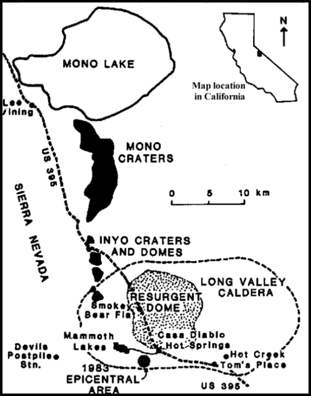 |
Figure 1. Sketch map of Long Valley Caldera, after Bailey et al. (1976), and Miller, et al. (1982). |
Reference. Miller, C.D., Crandell, D.R., Mullineaux, D.R., Hoblitt, R.P., and Bailey, R.A., 1982, Preliminary Assessment of Potential Volcanic Hazards in the Long Valley-Mono Lake Area, East-Central California and Southwestern Nevada; USGS Open File Report 82-583.
Geological Summary. The large 17 x 32 km Long Valley caldera east of the central Sierra Nevada Range formed as a result of the voluminous Bishop Tuff eruption about 760,000 years ago. Resurgent doming in the central part of the caldera occurred shortly afterwards, followed by rhyolitic eruptions from the caldera moat and the eruption of rhyodacite from outer ring fracture vents, ending about 50,000 years ago. During early resurgent doming the caldera was filled with a large lake that left strandlines on the caldera walls and the resurgent dome island; the lake eventually drained through the Owens River Gorge. The caldera remains thermally active, with many hot springs and fumaroles, and has had significant deformation, seismicity, and other unrest in recent years. The late-Pleistocene to Holocene Inyo Craters cut the NW topographic rim of the caldera, and along with Mammoth Mountain on the SW topographic rim, are west of the structural caldera and are chemically and tectonically distinct from the Long Valley magmatic system.
Information Contacts: R. Bailey, USGS, Reston, VA; C.D. Miller, D. Mullineaux, USGS, Denver, CO; A. Ryall, University of Nevada, Reno.