Report on El Chichon (Mexico) — May 1982
Scientific Event Alert Network Bulletin, vol. 7, no. 5 (May 1982)
Managing Editor: Lindsay McClelland.
El Chichon (Mexico) Fatal flood after natural pyroclastic dam fails; stratospheric cloud effects; eruption summary
Please cite this report as:
Global Volcanism Program, 1982. Report on El Chichon (Mexico) (McClelland, L., ed.). Scientific Event Alert Network Bulletin, 7:5. Smithsonian Institution. https://doi.org/10.5479/si.GVP.SEAN198205-341120
El Chichon
Mexico
17.3602°N, 93.2297°W; summit elev. 1150 m
All times are local (unless otherwise noted)
The following summary was prepared by L. Silva, J.J. Cochemé, R. Canul, W. Duffield, and R. Tilling. "Violent eruptions of the stratovolcano El Chichón destroyed its summit dome and formed a 1-km-wide crater. Field studies and eyewitness accounts indicate that the initial activity (28-29 March) was phreatomagmatic, and produced a Plinian column over 15 km high and tephra deposits extending more than 200 km downwind. More vigorous activity 3-4 April produced several pyroclastic flows, some more than 15 m thick, followed by two airfall deposits. Distal sections consist of three airfall layers whereas proximal sections include pyroclastic flows. The total volume of eruptive products is probably less than 0.5 km3, much of which is juvenile pumice, which is highly porphyritic with plagioclase, amphibole, and clinopyroxene as major phenocrysts. Petrographic and chemical data suggest an alkali-rich 'andesitic' composition. The high alkali content of the pumice, occurrence of anhydrite in tephra, and presence of halite in the stratospheric cloud reflect contamination by evaporites. Villages within a 7-km radius were entirely destroyed or heavily damaged. Pyroclastic flows dammed a river and created a 5-km long lake of hot water; the failure of the natural dam on 26 May caused a destructive flood. Study of pre-1982 deposits indicates that El Chichón has developed by several cycles of pyroclastic eruptions, with or without a subsequent growth of domes, with the last pre-1982 pyroclastic eruption about 130 years ago. The current activity may continue and could include dome emplacement."
Premonitory seismicity. During field work at El Chichón between December 1980 and February 1981, more than 1 year before the eruption, Rene Canul heard loud noises and felt small earthquakes near the central dome, and could also feel some events while on the flanks of the volcano. People living near the volcano reported felt earthquakes several months before the eruption.
March-April explosions. The March and April explosions destroyed most of the former central lava dome and formed a new crater ~ 1 km in diameter and slightly elongate NW-SE. In early June, there were several explosion pits on the floor of the new crater, all of which were filled with boiling water or mud and were emitting vapor. Although heavy rains had compacted the ash, 3-4 m remained at the rim of the new crater.
The army reported that 187 deaths were caused directly by the eruption. Among the deaths were one geologist and 32 soldiers sent to the village of Francisco León, ~ 6 km SW of the summit, after the 28-29 March explosion. The pyroclastic flow that traveled through Francisco León left only a thin deposit, but of the structures in the village, only one wall of the church, parallel to the direction of the pyroclastic flow's movement, remained standing.
All of the volcano's major drainages contained pyroclastic flow deposits, which were more than 15 m thick in some of the deeper valleys. These deposits were still hot in late May and were occasionally the source of small secondary explosions. In the two months since the March-April explosions, as much as 20 m of erosion has taken place in some areas and fan deposits have formed at the base of the volcano.
May activity and flood. Lakes formed behind natural dams of new pyroclastic flow deposits at several sites around the volcano. The largest lake, in the valley of the Río Magdalena at the SW foot of the volcano, grew about 1 m deeper each day until 26 April, then more slowly, eventually reaching 5 km in length and several million m3 in volume. Late 26 May, the pyroclastic dam holding back this water failed. Seismographs recorded the draining of the lake over a period of about 1 hour, sending a flood of hot water downstream. At Ostuacán, more than 10 km from the dam, the water temperature was measured at 82°C. Most residents of low-lying areas had been evacuated, but at a hydroelectric project 35 km downstream one worker was killed and three were badly burned by 52°C water. The flood also destroyed a bridge several kilometers from the pyroclastic dam. Geologists inspecting the former lake bed in early June saw a series of strand lines several meters high, indicating that the lake had been draining slowly before the dam failed.
No large explosions have occurred at El Chichón since 4 April. Minor ash emission continued through early May but none has been reported since the 11th. A four-station Instituto de Geofísica seismic net N of the volcano recorded 4-7 very small events per day in late May.
By late May, significant revegetation had begun in some areas devastated by the eruption. Near Nicapa (~ 7 km NE of the summit), coconut trees totally denuded by the 4 April explosion showed new leafy growth. Some residents had returned to Nicapa and cattle were grazing in the area. Closer to the summit, fields that had been completely buried contained tufts of grass about 1/3 m high.
Stratospheric cloud. The major stratospheric cloud ejected by El Chichón has remained concentrated over lower northern latitudes, but lidar data and observations of brilliant sunsets appeared to indicate the beginning of significant northward dispersal in early June. However, with NASA's SAGE satellite no longer functional, determination of the extent of the cloud at any given time is very difficult. Through mid-May, wind data from Hilo, Hawaii showed a strong (up to 240 km/h), steady W to E flow between 10 and 20-22 km altitude, and a steady, 50-60 km/h E to W flow above 25-26 km. Between these levels, winds were light and variable. No significant N-S component had developed above 10 km since the El Chichón eruption. Lidar at Mauna Loa, Hawaii and Fukuoka, Japan continued to detect dense layers of stratospheric material through early June, at altitudes of as much as 32 km over Hawaii. University of Wyoming balloon flights from Laredo, Texas 17-19 May passed through two primary layers, at 15-20 km and 24-27 km altitude. In the upper layer there were more than 500 particles of less than 0.01 µm/cm3 and about 20 particles larger than 1 µm/cm3.
April 1982 NOAA 7 satellite data between 120°E and 122.5°W showed an apparent increase in albedo (visible band) and an apparent decrease in outgoing longwave radiation (thermal infrared band) between 15°N and 35°N, peaking at 23°-26°N, when compared with the zonal average from the previous 4 years. Further analysis of samples collected 5 and 7 May during NASA Ames Research Center flights south from San Francisco shows particles ranging from less than 0.1 µm to several µm at the base of the cloud (about 19 km altitude). Silicates and halite crystals of several µm in size were found. Halite concentration was only a few percent of the amount of H2SO4 sampled, but H2SO4 was not as dominant as in many previous volcanic clouds. Geologists suggested that the halite sampled by NASA and anhydrite found in tephra near the volcano are probably the result of contamination by evaporites, which were found in bedrock penetrated by two Petroleos Mexicanos drillholes near El Chichón.
From Tucson, Arizona on 14 May, Aden and Marjorie Meinel observed a roughly 40 X 400 km band of smoky clouds pass overhead during the afternoon, but at sunset these clouds appeared to be at an altitude of only 8 km. A dense veil covered the sky 15-16 May. A brilliant fiery red glow appeared 35 minutes after sunset on 16 May. The top of this glow was at 24 km, the highest altitude observed from Tucson thus far. A feature similar to Bishop's Ring was observed 17 May and windrows of aerosol moved over Tucson later that afternoon. A dense veil was present 18 May but was nearly gone on the 19th and skies were almost normal early 20 May. From Kitt Peak National Observatory near Tucson, extinction of two times normal at 3,900 was measured in mid-May. Scattering was about equal at all wavelengths except near-infrared, where the cloud was more transparent. Unusual twilight colors were observed through mid-May from Flagstaff, Arizona, and extinction coefficients measured there were about three times the normal value [Livingston and Lockwood, 1983]. A strong haze has been present over Houston, Texas since early May. Spectacular sunsets were observed there in late May and early June and the haze blotted out stars during the night of 2-3 June. Similar conditions plus a Bishop's Ring were seen from Austin, Texas during the night of 5-6 June. From Norwich, England, H.H. Lamb observed a rose-colored pillar of light at sunset 27 April and 9 May. At sunset 10-12 May, this phenomenon was accompanied by brilliant orange to fiery red diffused light that extended to 3-4 sun diameters. Strongly diffused light extended 2-3 diameters from a fiery red sun on 23 May. From the dimensions of the extended twilight illumination, Lamb estimated that the layer was at very roughly 20 km altitude. Lamb saw no abnormal effects on other evenings, although poor weather frequently made observations impossible.
By early June, lidar observations and reports of unusual sunsets indicated that the cloud was beginning to move northward. Lidar operated by NASA at Hampton, Virginia (37.1°N, 76.3°W), began to detect layers at higher altitudes in early June. After a brilliant sunset on 14 June, a dense layer at 20.2-23.1 km was accompanied by material at 26.5 km. However, as of early June, lidar stations in Italy and West Germany had not detected layers at these altitudes. Enhanced sunsets with definite striations began 4 June in Boulder, Colorado and continued for the next several days. Residents of Jacksonville, Florida also began to see brilliant sunsets 4 June.
[Details of the continuing dispersal of the stratospheric cloud are reported in Atmospheric Effects.]
Further References. Guerrero, J.C. (ed.), 1983, El Volcán Chichonal: Instituto de Geología, Universidad Nacional Autónoma de México, 100 p. (9 papers).
Havskov, J., de la Cruz-Reyna, S., Singh, S.K., Medina, F., and Gutiérrez, C., 1983, Seismic activity related to the March-April, 1982 eruptions of El Chichón Volcano, Chiapas, México: Geophysical Research Letters, v. 10, no. 4, p. 293-296.
Livingston, W., and Lockwood, G.W., 1983, Volcanic ash over Arizona in the spring of 1982: Astronomical Observations: Science, v. 220, p. 300-302.
Luhr, J.F., and Varekamp, J.C. (eds.), 1984, El Chichón Volcano, Chiapas, México: JVGR, v. 23, no. 1/2, p. 1-191 (8 papers).
Sigurdsson, H., Carey, S.N., and Fisher, R.V., 1987, The 1982 eruptions of El Chichón Volcano, México (3): Physical Properties of Pyroclastic Flows: BV, v. 49, p. 467-488.
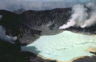
Geological Summary. El Chichón is a small trachyandesitic tuff cone and lava dome complex in an isolated part of the Chiapas region in SE México. Prior to 1982, this relatively unknown volcano was heavily forested and of no greater height than adjacent non-volcanic peaks. The largest dome, the former summit of the volcano, was constructed within a 1.6 x 2 km summit crater created about 220,000 years ago. Two other large craters are located on the SW and SE flanks; a lava dome fills the SW crater, and an older dome is located on the NW flank. More than ten large explosive eruptions have occurred since the mid-Holocene. The powerful 1982 explosive eruptions of high-sulfur, anhydrite-bearing magma destroyed the summit lava dome and were accompanied by pyroclastic flows and surges that devastated an area extending about 8 km around the volcano. The eruptions created a new 1-km-wide, 300-m-deep crater that now contains an acidic crater lake.
Information Contacts: L. Silva M., J-J. Cochemé, S. de la Cruz-Reyna, F. Medina, M. Mena, J. Havskov, S. Singh, UNAM, México; R. Canul D., Comisión Federal de Electricidad, Morelia; R. Tilling, USGS, Reston, VA; W. Duffield, USGS, Menlo Park, CA; W. Fuller, NASA Langley Research Center; T. DeFoor, MLO, Hawaii; M. Hirono, Kyushu Univ.; B. Mendonça, NOAA/ERL; J. Rosen, Univ. of Wyoming; R. Chuan, Brusnwick Corp.; M. Matson, NOAA/NESS; A. & M. Meinel, W. Livingston, Univ. of Arizona; B. Skiff, Lowell Observatory; M. Helfert, NOAA, Houston TX; H. Lamb, Univ. of East Anglia; J. Nania, Deaconess Hospital, Spokane, WA; Numero Uno newspaper, Tuxtla Gutierrez.