Report on Guagua Pichincha (Ecuador) — June 1982

Scientific Event Alert Network Bulletin, vol. 7, no. 6 (June 1982)
Managing Editor: Lindsay McClelland.
Guagua Pichincha (Ecuador) Phreatic explosions; new fumaroles; seismicity
Please cite this report as:
Global Volcanism Program, 1982. Report on Guagua Pichincha (Ecuador) (McClelland, L., ed.). Scientific Event Alert Network Bulletin, 7:6. Smithsonian Institution. https://doi.org/10.5479/si.GVP.SEAN198206-352020
Guagua Pichincha
Ecuador
0.171°S, 78.598°W; summit elev. 4784 m
All times are local (unless otherwise noted)
"Since the initiation of activity in August 1981 there had been a progressive increase, although irregular, in fumarolic activity within the summit crater. Prior to this, the volcano had apparently been quiet since 1881.
"The major fumarolic activity remained associated with the 625-m-diameter dacitic dome, which covers much of the crater floor. The new vent area, on the NE side of the dome, continued as one of the principal steam vents. Originally consisting of several small vents in line, the NE vents had grown to form one principal crater, approximately 50 m in diameter, plus another crater. Occasional phreatic explosions ejected ash and rock fragments. There was no evidence of new magmatic material in the ejected debris.
"Two older vents on the dome also remained active, producing individually about the same volume of steam as the NE vent. During a 16 May visit considerably more steam was escaping via many small fumaroles along the S talus slope of the dome. Apparently no material was being ejected by the older vents. Two other major fumaroles, at the foot of the S crater wall, also had notable steam emission.
"A 3-station seismograph net, in continuous operation since 25 September, registered a fairly constant level of 4-10 local events per week. Three dry tilt stations were established in late September, and two others in November (figure 2). These stations were re-levelled during November, January and February, but unfortunately have not been visited during the past 4 months. No change in tilt (threshold value about 5 µrad) was observed in the sporadic data."
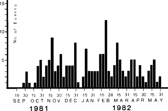 |
Figure 2. Number of volcanic earthquakes recorded 25 September 1981 through 31 May 1982 by a 3-station seismic net at Guagua Pichincha. Courtesy of M. Hall. |
Preliminary analysis of data from the 3-station seismic net shows hypocenters concentrated in two areas, both at roughly 4-5 km depth. Most of the events (maximum magnitude about 1) were centered 5-7 km SE of the summit, but some occurred below the caldera.
A geologist climbed to the summit 10 June and observed phreatic explosion deposits not present during the 16 May visit. The explosion appeared to have been directed toward the N, where ash coated recently stripped tree trunks to a maximum thickness of 5 cm. Ash deposition was followed by ejection of blocks up to 1 m across that produced impact craters as much as 4 m in diameter and 1.5 m deep. A zone of intense cratering extended 150 m from the vent and blocks 20 cm across were found as far as 350 m away. Hall's field work in the caldera 26-27 June revealed no evidence of additional explosions. No fracturing or other indications of uplift were observed on the top of the lava dome. Fumarole vapors had very little odor and were less voluminous than in previous visits. The 26-27 June visit followed three days without precipitation on the normally damp summit, and Hall is investigating the correlation between local rainfall and steam emission.
Further Reference. Salazar Medina, E., 1985, Riesgo volcánico de los volcanes Guagua Pichincha, Cotopaxi, y Tungurahua: Riesgo Volcánico en el Ecuador, INEMIN, Ministerio de Recursos Naturales, Quito, p. 1-24.
Geological Summary. Guagua Pichincha and the older Pleistocene Rucu Pichincha stratovolcanoes form a broad volcanic massif that rises immediately W of Ecuador's capital city, Quito. A lava dome grew at the head of a 6-km-wide scarp formed during a late-Pleistocene slope failure ~50,000 years ago. Subsequent late-Pleistocene and Holocene eruptions from the central vent consisted of explosive activity with pyroclastic flows accompanied by periodic growth and destruction of the lava dome. Many minor eruptions have been recorded since the mid-1500's; the largest took place in 1660, when ash fell over a 1,000 km radius and accumulated to 30 cm depth in Quito. Pyroclastic flows and surges also occurred, primarily to then W, and affected agricultural activity.
Information Contacts: M. Hall, Instituto Geofísico de la Escuela Politécnica Nacional.