Report on Rabaul (Papua New Guinea) — August 1982

Scientific Event Alert Network Bulletin, vol. 7, no. 8 (August 1982)
Managing Editor: Lindsay McClelland.
Rabaul (Papua New Guinea) Uplift, shallow seismicity continue 10-year increase
Please cite this report as:
Global Volcanism Program, 1982. Report on Rabaul (Papua New Guinea) (McClelland, L., ed.). Scientific Event Alert Network Bulletin, 7:8. Smithsonian Institution. https://doi.org/10.5479/si.GVP.SEAN198208-252140
Rabaul
Papua New Guinea
4.2459°S, 152.1937°E; summit elev. 688 m
All times are local (unless otherwise noted)
"The results of geophysical surveillance in Rabaul caldera since the early 1970's have been forming an intriguing scenario which can be interpreted as the prelude to an eruption.
"Seismic surveillance began in Rabaul in 1940 but it was not until 1967, when a network of seismic stations was installed around the N part of Blanche Bay (figure 1), that a reasonable appreciation of local seismicity became possible. Since that time, the apparent seismicity of Rabaul caldera has consisted essentially of shallow, short-period, volcano-tectonic earthquakes originating from about 6 km to near-surface depths. Other, longer-period, harmonic events of possibly local origin are much less common.
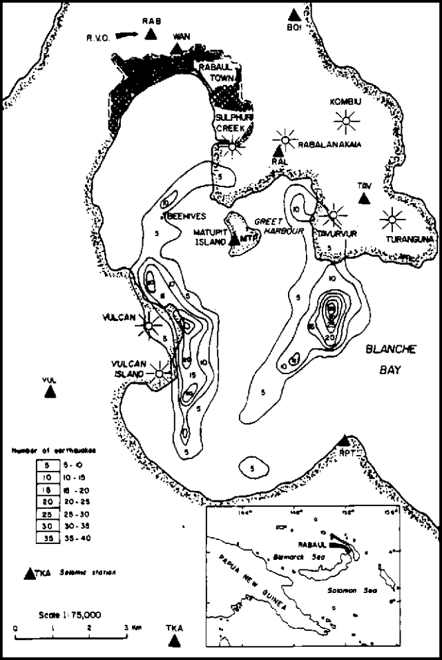 |
Figure 1. Pattern of seismicity in Rabaul Caldera, February 1977-June 1982. Solid triangles represent seismic stations (including the RVO), sunbursts represent volcanic centers. Isoseismal lines show numbers of earthquakes as listed in the table. |
"In the early 1970's, the seismic network was extended S and now consists of 9 stations. As the most sensitive stations of the present network are some of those established in 1967, a consistent appreciation of the frequency of occurence of caldera earthquakes is therefore possible. Between 1967 and 1971 seismicity of the caldera was quite stable and the rate of occurrence of local earthquakes varied from about 20 to slightly more than 100 events per month (figure 2). Since late 1971, distinctly higher numbers of earthquakes have been registered in what have come to be recognized as swarms of caldera earthquakes. Typically, these swarms last for periods of about 10 minutes to several hours in which individual earthquakes may occur at such short intervals that resolution on seismograms is commonly prevented.
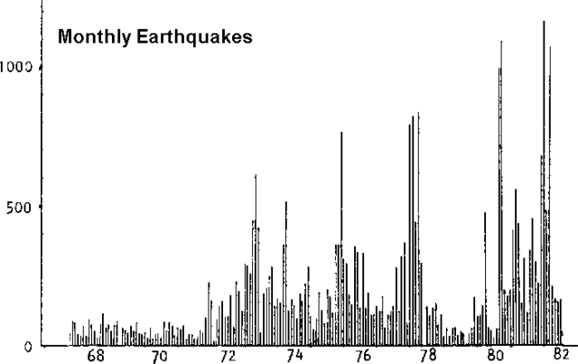 |
Figure 2. Rabaul Caldera seismicity, showing monthly numbers of earthquakes, 1967-82. |
"Figure 2 clearly shows the effects of a number of highly active periods (seismic crises) since 1971, in which sequences of seismic swarms took place. A trend of progressively higher numbers of events in successive seismic crises is discernable. In the two most recent crises, in September-October 1980 and January-March 1982, the strongest earthquakes registered at ML 5.2 and 5.1 respectively.
"A clear picture of the seismically active parts of Rabaul Caldera has emerged for the period 1977-1982, for which computer locations of caldera earthquakes have been obtained. A majority of the events located in this period have been shallow ones within about 2 km of the surface. In practice, the computer-locatable proportion of the total number of detected caldera earthquakes is about 10%, as reliable locations are only achievable when events are registered on five or more stations of the network. A further 10-15% of the total of detected events are registered by the group of three stations MTP, RAL, and TAV, (figure 1) suggesting that these (smaller) events originate from the Greet Harbour area.
"The broad pattern of Rabaul caldera seismicity is seen to be two arcuate zones, near the mouth and in the W part of Blanche Bay. A markedly elongated concentration of seismicity skirts the headland formed by the historically active Vulcan-Vulcan Island volcanoes (active 1878 and 1937), and an intense zone of seismicity lies about 3 km S of Tavurvur volcano, also active historically (1767(?), 1791, 1878, 1937, and 1941-43). Other distinct concentrations within the main seismic zones lie near the Beehives and in the Greet Harbour area. The shape of the main zones combined could be linked to a major, caldera-modifying eruption about 1300 BP; that is, the seismicity may define the fault(s) along which caldera deepening or widening took place. In addition, there appears to be an intimate relationship between the most recently active volcanoes in the caldera and some of the concentrations of seismicity. The most notable of these associations is in the Vulcan-Vulcan Island area, and weaker seismic zones appear to be related to Tavurvur (Greet Harbour) and the Beehives. The zone of strongest seismicity, near the entrance to Blanche Bay, is not closely associated with any well-known centres, although there is some evidence suggesting the possible existence of several submarine volcanoes nearby. Some clarification of these relationships and interpretations is provided by the results of deformation studies.
"The methods used to monitor deformation in Rabaul caldera include routine tiltmetry, optical levelling, gravity measurements, and sea level monitoring. Remarkable deformation in the Sulphur Creek-Matupit Island area has been monitored closely since 1973, principally by optical levelling and gravity techniques. Since 1973, the S end of Matupit Island has been uplifted almost 1 m. Figure 3 shows the results of optical levelling surveys carried out since 1973 along a line from a stable bench mark (BM 21) near Rabaul Observatory to Matupit Island. It appears that along this level line, elevation changes are only significant S of Sulphur Creek. Other incomplete levelling data on stations immediately N and 1-2 km E and SE of Greet Harbour indicate that over the same time interval, minor uplift, probably less than 10 cm, has occurred in these areas. However, significant uplift is believed to have taken place at the SW coast of Tavurvur volcano. Partial contours defining these changes indicate that the focus of uplift probably lies S of the entrance to Greet Harbour. Results from dry tiltmetry around Greet Harbour since early 1981 and measurements from a spirit level tiltmetry at TAV seismometer site since early 1972 confirm the existence of an uplift source in this area. Dry tilt data from a station on the S end of Matupit Island indicate a current rate of uplift (to the SE) of about 4-8 µrad per month. Level and gravity results from the W and S shores of Blanche Bay indicate relatively minor uplift there.
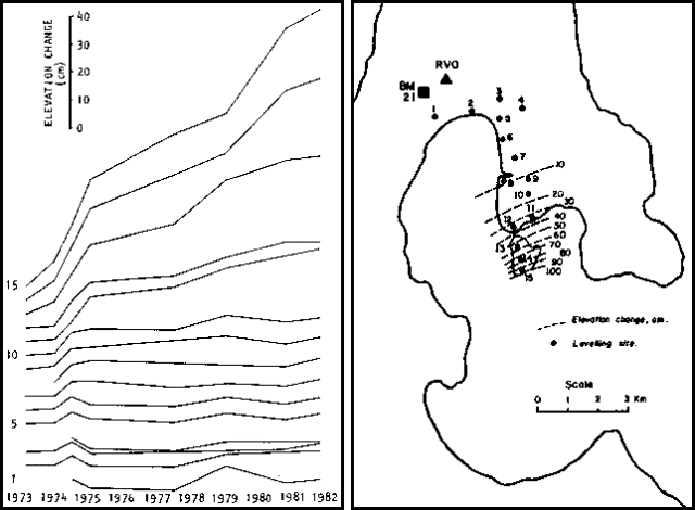 |
Figure 3. Elevation changes at Rabaul, 1973-82, S of RVO. Left: Results of optical levelling on gravity network stations. Elevation changes for each station are relative to the first measurement for each station (left end of each line) and can be read from the vertical scale in the upper left corner. Right: Map showing gravity network stations used as leveling sites and partial contour lines of elevation changes relative to stable benchmark BM 21. |
"The localized nature of the strongly deformed area is indicative of a shallow source of inflation. Preliminary determinations, comparing the uplift over different time intervals, suggest a focal depth of about 1-3 km. A noteworthy feature of the level changes shown in figure 3 is the steady rate of deformation. These aspects of the uplift suggest that the focus of the deformating source is relatively static in a vertical sense and that the deformation may be due to enlargement of the source.
"The developments in seismicity and deformation in Rabaul caldera appear ominous, although the rate of change in each of these parameters is steady, indicating a slowly evolving situation. It appears that uplift of Matupit Island was taking place before the regular program of gravity and levelling surveys commenced in 1973, but the time of onset of this effect is not known. A tiltmeter at Rabaul Observatory underwent a net change of about 40 µrad of southwards uplift between 1964 and 1981, but a tiltmeter at Sulphur Creek, much closer to the present focus of deformation, has shown a complex record of SW uplift since its installation in 1972. The seismicity has a much clearer history, with unequivocal changes commencing in late 1971.
"Significantly, the centroid of the two arcuate seismic zones has a similar location to the epicentre of the deformation. It could be concluded that the seismic zones outline a rising area in agreement with the known deformation. A possible cause for this apparently related activity could be accumulation of magma at shallow depth beneath the centre of Blanche Bay. This may eventually lead to an eruption."
Further Reference. Cooke, R.J.S, 1977, Rabaul Volcanological Observatory and geophysical surveillance of the Rabaul volcano: The Australian Physicist, Feb. 1977, p. 27-30.
Geological Summary. The low-lying Rabaul caldera on the tip of the Gazelle Peninsula at the NE end of New Britain forms a broad sheltered harbor utilized by what was the island's largest city prior to a major eruption in 1994. The outer flanks of the asymmetrical shield volcano are formed by thick pyroclastic-flow deposits. The 8 x 14 km caldera is widely breached on the east, where its floor is flooded by Blanche Bay and was formed about 1,400 years ago. An earlier caldera-forming eruption about 7,100 years ago is thought to have originated from Tavui caldera, offshore to the north. Three small stratovolcanoes lie outside the N and NE caldera rims. Post-caldera eruptions built basaltic-to-dacitic pyroclastic cones on the caldera floor near the NE and W caldera walls. Several of these, including Vulcan cone, which was formed during a large eruption in 1878, have produced major explosive activity during historical time. A powerful explosive eruption in 1994 occurred simultaneously from Vulcan and Tavurvur volcanoes and forced the temporary abandonment of Rabaul city.
Information Contacts: C. McKee, RVO.