Report on El Chichon (Mexico) — January 1983
Scientific Event Alert Network Bulletin, vol. 8, no. 1 (January 1983)
Managing Editor: Lindsay McClelland.
El Chichon (Mexico) Strong H2S emissions but no new explosions
Please cite this report as:
Global Volcanism Program, 1983. Report on El Chichon (Mexico) (McClelland, L., ed.). Scientific Event Alert Network Bulletin, 8:1. Smithsonian Institution. https://doi.org/10.5479/si.GVP.SEAN198301-341120
El Chichon
Mexico
17.3602°N, 93.2297°W; summit elev. 1150 m
All times are local (unless otherwise noted)
Scientists from UNAM's Instituto de Geofísica, Michigan Technological Univ., the Univ. of Maryland, and the USGS visited El Chichón 26-29 January 1983, the first time that observations were made within the active crater since the devastating March-April 1982 eruption. The expedition was made with helicopter support provided by the governments of the states of Tabasco and Chiapas. The following is from the scientific team's report.
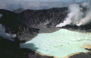
"The crater was geologically mapped and rocks and gases were sampled extensively. There was no evidence of any eruptive activity since at least 3 November, when excellent NASA photography was obtained. Extensive gas emission was still occurring from vents under and adjacent to the crater lake. The emissions were H2S-rich, apparently partly because the lake (temperature 52°C, pH 0.56) and the ground water were selectively extracting SO2. Most of the fumaroles were drowned by ground water, had temperatures between 90° and 115°C, and were audibly emitting steam. One fumarole on the SW side of the crater had a temperature of 446°C. The crater as a whole typically had H2S concentrations of 2-6 ppm, which required special precautions for the scientists. Seismic activity and landsliding were at a very low level.
"Geologic observations document two pre-1982 dome extrusion periods and two periods of pyroclastic flows in the crater wall stratigraphy, as well as domal units extruded on the somma or ring fracture around the crater.
"The level of the crater lake was receding of 2-3 cm/day during the period of observations. The high water mark of the lake coincided with the NASA flight in early November when it was 60 cm higher than in January. The recession correlated with a deepening of color in the lake and may in part have been due to the end of the rainy season."
Geological Summary. El Chichón is a small trachyandesitic tuff cone and lava dome complex in an isolated part of the Chiapas region in SE México. Prior to 1982, this relatively unknown volcano was heavily forested and of no greater height than adjacent non-volcanic peaks. The largest dome, the former summit of the volcano, was constructed within a 1.6 x 2 km summit crater created about 220,000 years ago. Two other large craters are located on the SW and SE flanks; a lava dome fills the SW crater, and an older dome is located on the NW flank. More than ten large explosive eruptions have occurred since the mid-Holocene. The powerful 1982 explosive eruptions of high-sulfur, anhydrite-bearing magma destroyed the summit lava dome and were accompanied by pyroclastic flows and surges that devastated an area extending about 8 km around the volcano. The eruptions created a new 1-km-wide, 300-m-deep crater that now contains an acidic crater lake.
Information Contacts: S. de la Cruz-Reyna, R. Mota P., and M. Mena J., UNAM, México; W. Rose, Jr., T. Bornhorst, S. Halsor, P. Plumley, and W. Capaul, Michigan Tech. Univ.; W. Zoller, Univ. of Maryland; T. Casadevall, USGS.