Report on Erebus (Antarctica) — March 1983

Scientific Event Alert Network Bulletin, vol. 8, no. 3 (March 1983)
Managing Editor: Lindsay McClelland.
Erebus (Antarctica) Lava lake level drops slightly; explosion earthquakes; earthquake swarm near area of 1908 thermal activity
Please cite this report as:
Global Volcanism Program, 1983. Report on Erebus (Antarctica) (McClelland, L., ed.). Scientific Event Alert Network Bulletin, 8:3. Smithsonian Institution. https://doi.org/10.5479/si.GVP.SEAN198303-390020
Erebus
Antarctica
77.53°S, 167.17°E; summit elev. 3794 m
All times are local (unless otherwise noted)
The following report from Juergen Kienle summarizes work by U.S., New Zealand, and Japanese scientists. "Surveillance of the activity associated with the anorthoclase phonolite lava lake continued during the 1982-83 austral field season. The summit crater was visited by New Zealand, U.S., and Japanese scientists on several occasions between November 1982 and February 1983. The approximately 100-m-long semicircular lava lake was still present. Its level had dropped by ~3 m, a loss of roughly 9,000 m3 of lava since the previous visit a year earlier. Since 1976, the lake area has stayed fairly constant. However, its level has been dropping at an average rate of ~2-3 m over the past 4 years.
"An original tripartite array of short-period seismic stations was installed in December 1980. During the 1981-82 field season, this array was expanded by two stations. All stations have single-component vertical seismometers. The summit station also transmits acoustic data to monitor explosive gas discharge from the lava lake. Another data channel is used to monitor electromagnetic signals induced in a wire loop laid around the summit crater by the eruption of conducting magma in the static field of the earth.
"Over the past 2 years many of the microearthquakes we recorded were located immediately beneath the summit lava lake. For example, figure 3 shows the epicenters and hypocenters of events located between December 1981 and January 1982. All but one of these events were explosion earthquakes that positively correlated with acoustic and sometimes electromagnetic signals. Explosive gas discharges from the lava lake typically occurred 2-6 times per day. Observers living in the summit hut commonly reported hearing several explosions per day.
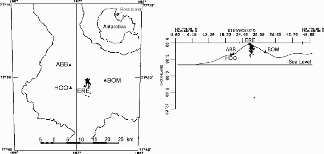 |
Figure 3. Locations (left) and E-W cross-section (right) of 75 earthquakes recorded 23 December 1981-18 January 1982 in map view. All shallow (<3 km) events were associated with an acoustic signal. Large triangles indicate positions of seismic stations. Inset shows the position of Ross Island. New determination of the velocity structure of Mt. Erebus will cause significant revision in earthquake locations. |
"Over the past 2 years we have also recorded microearthquake swarms that show a negative correlation with acoustic and electromagnetic signals. Typical daily counts of about 20 events during quiet periods rise by factors of about 5-10 in swarm periods. Again, most of these events were located beneath the summit region at depths shallower than 3 km.
"On 8 October 1982 an unusual earthquake swarm was recorded from a new source region on Ross Island. On that day almost 700 events occurred near Abbott Peak, a station 10 km NNE of the summit of Mt. Erebus. At this time we do not have reliable magnitudes for the events, but the fact that some of them were recorded at Scott Base and Mt. Terror suggest that the largest events had a local magnitude of 2-3. Figure 4 shows epicenters and a hypothetical cross section of the October events. It is interesting to note that the epicentral area is located halfway between Mt. Bird and Mt. Erebus and roughly correlates with an area that apparently was hydrothermally active in 1908. T.W. Edgeworth, David R. Priestley, and J. Murray, all members of the 1908 Shackelton expedition, reported steam clouds in April 1908 and a major steam eruption ('geysir') on 17 June 1908, rising from a source region at the 600-m level on the SSW slope of Mt. Bird. A tall jet of steam erupted from the same place on 8 September 1908. Philip Kyle has investigated rock outcrops in this area in recent years but could not find any sign of hydrothermal activity. The 8 October earthquake swarm may be related to renewed magma movement (dike injection?) at depth between Mt. Erebus and Mt. Bird. Preliminary hypocentral determinations suggest a clustering of events at 12-15 km depth. [Data compiled] by the Japanese participants in the International Mt. Erebus Seismic Study (IMESS) [included] the number of earthquakes recorded per hour and day at Abbott Peak, September-November 1982. On 8-9 October, the Abbott seismic station also recorded volcanic tremor from presently unknown depths."
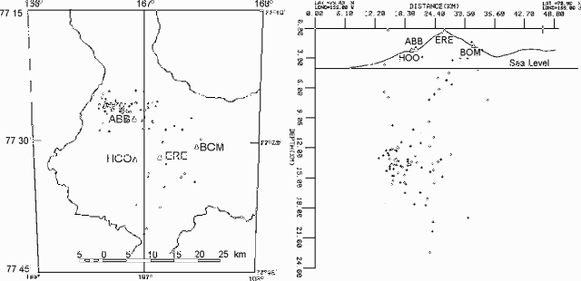 |
Figure 4. Epicenters of 92 earthquakes recorded at Erebus during 4-13 October 1982 in map view (left) and E-W cross section (right). New determination of the velocity structure of Mt. Erebus will cause significant revision in earthquake locations. |
Geological Summary. Mount Erebus, the world's southernmost historically active volcano, overlooks the McMurdo research station on Ross Island. It is the largest of three major volcanoes forming the crudely triangular Ross Island. The summit of the dominantly phonolitic volcano has been modified by one or two generations of caldera formation. A summit plateau at about 3,200 m elevation marks the rim of the youngest caldera, which formed during the late-Pleistocene and within which the modern cone was constructed. An elliptical 500 x 600 m wide, 110-m-deep crater truncates the summit and contains an active lava lake within a 250-m-wide, 100-m-deep inner crater; other lava lakes are sometimes present. The glacier-covered volcano was erupting when first sighted by Captain James Ross in 1841. Continuous lava-lake activity with minor explosions, punctuated by occasional larger Strombolian explosions that eject bombs onto the crater rim, has been documented since 1972, but has probably been occurring for much of the volcano's recent history.
Information Contacts: J. Kienle and D. Marshall, Univ. of Alaska; P. Kyle, New Mexico Inst. of Mining. & Tech.; K. Kaminuma, Nat. Inst. of Polar Research, Tokyo; R. Dibble, Victoria Univ., Wellington, New Zealand.