Report on Etna (Italy) — May 1983
Scientific Event Alert Network Bulletin, vol. 8, no. 5 (May 1983)
Managing Editor: Lindsay McClelland.
Etna (Italy) Lava production slows; lava partially diverted; central crater explosions continue; self-potential data
Please cite this report as:
Global Volcanism Program, 1983. Report on Etna (Italy) (McClelland, L., ed.). Scientific Event Alert Network Bulletin, 8:5. Smithsonian Institution. https://doi.org/10.5479/si.GVP.SEAN198305-211060
Etna
Italy
37.748°N, 14.999°E; summit elev. 3357 m
All times are local (unless otherwise noted)
The continuing eruption showed signs of a progressive decline on some days. The velocity of the lava flow from the vent at about 2,280 m altitude decreased from ~1.7 m/s on 28 May to <0.5 m/s in early June, with a reduction in the rate of outflow to ~3 m3/s. In early May, the velocity at the vent had been about 2 m/s and the effusion rate was about 10 m3/s. New flows, most of which moved S and SW, continued to add to the S flank lava field that has accumulated during the eruption. On 25 May a flow advanced beyond the edge of the lava field, reaching 1,240 m altitude by the 27th, ~5.5 km from the vent. From 28 May, all of the lava flowed toward the interior of the lava field or approached its W side. In early June, frequent and impressive overflows occurred from both sides of the main lava channel at about 2,200 m altitude. Within the lava field, effusive pseudo-vents at around 1,800-1,980 m altitude have remained numerous. As of 8 June the area covered by lava was estimated at 6 km2 and the volume of lava produced by the eruption was ~75-80 x 106 m3.
Explosions of varying intensity continued, particularly from Bocca Nuova and primarily ejected reddish ash. On 15 May and 1-4 June the explosions were quite large. A NOAA 7 satellite image at 1529 on 15 May showed a strong plume (as large or larger than the 4 May plume; 8:04) that extended 100-150 km to the SE. Pilots reported that the plume had emerged from the summit area at about 1100. on 1 June at 0800, pilots estimated the height of a plume at about 5 km and reported that it was drifting SSE. In May and early June, only vapor emission was observed from an explosion crater at 2,700 m altitude and a fissure between 2,450 and 2,300 m altitude that were active early in the eruption. On 3 June, deep felt shocks (M 3.3) occurred near the active vent; these events continued the next day.
Because the advancing lava flows threatened additional property damage, efforts were made to divert the lava. Explosive charges were detonated at 0409 on 14 May to blast a passage from the W side of the main lava flow at 2,100 m altitude into a previously prepared artificial channel. Initially 20% of the total lava flux was diverted into the artificial channel, but by 16 May lava had ceased to flow in this channel after reaching 700 m length. After the explosions, however, there were numerous substantial overflows from the main natural channel, particularly from the W side, and these slowed the advance of the most distant flow. Artificial embankments have also been constructed E and W of the main natural channel, allowing control of the overflows from this channel that were moving over earlier flows.
Pham Van Ngoc and D. Boyer obtained self potential data during a PIRPSEV mission to Etna 27 April to 3 May. The following is a report from Pham Van Ngoc.
"Five self potential (SP) profiles were carried out from 2,350 to 2,700 m elevation. These profiles straddled the open fissure that trends NNE-SSW below Piccolo Rifugio (at 2,500 m altitude on the S flank) and the N-S fractures above it. The profiles were located upstream from the lava emerging at 2,320 m altitude. Figure 12 shows the results of the SP profiles.
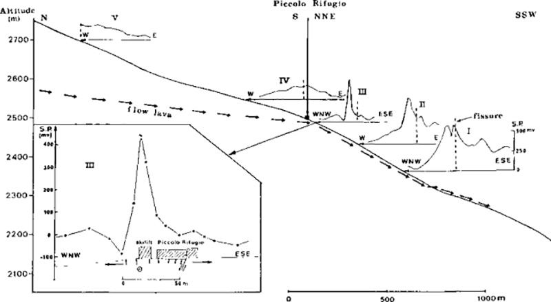 |
Figure 12. Results of self potential profiles obtained 27 April-3 May across open fractures that trended N-S above 2,500 m altitude (Piccolo Rifugio) and NNE-SSW (about 200° azimuth) below 2,500 m. The topographic profile (vertical exaggeration 2:01) parallels the fissure trends, changing strike at Piccolo Rifugio. Arrows pointing left show positions of self-potential profiles. Arrows pointing right diagrammatically show the inferred subsurface flow of magma, its emergence from the vent at 2,320 m altitude, and continuation downslope as flowing lava. The inset at lower left details profile III, indicating that the axis of the subsurface flow was under the ski lift building, 40 m W of the open fissure. Here arrows show local stress field and fault movement. Courtesy of Pham Van Ngoc. |
"The shape of the SP anomalies was very different S and N of Piccolo Rifugio. To the S, profiles I, II, and III show huge (more than 50 mV) and sharp anomalies suggestive of superficial origin. it is notable that the maxima of these anomalies were not located just above the open fissure, but 40-50 m westward. The detail of profile III, just below Piccolo Rifugio, indicated clearly that the axis of the underground flow lies 40 m W of the active fissure (under the ski lift building W of Piccolo Rifugio). These results confirm that the pressure exerted by underground flow induced an E-W extension, creating a small graben clearly visible in the area of Piccolo Rifugio. The open fissure corresponds to a normal fault on the E edge of the graben and caused the collapse of the W part of Piccolo Rifugio.
"Above Piccolo Rifugio, profiles IV and V show much smaller Sp anomalies (~250 mV). Furthermore, these anomalies widen, thus indicating a deeper origin. It is notable that the shape of the SP anomalies changed completely from profile III to profile IV in a distance of ~300 m.
"SP results suggest that: 1) above Piccolo Rifugio, the magma flowed deeply in a N-S direction; and 2) level with Piccolo Rifugio (2,500 m altitude), the magma suddenly approached the surface and followed a shallow underground NNE-SSW channel that ran some 50 m W of the open fissure, then came to the surface at about 2,320 m altitude. Arrows in figure 12 indicate the path inferred from the lava."
Geological Summary. Mount Etna, towering above Catania on the island of Sicily, has one of the world's longest documented records of volcanism, dating back to 1500 BCE. Historical lava flows of basaltic composition cover much of the surface of this massive volcano, whose edifice is the highest and most voluminous in Italy. The Mongibello stratovolcano, truncated by several small calderas, was constructed during the late Pleistocene and Holocene over an older shield volcano. The most prominent morphological feature of Etna is the Valle del Bove, a 5 x 10 km caldera open to the east. Two styles of eruptive activity typically occur, sometimes simultaneously. Persistent explosive eruptions, sometimes with minor lava emissions, take place from one or more summit craters. Flank vents, typically with higher effusion rates, are less frequently active and originate from fissures that open progressively downward from near the summit (usually accompanied by Strombolian eruptions at the upper end). Cinder cones are commonly constructed over the vents of lower-flank lava flows. Lava flows extend to the foot of the volcano on all sides and have reached the sea over a broad area on the SE flank.
Information Contacts: R. Romano, IIV; Pham Van Ngoc, Ecole Nationale Supérieure de Géologie; M. Matson, NOAA.