Report on Veniaminof (United States) — May 1983

Scientific Event Alert Network Bulletin, vol. 8, no. 5 (May 1983)
Managing Editor: Lindsay McClelland.
Veniaminof (United States) Strombolian activity and lava flow from cone in ice-filled caldera
Please cite this report as:
Global Volcanism Program, 1983. Report on Veniaminof (United States) (McClelland, L., ed.). Scientific Event Alert Network Bulletin, 8:5. Smithsonian Institution. https://doi.org/10.5479/si.GVP.SEAN198305-312070
Veniaminof
United States
56.17°N, 159.38°W; summit elev. 2507 m
All times are local (unless otherwise noted)
Pilots began to report eruption clouds from Veniaminof late 4 June, noting that plumes containing some ash rose to about 4.5 km altitude. Residents of Perryville (population 100, about 25 km S of the volcano) saw incandescence and dark skies on 7 June at about 0130. Later that day, USGS personnel flew over Veniaminof. In the S part of the 10-km-diameter, ice-filled caldera, Strombolian activity was occurring from two vents on a cone that rises about 300 m above the ice and had previously been the site of fumarolic activity. Cherry-red molten material was ejected several times per minute to roughly 30-60 m height. The lowest 150 m of the eruption column was tephra-rich, but above that height the plume was wispy and light gray. About 50 km2 of ice, chiefly to the S and SW, was coated with a very thin layer of ash. In the ice just SE of the cone, a prominent set of ring fractures defined a circular depression, produced by melting, that was estimated to be about 0.5 km in diameter and no more than 20 m deep.
By the next USGS overflight, at 1500 on 9 June, Strombolian activity was more vigorous and lava was flowing down the S side of the cone. Bombs and scoria were ejected every 3-5 seconds to about 2400 m altitude, about 250 m above the summit of the cone. Tephra had begun to fill the cone's crater and an increasing number of bombs were falling on its flanks. Lava flowed from the summit down the steeply sloping S side of the cone onto the ice field, where a large E-W-trending dumbbell-shaped depression had formed. Lava flowed into the W part of the dumbbell and sank into the ice, from which billowing clouds of steam were rising. The base of the lava flow was roughly 100 m in diameter. Open water was present in the narrow area between the two parts of the dumbbell, and the E part was characterized by an unusual fracture pattern. The E part of this feature closely approached, but did not touch, the depression in the ice observed 2 days earlier. The timing of the beginning of lava flow activity was uncertain, but a pilot who flew past the volcano at 1330 on 8 June saw no steam clouds, so lava probably had not begun to flow onto the ice by then.
A short-period seismic instrument located at Ivanof Bay, about 30 km from the volcano, was operating in its standard event-triggered mode until it was reset to record continuously 8 June. Between 8 and 10 June, it recorded nearly continuous low-amplitude tremor, with occasional larger discrete bursts that reached (preliminary) magnitudes of 1-2 (figure 1). No unusual discharge from streams draining the caldera has been observed. An eruption from Veniaminof was last reported in 1944 [but see 8:6].
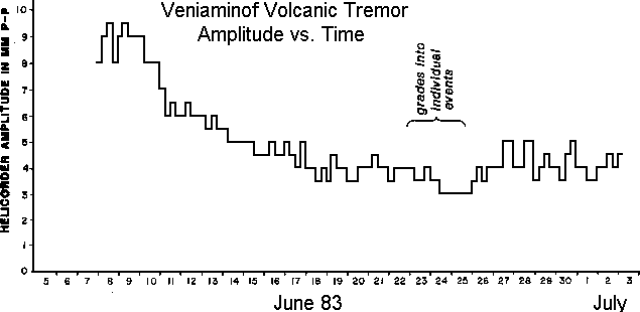 |
Figure 1. Volcanic tremor amplitude vs. time, 8 June-2 July 1983. Station IVF (Ivanof Bay) has a 1-Hz vertical geophone and is located 31 km SSW of the volcano's summit. The signal is radio-telemetered to a central recording site and is recorded on both an event-triggered digital system and on a helicorder. The plot shows the helicorder amplitude of the approximately 1.2 Hz volcanic tremor at 6-hour intervals; measurements were taken for the peak-to-peak waveform with an amplitude that was attained or exceeded at least three times during the 6-hour period. On 23-24 June the signal changed gradually from continuous tremor of variable amplitude to discrete individual events (dates are GMT). Courtesy of Stephen McNutt. [Originally appeared in 8:8.] |
Geological Summary. Veniaminof, on the Alaska Peninsula, is truncated by a steep-walled, 8 x 11 km, glacier-filled caldera that formed around 3,700 years ago. The caldera rim is up to 520 m high on the north, is deeply notched on the west by Cone Glacier, and is covered by an ice sheet on the south. Post-caldera vents are located along a NW-SE zone bisecting the caldera that extends 55 km from near the Bering Sea coast, across the caldera, and down the Pacific flank. Historical eruptions probably all originated from the westernmost and most prominent of two intra-caldera cones, which rises about 300 m above the surrounding icefield. The other cone is larger, and has a summit crater or caldera that may reach 2.5 km in diameter, but is more subdued and barely rises above the glacier surface.
Information Contacts: T. Miller, USGS, Anchorage; S. McNutt, LDGO.