Report on Veniaminof (United States) — July 1983

Scientific Event Alert Network Bulletin, vol. 8, no. 7 (July 1983)
Managing Editor: Lindsay McClelland.
Veniaminof (United States) Lava flow melts large pit in caldera ice, then eruption weakens
Please cite this report as:
Global Volcanism Program, 1983. Report on Veniaminof (United States) (McClelland, L., ed.). Scientific Event Alert Network Bulletin, 8:7. Smithsonian Institution. https://doi.org/10.5479/si.GVP.SEAN198307-312070
Veniaminof
United States
56.17°N, 159.38°W; summit elev. 2507 m
All times are local (unless otherwise noted)
The eruption remained vigorous through mid-July, but appeared to be declining in late July and early August. During an overflight on 13 July, the active cinder cone filled most of the summit crater of the pre-existing intra-caldera cone. From a breach in the S side of the cinder cone, molten material was ejected every 1-2 minutes to 150-300 m height. A blocky lava flow 15-20 m wide moved from the breach down the slope of the intra-caldera cone and ponded at the bottom of a vertically walled ice pit about 1,600 m long, 400-800 m wide and 60-100 m deep. The pit, elongate roughly E-W with a slight curvature to the N at its E end, appeared to result from coalescence of smaller ice pits observed in mid-June. It contained a water lake of unknown depth, and white vapor columns rose from the vicinity of the lava flow. The active cone also emitted a thin discontinuous brown-gray eruption column that rose to about 4.2 km altitude, feeding a long narrow plume that extended 30 km or more ENE. Additional tephra had been deposited inside and outside the caldera since the previous month's observations.
Although lava continued to flow down the S side of the cone on 26 July, activity appeared weaker. Yellow sublimates were observed around the vent. By the next overflight, on 3 August, no incandescent tephra was being ejected and the lava flow did not appear to be moving. A few bright reddish-brown patches were noted along the lower part of the flow, but it was not possible to determine whether these were incandescent areas or heavily oxidized zones. Yellow sublimates were visible on the N portion of the active cone and the upper part of the lava flow. The nose of the flow was steaming, especially where it was in contact with the ice pit's meltwater lake (figure 4). The flow had advanced farther into the ice pit and was within 50 m of dividing the meltwater lake into two parts. No ice was seen falling into the lake, but its S portion was ice-choked. Concentric fractures extended SW from the lake almost to the caldera rim. Ash covered the entire caldera, the slopes outside its rim, and mountains to the S. Glacier ice outside the caldera was colored light chocolate brown by ash. Three fissures, not visible on a 7 June airphoto, extended from an older cinder cone in the N-central part of the caldera about a quater of the way to the active cone 2.5 km to the SW.
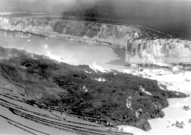 |
Figure 4. Photograph taken 3 August 1983 showing the nose of the lava flow in the ice pit. Note the concentric fractures in the ice near the edge of the pit. Dark ash covers the ice surface. Courtesy of Steven Nelson. |
Geological Summary. Veniaminof, on the Alaska Peninsula, is truncated by a steep-walled, 8 x 11 km, glacier-filled caldera that formed around 3,700 years ago. The caldera rim is up to 520 m high on the north, is deeply notched on the west by Cone Glacier, and is covered by an ice sheet on the south. Post-caldera vents are located along a NW-SE zone bisecting the caldera that extends 55 km from near the Bering Sea coast, across the caldera, and down the Pacific flank. Historical eruptions probably all originated from the westernmost and most prominent of two intra-caldera cones, which rises about 300 m above the surrounding icefield. The other cone is larger, and has a summit crater or caldera that may reach 2.5 km in diameter, but is more subdued and barely rises above the glacier surface.
Information Contacts: T. Miller, M.E. Yount, S. Nelson, and R. Emanuel, USGS, Anchorage.