Report on Teahitia (France) — August 1983

Scientific Event Alert Network Bulletin, vol. 8, no. 8 (August 1983)
Managing Editor: Lindsay McClelland.
Teahitia (France) Shallow earthquakes and high-frequency tremor
Please cite this report as:
Global Volcanism Program, 1983. Report on Teahitia (France) (McClelland, L., ed.). Scientific Event Alert Network Bulletin, 8:8. Smithsonian Institution. https://doi.org/10.5479/si.GVP.SEAN198308-333010
Teahitia
France
17.564°S, 148.821°W; summit elev. -1743 m
All times are local (unless otherwise noted)
Between 11 and 20 July, the RSP recorded 3,000-4,000 shallow earthquakes at Teahitia, accompanied by high-frequency volcanic tremor (figure 2).
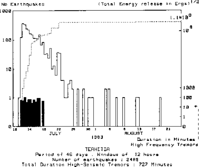 |
Figure 2. Seismicity near Teahitia during 10 July-24 August 1983. Number of recorded earthquakes at 12-hour intervals (solid line), duration of high-frequency tremor in minutes (bars), and cumulative seismic energy release (dashed line, log scale). Courtesy of J. Talandier. |
Geological Summary. Teahitia is a submarine volcano in the Society Islands whose summit reaches to within ~1,700 m of the surface, 40 km NE of the SE tip of Tahiti Island. Several seismic swarms in the 1980s included volcanic tremor that may have resulted from submarine eruptions (Talandier and Opal, 1984). Rocks dredged in 1986 "exploded" when they reached the surface, suggesting recent lava extrusion that had not yet had time to equilibrate with pressure and temperature conditions on the submerged flanks of the edifice. Two hydrothermal fields each about 400 x 1,000 m exhibiting low-temperature hydrothermal venting were discovered on the flanks during submersible dives in 1986 and 1989.
Information Contacts: J.M. Talandier, Lab. de Géophysique, Tahiti.