Report on Veniaminof (United States) — January 1984

Scientific Event Alert Network Bulletin, vol. 9, no. 1 (January 1984)
Managing Editor: Lindsay McClelland.
Veniaminof (United States) Lava fountains and flow continue
Please cite this report as:
Global Volcanism Program, 1984. Report on Veniaminof (United States) (McClelland, L., ed.). Scientific Event Alert Network Bulletin, 9:1. Smithsonian Institution. https://doi.org/10.5479/si.GVP.SEAN198401-312070
Veniaminof
United States
56.17°N, 159.38°W; summit elev. 2507 m
All times are local (unless otherwise noted)
Perryville residents observed glow over the summit of the volcano during the evenings of 31 December, and 3, 4, 11, and 13 January. Activity intensified on 17 January, when they observed lava fountains as high as 200 m. The fountains were active for 30-45-minute periods, waned for indefinite intervals, then resumed.
During an overflight by USGS personnel between 1345 and 1410 on 23 January, billowing white vapor clouds rose from the summit area of the intra-caldera cone to approximately 3-4 km altitude and were blown E (figures 5 and 6). There was no ash in the eruption plume or on the area surrounding the cone. Fountains rose 10-20 m and lava flowed from a vent about 100 m below the summit of the cinder cone that has grown during the eruption to nearly fill the crater of the intra-caldera cone. The lava flow, estimated at 10-20 m wide, was confined by steep levees and extended more than 200 m onto the lava delta formed by earlier flows that covered the entire floor of the ice pit. Although the surface of the lava delta was irregular, its average thickness was estimated at about 30 m. USGS personnel estimated that approximately 45 x 106 m3 of lava has filled the ice pit since June.
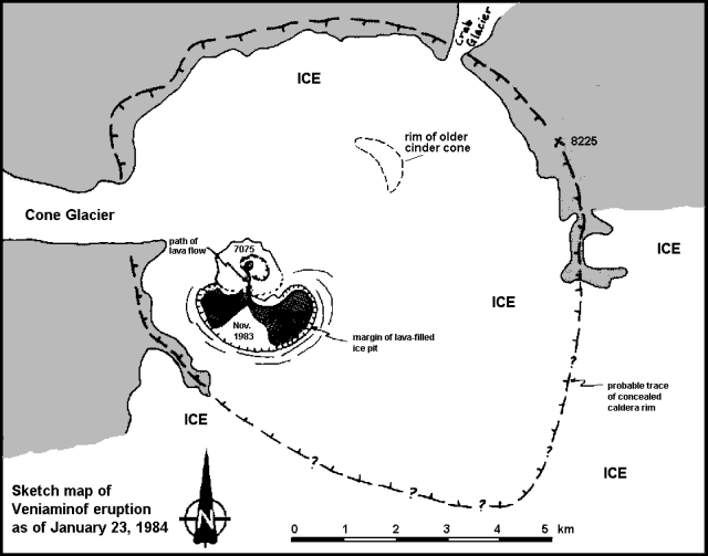 |
Figure 5. Sketch map by M. Elizabeth Yount of Veniaminof on 23 January 1984. The intra-caldera cone, lava-filled ice pit, and lava flows of November and January are shown. See figure 2 for comparison. |
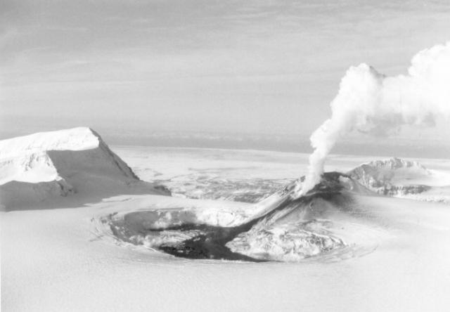 |
Figure 6. Photograph of Veniaminof from the SE taken 23 January 1984. A vapor plume rises from the new cinder cone built within the summit crater of the intra-caldera cone. Steam rises from the perimeter of the ice pit where lava contacts ice. Courtesy of M. Elizabeth Yount. |
The ice pit had increased in size since the last overflight on 4 November to more than 2 km by about 1 km (compare figures 5 and 2). Steam rose from numerous sites on the perimeter of the pit where lava contacted ice. Perryville residents observed a very large vapor cloud, but not much incandescent material, over the summit of the volcano 4-6 February. On the evening of the 6th, lava fountains rose to heights of several tens of meters for approximately half hour periods, separated by 45-minute intervals. On 7 February a small vapor cloud rose from the summit area, and that evening Perryville residents saw a faint glow but no lava fountains.
Geological Summary. Veniaminof, on the Alaska Peninsula, is truncated by a steep-walled, 8 x 11 km, glacier-filled caldera that formed around 3,700 years ago. The caldera rim is up to 520 m high on the north, is deeply notched on the west by Cone Glacier, and is covered by an ice sheet on the south. Post-caldera vents are located along a NW-SE zone bisecting the caldera that extends 55 km from near the Bering Sea coast, across the caldera, and down the Pacific flank. Historical eruptions probably all originated from the westernmost and most prominent of two intra-caldera cones, which rises about 300 m above the surrounding icefield. The other cone is larger, and has a summit crater or caldera that may reach 2.5 km in diameter, but is more subdued and barely rises above the glacier surface.
Information Contacts: M.E. Yount and T. Miller, USGS, Anchorage.