Report on El Chichon (Mexico) — March 1984
Scientific Event Alert Network Bulletin, vol. 9, no. 3 (March 1984)
Managing Editor: Lindsay McClelland.
El Chichon (Mexico) Plumes on satellite images not caused by eruptions
Please cite this report as:
Global Volcanism Program, 1984. Report on El Chichon (Mexico) (McClelland, L., ed.). Scientific Event Alert Network Bulletin, 9:3. Smithsonian Institution. https://doi.org/10.5479/si.GVP.SEAN198403-341120
El Chichon
Mexico
17.3602°N, 93.2297°W; summit elev. 1150 m
All times are local (unless otherwise noted)
Weather satellite images 3-4 April showed a series of plume-like features originating from the vicinity of El Chichón. Data from the TOMS instrument on the Nimbus-7 polar orbiting satellite 9.5 hours after the last plume observation showed no enhancement in SO2 over the area. However, cloud elevations were estimated at 13.5 km and this prompted an on-site investigation.
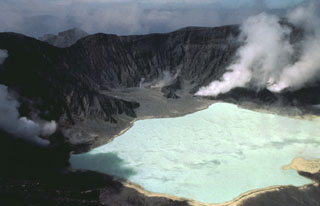
Servando de la Cruz visited the volcano and found no evidence that an eruption had occurred. There was no change in the appearance of the crater, crater lake, or outer flanks, and no sign of any recent tephra deposits. Since the 15 February visit, temperatures of the crater lake (36-37°C) and fumaroles (96-98°C) had declined slightly, and the crater lake level was somewhat lower after several weeks of very little rainfall. de la Cruz noted that smoke produced by the centuries-old practice of burning the remains of the corn plants after the harvest might have looked like eruption plumes on the satellite imagery, although corn is not the most common crop in the immediate vicinity of the volcano.
Geological Summary. El Chichón is a small trachyandesitic tuff cone and lava dome complex in an isolated part of the Chiapas region in SE México. Prior to 1982, this relatively unknown volcano was heavily forested and of no greater height than adjacent non-volcanic peaks. The largest dome, the former summit of the volcano, was constructed within a 1.6 x 2 km summit crater created about 220,000 years ago. Two other large craters are located on the SW and SE flanks; a lava dome fills the SW crater, and an older dome is located on the NW flank. More than ten large explosive eruptions have occurred since the mid-Holocene. The powerful 1982 explosive eruptions of high-sulfur, anhydrite-bearing magma destroyed the summit lava dome and were accompanied by pyroclastic flows and surges that devastated an area extending about 8 km around the volcano. The eruptions created a new 1-km-wide, 300-m-deep crater that now contains an acidic crater lake.
Information Contacts: S. de la Cruz-Reyna, UNAM; A. Krueger, NASA GSFC; M. Matson, NOAA/NESDIS; T. Casadevall and R.. Tilling, USGS.