Report on Oku Volcanic Field (Cameroon) — August 1984
Scientific Event Alert Network Bulletin, vol. 9, no. 8 (August 1984)
Managing Editor: Lindsay McClelland.
Oku Volcanic Field (Cameroon) Poisonous gas from Lake Monoun explosion kills 37
Please cite this report as:
Global Volcanism Program, 1984. Report on Oku Volcanic Field (Cameroon) (McClelland, L., ed.). Scientific Event Alert Network Bulletin, 9:8. Smithsonian Institution. https://doi.org/10.5479/si.GVP.SEAN198408-224030
Oku Volcanic Field
Cameroon
6.25°N, 10.5°E; summit elev. 3011 m
All times are local (unless otherwise noted)
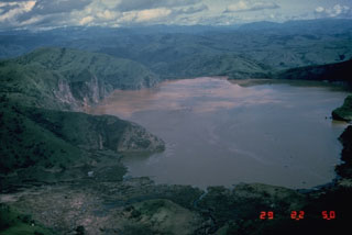
Before dawn on 16 August an explosion in Lake Monoun (~7 km [corrected from 1 km] from the village of Fuombot and 218 km NE of Mt. Cameroon) produced a 5-m water wave [shock waves and burned vegetation were originally reported by the embassy], flattening vegetation around the lake. A white cloud in the vicinity of the lake at daybreak looked like typical fog, but contained poisonous gas that killed 37 people. Victims suffered vomiting, paralysis, and very rapid death; some lost the outer layer of their skin. The Cameroon government sent a team of investigators to the scene, who collected samples of rock and damaged vegetation. Residents fled the area but most had returned to their homes within a few days. As of late August, the lake water was still reddish.
No previous eruptions are known from Lake Monoun. A 1:1,000,000 geologic map shows basalts and some rhyolites and trachytes in the area but the rocks are not dated (Le Marechal, 1975a). Lake Monoun is located at the intersection of an E-W trending zone of mylonites and the Cameroon Line (Le Marechal, 1975b), a chain of Tertiary to Recent generally alkaline volcanoes extending from Annobon Island in the Atlantic Ocean northeastward through Cameroon, dividing into two branches at its northeastern end (Fitton, 1980, and figure 1). Mt. Cameroon, the only known site of Recent volcanism along the Cameroon Line, last erupted October-November 1982. Rocks as old as 31 million years have been dated along the Cameroon Line (on Principe Island; Fitton, 1980).
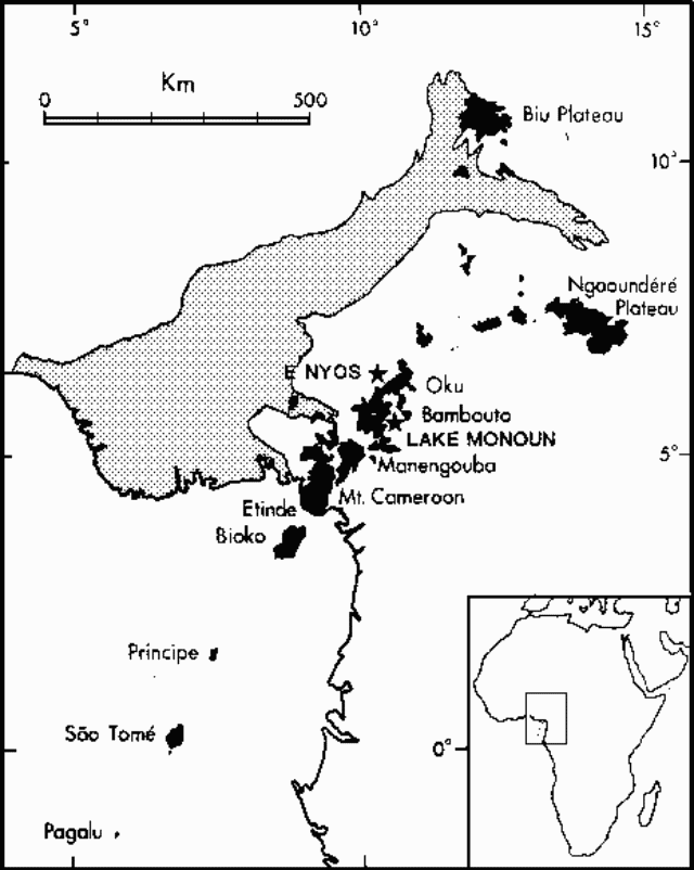 |
Figure 1. Map of the Cameroon Line and Benue Trough, after Fitton and Dunlop (1985). Volcanic rocks are shown in black. The approximate position of lakes Monoun and Nyos are indicated by stars. |
References. Fitton, J. G., 1980, The Benue Trough and Cameroon Line- a migrating rift system in West Africa: Earth and Planetary Science Letters, v. 51, p. 132-138.
Le Marechal, A., 1975a, Carte geologique de l'ouest du Cameroun et de l' Adamaoua, 1:1,000,000; ORSTOM.
Le Marechal, A., 1975b, Directions structurales de l'ouest du Cameroun et de l'Adamaoua, 1:1,000,000; ORSTOM.
Geological Summary. Numerous maars and basaltic cinder cones lie on or near the deeply dissected rhyolitic and trachytic Mount Oku massif along the Cameroon volcanic line. The Mount Oku stratovolcano is cut by a large caldera. The Oku volcanic field is noted for two crater lakes, Lake Nyos to the N and Lake Monoun to the S, that have produced catastrophic carbon-dioxide gas release events. The 15 August 1984 gas release at Lake Monoun was attributed to overturn of stratified lake water, triggered by an earthquake and landslide. The Lake Nyos event on 21 August 1986 caused at least 1,700 fatalities. The emission of ~1 km3 of magmatic carbon dioxide has been attributed either to overturn of stratified lake waters as a result of a non-volcanic process, or to phreatic explosions or injection of hot gas into the lake.
Information Contacts: C. Twining, American Embassy, Douala; Yaoundé Domestic Radio Service.