Report on Mayon (Philippines) — September 1984

Scientific Event Alert Network Bulletin, vol. 9, no. 9 (September 1984)
Managing Editor: Lindsay McClelland.
Mayon (Philippines) Explosive activity reintensifies; 73,000 evacuated
Please cite this report as:
Global Volcanism Program, 1984. Report on Mayon (Philippines) (McClelland, L., ed.). Scientific Event Alert Network Bulletin, 9:9. Smithsonian Institution. https://doi.org/10.5479/si.GVP.SEAN198409-273030
Mayon
Philippines
13.257°N, 123.685°E; summit elev. 2462 m
All times are local (unless otherwise noted)
Quoted material is from PHIVOLCS.
"Eruptive activity started 9 September at 1923. Initial activity was dominantly Strombolian, with incandescent spattering at the summit and production of small lava flows. A mound of solidified lava inside the crater blocked the 1968 notch at the SW rim, so the small lava flows and initial pyroclastic flows (see below) moved predominantly NW.
"A fairly strong eruption 10 September at 2300 marked the start of Vulcanian activity. Ash-laden steam clouds rose 5 km above the summit and a pyroclastic flow moved down to the NW, reaching 700 m elevation. Stronger explosions 11 September reopened the notch at the SW rim, so more of the later lava and pyroclastic flows moved SW than NW. The eruption continued to intensify, peaking 13 September. Cauliflower-shaped, ash-laden steam clouds accompanied by rumbling sounds reached a maximum height of 15 km before drifting SW, W, and NW. Continuous volcanic tremors with increasing amplitude were recorded, punctuated by explosion earthquakes. Two lava flows emerged through the SW breach. One reached 500 m elevation, adjacent to and W of the 1978 flow. The other, a little farther W, advanced to 1,400 m elevation (figure 2). The new lava is porphyritic augite-hypersthene andesite.
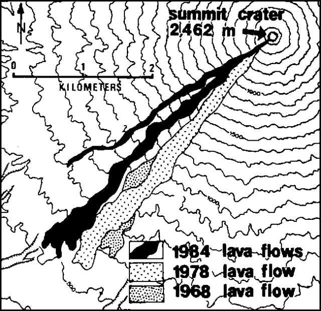 |
Figure 2. Map of Mayon showing the extent of the 1984 lava flows, after Corpuz (1985). |
"Activity gradually declined 14-21 September. A mild eruption 22 September at 0502 was accompanied by a volcanic earthquake felt at intensity II on the MRF scale at the Mayon Resthouse Observatory. A relatively quiet period followed. A very strong explosion 23 September at 0433 ejected voluminous ash-laden steam clouds that reached 10 km in height. Incandescent tephra rose 2 km above the summit and spread in all directions, covering the summit area with red-hot tephra to about 1,500 m elevation. A large notch was formed in the SE rim of the crater and a smaller one in the E rim. Subsequent pyroclastic flows were directed predominantly SE and E, although some moved in other directions along gullies. Ash fell within about 50 km SW, W, and NW of the summit. Areas E and NE of the volcano received most of the fine airfall tephra generated by pyroclastic flows. The eruption continued to intensify until the 24th. Voluminous ash emission, sometimes sustained for 5 minutes, occurred at intervals of 2-15 minutes, accompanied by strong detonations and at times by electrical discharges. Maximum height of the eruption clouds was 15 km. On 24 September at 1614, a nuée ardente [almost] reached the nearest village. A large volume of pyroclastic flow material was deposited on the SE flank. The eruption started to decline 25 September. By 5 October activity was limited to weak steaming and faint to moderate crater glow, accompanied by volcanic tremors and discrete earthquakes."
Press sources reported reintensification of the eruption 6 October. Ash-laden steam clouds rose as much as 1.7 km above the summit and lava flowed 1 km from the crater.
"Mudflows generated by rain destroyed three sections of the Legaspi-Santo Domingo highway roughly 8 km SE of the volcano. Larger mudflows on the 27th overran the same portion of highway. Two bridges were destroyed along the Malilipot-Santo Domingo highway, roughly 8 km E of Mayon."
As of 30 September, press sources reported that 6,500 hectares of farmland had been covered by mudflows.
"Implementation of the Mayon preparedness plan was fairly smooth. On 10 September, the area within 6 km of the summit was declared off-limits and all residents were recommended for evacuation. On 12 September, the danger zone was extended to 8 km from the summit on the S and SW flanks. About 26,000 people were evacuated during the first phase of the eruption. On 23 September, the danger zone was expanded again, to 10 km from the summit on the SE side and 8 km from the summit around the rest of the volcano. All residents of that area were recommended for evacuation and the number of evacuees swelled to more than 73,000 at 50 centers. No casualties were attributed directly to the eruption or mudflows."
Reference. Corpuz, E., 1985, Chronology of the September-October 1984 eruption of Mayon volcano, Philippines in Punongbayan, R.S. (ed.), 1985, Special issue on the 1984 eruption of Mayon: Philippine Journal of Volcanology, v. 2, p. 36-51 (9 papers, 205 p.).
Further Reference. Umbal, J., 1987, Recent lahars of Mayon volcano in Geologic hazards and disaster preparedness systems: National Science and Technology Authority, p. 56-76.
Geological Summary. Symmetrical Mayon, which rises above the Albay Gulf NW of Legazpi City, is the most active volcano of the Philippines. The steep upper slopes are capped by a small summit crater. Recorded eruptions since 1616 CE range from Strombolian to basaltic Plinian, with cyclical activity beginning with basaltic eruptions, followed by longer periods of andesitic lava flows. Eruptions occur predominately from the central conduit and have also produced lava flows that travel far down the flanks. Pyroclastic density currents and mudflows have commonly swept down many of the approximately 40 ravines that radiate from the summit and have often damaged populated lowland areas. A violent eruption in 1814 killed more than 1,200 people and devastated several towns.
Information Contacts: PHIVOLCS, Quezon City; DPA; AP.