Report on Campi Flegrei (Italy) — February 1985
Scientific Event Alert Network Bulletin, vol. 10, no. 2 (February 1985)
Managing Editor: Lindsay McClelland.
Campi Flegrei (Italy) Deflation continues and seismicity weak
Please cite this report as:
Global Volcanism Program, 1985. Report on Campi Flegrei (Italy) (McClelland, L., ed.). Scientific Event Alert Network Bulletin, 10:2. Smithsonian Institution. https://doi.org/10.5479/si.GVP.SEAN198502-211010
Campi Flegrei
Italy
40.827°N, 14.139°E; summit elev. 458 m
All times are local (unless otherwise noted)
"Activity at Campi Flegrei has decreased substantially after 2.5 years of continuous ground uplift and seismic activity. The tide gauge in Pozzuoli harbor measured 2 cm of ground subsidence during February (figure 8). Seismic activity remained at a very low level with only a few low-energy events in the Gulf of Pozzuoli. The periodic survey of the entire vertical deformation network was completed in January. An uplift of 3 cm since October 1984 was measured on the benchmark in the area of maximum deformation (figure 11).
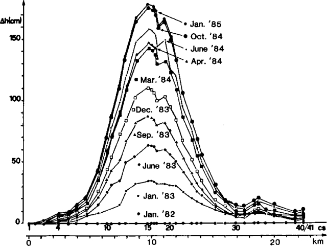 |
Figure 11. Results of 10 surveys of the levelling network at Campi Flegrei, January 1982-January 1985. Benchmarks are oriented along an approximately E-W line (see figure 1 for their locations). |
"Radon and temperature measurements are currently made in four water wells. The pattern of radon content of two of them, near Solfatara (Tortorelli well) and Monte Nuovo (Damiani well), shows good correlation (figure 12). At the present time, we observe high radon emission, similar to observations in the same period last year. The two years of continuous monitoring give evidence of a seasonal trend in radon emission.
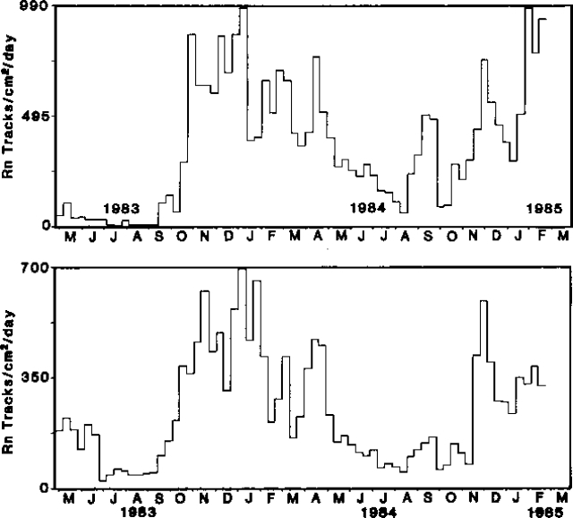 |
Figure 12. Results of radon measurements from two water wells at Campi Flegrei: top, near Solfatara, 26 April 1983-2 March 1985 (Tortorelli); bottom, near Monte Nuovo, 26 April 1983-25 February 198 (Damiani). Courtesy of OV. |
A possible increase, due to influx of hot fluids from depth, may have occurred December 1983-April 1984. During this period, a slight but significant increase in water temperature was observed (figure 13), which matches well with the period of highest seismic energy release. A more detailed study is under way.
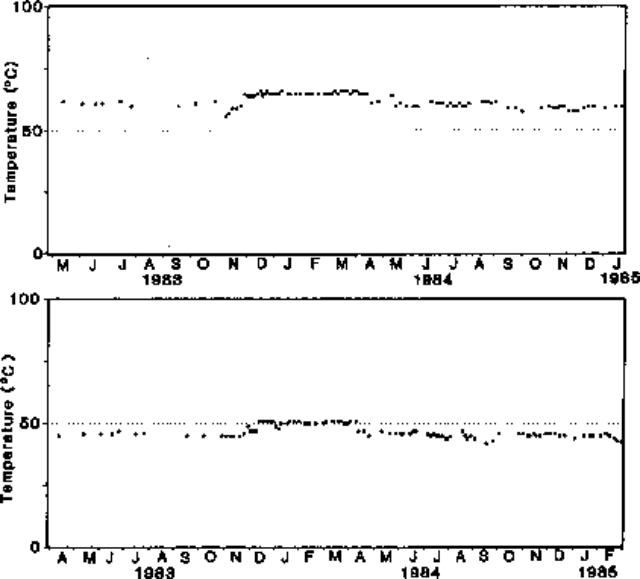 |
Figure 13. Temperature measurements at the same wells as in figure 12: top, 26 April 1983-23 January 1985 (Tortorelli); bottom, 30 March 1983-2 March 1985 (Damiani). Courtesy of OV. |
"A maximum uplift of 180 cm has occurred since June 1982, and 320 cm since 1969 (figure 14). The moderate seismic activity during the present crisis has caused extensive damage to old buildings. We consider this period of unrest as the major geological event at Campi Flegrei in the last 180 years (since the first measurements of sea level in the area). The order of magnitude of the ground uplift during the last 16 years is comparable to that which occurred before the eruption of Monte Nuovo in 1538, and we consider this phase as a possible precursor (on a time scale of years) to new volcanic activity.
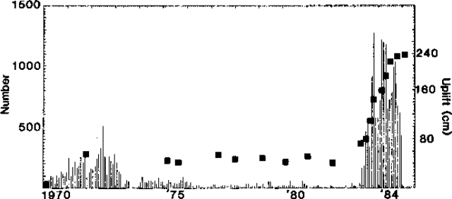 |
Figure 14. Uplift and seismicity at Campi Flegrei, 1970-84. Squares show relative height of benchmark no. 15 of the levelling network (see figure 2), vertical lines show monthly number of seismic events. Courtesy of OV. |
"If the present crisis follows the same pattern as that of 1969-72, we must expect a period of slight subsidence, followed by a period of slight oscillations of the ground level, until a new crisis eventually occurs. The reversal of the secular pattern of subsidence of the area (the most significant in 450 years) that occurred in 1969, along with the relatively long period of quiescence of Vesuvius (since 1944; 6 times longer than any repose period since 1694) may all be related to a change in the stress field controlling volcanic activity in the Naples area."
Further References. Barberi, F., Hill, D., Innocenti, F., Luongo, G., and Treiul, M., eds., 1984, The 1982-1984 bradyseismic crisis at Phlegraean Fields (Italy): B.V., v. 47, no. 2, p. 173-370 (21 papers).
Rosi, M, and Sbrana, A., eds., 1987, Phlegrean Fields: Quaderni de "La Ricerca Scientifica" 114, v. 9, 176 p.
Lirer, L., Luongo, G., and Scandone, R., 1987, On the volcanological evolution of Campi Flegrei, Italy: EOS, v. 68, no. 16, p. 226-234.
Geological Summary. Campi Flegrei is a 13-km-wide caldera that encompasses part of Naples and extends to the south beneath the Gulf of Pozzuoli. Episodes of significant uplift and subsidence within the dominantly trachytic caldera have occurred since Roman times. The earliest known eruptive products are dated 47,000 years BP. The caldera formed following two large explosive eruptions, the massive Campanian ignimbrite about 36,000 BP, and the over 40 km3 Neapolitan Yellow Tuff (NYT) about 15,000 BP. Following eruption of the NYT a large number of eruptions originated from widely scattered subaerial and submarine vents. Most activity occurred during three intervals: 15,000-9,500, 8,600-8,200, and 4,800-3,800 BP. The latest eruption were in 1158 CE at Solfatara and activity in 1538 CE that formed the Monte Nuovo cinder cone.
Information Contacts: G. Luongo, R. Scandone, and R. Pece, OV; F. Barberi, Univ. di Pisa.