Report on Soputan (Indonesia) — February 1985

Scientific Event Alert Network Bulletin, vol. 10, no. 2 (February 1985)
Managing Editor: Lindsay McClelland.
Soputan (Indonesia) Plumes from the May and August 1984 eruptions seen on satellite images
Please cite this report as:
Global Volcanism Program, 1985. Report on Soputan (Indonesia) (McClelland, L., ed.). Scientific Event Alert Network Bulletin, 10:2. Smithsonian Institution. https://doi.org/10.5479/si.GVP.SEAN198502-266030
Soputan
Indonesia
1.112°N, 124.737°E; summit elev. 1785 m
All times are local (unless otherwise noted)
Yosihiro Sawada observed a series of plumes from the May and August 1984 eruptions of Soputan (table 2) on images from the GMS satellite. In 9:5, Adjat Sudradjat reported that Soputan erupted from 24 May at 2243 until 26 May at 0300, depositing tephra west of the volcano. A GMS infrared image 25 May at 2300 shows a nearly circular plume rising from the volcano. By the time of the next image, at 0500 the next day, a large eruption cloud was evident, but feeding from the volcano had ended 2 hours before. Six hours later, the plume was clearly detached from the volcano. A 5-hour explosive eruption of Soputan started 31 August at 0709 and lasted until about noon. A circular eruption column was evident less than an hour after the start of the activity (figure 1, left) and a large plume was visible 6 hours later, about 2 hours after the eruption ended (figure 1, right).
Table 2. Dimensions of plumes from Soputan determined from GMS images by Yosihiro Sawada.
| Date | Hour | Density | Width (km) | Length (km) | Movement direction | Minimum plume temperature |
| 25 May 1984 | 2300 | dense | 60 | 60 | circular | -79°C |
| 26 May 1984 | 0500 | dense | 190 | 240 | NW | -82°C |
| 26 May 1984 | 1100 | dense | 160 | 330 | NW | -70°C |
| 26 May 1984 | 1700 | diffuse | 460 | 440 | W | -- |
| 31 Aug 1984 | 0800 | dense | 30 | 40 | circular | -74°C |
| 31 Aug 1984 | 1400 | dense | 350 | 420 | W | -75°C |
| 31 Aug 1984 | 2000 | diffuse | 430 | 660 | W | -- |
| 01 Sep 1984 | 0200 | diffuse | 430 | 360 | W | -- |
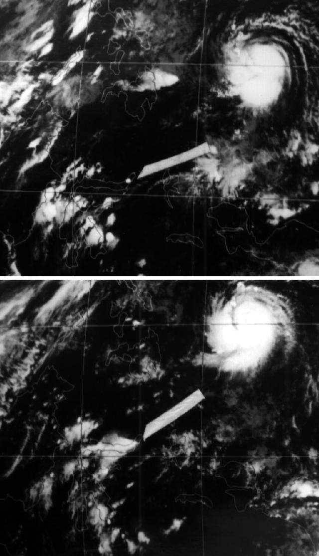 |
Figure 1. GMS infrared satellite images with arrows pointing to eruption clouds from Soputan 31 August 1984 at 0800 (top), and 1400 (bottom). Courtesy of Yosihiro Sawada. |
Geological Summary. The Soputan stratovolcano on the southern rim of the Quaternary Tondano caldera on the northern arm of Sulawesi Island is one of Sulawesi's most active volcanoes. The youthful, largely unvegetated volcano is the only active cone in the Sempu-Soputan volcanic complex, which includes the Soputan caldera, Rindengan, and Manimporok (3.5 km ESE). Kawah Masem maar was formed in the W part of the caldera and contains a crater lake; sulfur has been extracted from fumarolic areas in the maar since 1938. Recent eruptions have originated at both the summit crater and Aeseput, a prominent NE-flank vent that formed in 1906 and was the source of intermittent major lava flows until 1924.
Information Contacts: Y. Sawada, MRI, Tsukuba.