Report on Mayon (Philippines) — February 1985

Scientific Event Alert Network Bulletin, vol. 10, no. 2 (February 1985)
Managing Editor: Lindsay McClelland.
Mayon (Philippines) Eruption clouds from 23 September seen on satellite images
Please cite this report as:
Global Volcanism Program, 1985. Report on Mayon (Philippines) (McClelland, L., ed.). Scientific Event Alert Network Bulletin, 10:2. Smithsonian Institution. https://doi.org/10.5479/si.GVP.SEAN198502-273030
Mayon
Philippines
13.257°N, 123.685°E; summit elev. 2462 m
All times are local (unless otherwise noted)
Yosihiro Sawada observed a series of plumes from the September 1984 eruption of Mayon (table 1) on images from the GMS satellite. Problems with the scanning system of the GMS limited images to every 6 hours during the spring and summer, and at times prevented data returns from its southern zone of coverage.
Table 1. Series of plumes from the September 1984 eruption of Mayon observed on images from the GMS satellite. Plume lengths and widths were measured from images rather than digital data. Courtesy of Yosihiro Sawada.
| Date | Hour | Density | Width (km) | Length (km) | Movement Direction |
| 09 Sep 1984 | ?14 | diffuse | 30 | 60 | W |
| 11 Sep 1984 | ?14 | diffuse | 50 | 70 | WSW |
| 12 Sep 1984 | ?14 | diffuse | 20 | 60 | W |
| 13 Sep 1984 | ?00 | diffuse | 70 | 110 | SW |
| 13 Sep 1984 | 08 | diffuse | 20 | 70 | SW |
| 13 Sep 1984 | 14 | diffuse | 20 | 90 | SW |
| 15 Sep 1984 | 08 | diffuse | 20 | 70 | NW |
| 15 Sep 1984 | 14 | diffuse | 30 | 40 | NW |
| 16 Sep 1984 | 08 | diffuse | 30 | 70 | W |
| 16 Sep 1984 | 14 | diffuse | 30 | 40 | W |
| 16 Sep 1984 | 20 | diffuse | 30 | 80 | W |
| 17 Sep 1984 | 02 | diffuse | 30 | 40 | W |
| 18 Sep 1984 | 02 | diffuse | 30 | 40 | SW |
| 18 Sep 1984 | 08 | diffuse | 40 | 50 | W |
| 18 Sep 1984 | 14 | diffuse | 30 | 60 | W |
| 18 Sep 1984 | 20 | diffuse | 30 | 60 | W |
| 19 Sep 1984 | 02 | diffuse | 30 | 60 | W |
| 20 Sep 1984 | 02 | diffuse | 40 | 70 | NW |
| 22 Sep 1984 | 02 | diffuse | 40 | 60 | W |
| 23 Sep 1984 | 08 | dense | 40 | 120 | W |
| 23 Sep 1984 | 14 | dense | 80 | 260 | W |
| 23 Sep 1984 | 20 | dense | 40 | 140 | W |
| 24 Sep 1984 | 02 | dense | 40 | 220 | W |
| 24 Sep 1984 | 08 | dense | 80 | 190 | W |
| 24 Sep 1984 | 14 | dense | 70 | 100 | SW |
| 24 Sep 1984 | 20 | diffuse | 70 | 80 | SW |
| 25 Sep 1984 | 02 | diffuse | 40 | 40 | SW |
| 25 Sep 1984 | 08 | diffuse | 40 | 80 | W |
| 25 Sep 1984 | 14 | diffuse | 40 | 60 | NW |
Eruption clouds from Mayon's intense activity 23-24 September appeared much larger and denser on satellite imagery than those from the early- to mid-September activity. A moderate plume on 23 September at 0800 had grown much larger 6 hours later (figure 3, left and right) and plumes remained large and dense through 1400 the next day. Declining activity remained visible until 26 September at 1400.
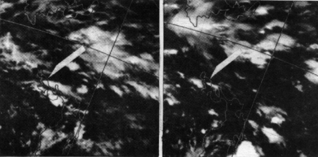 |
Figure 3. GMS infrared satellite images with arrows pointing to eruption clouds from Mayon, 23 September 1984 at 0800 (left) and 1400 (right). Land areas are outlined with fine white lines. Courtesy of Yosihiro Sawada. |
Further Reference. Sawada, Y., 1987, Study on analysis of volcanic eruption cloud image data obtained by the Geostationary meteorological Satellite (GMS): Technical Reports of the Meteorological Research institute (Japan), no. 22, 335 p.
Geological Summary. Symmetrical Mayon, which rises above the Albay Gulf NW of Legazpi City, is the most active volcano of the Philippines. The steep upper slopes are capped by a small summit crater. Recorded eruptions since 1616 CE range from Strombolian to basaltic Plinian, with cyclical activity beginning with basaltic eruptions, followed by longer periods of andesitic lava flows. Eruptions occur predominately from the central conduit and have also produced lava flows that travel far down the flanks. Pyroclastic density currents and mudflows have commonly swept down many of the approximately 40 ravines that radiate from the summit and have often damaged populated lowland areas. A violent eruption in 1814 killed more than 1,200 people and devastated several towns.
Information Contacts: Y. Sawada, Meteorological Research Institute, Tsukuba, Japan.