Report on Long Valley (United States) — October 1985

Scientific Event Alert Network Bulletin, vol. 10, no. 10 (October 1985)
Managing Editor: Lindsay McClelland.
Long Valley (United States) Continued deformation and low-level seismicity
Please cite this report as:
Global Volcanism Program, 1985. Report on Long Valley (United States) (McClelland, L., ed.). Scientific Event Alert Network Bulletin, 10:10. Smithsonian Institution. https://doi.org/10.5479/si.GVP.SEAN198510-323822
Long Valley
United States
37.7°N, 118.87°W; summit elev. 3390 m
All times are local (unless otherwise noted)
The quoted material is from the USGS.
"Since the spring of 1983, seismicity has persisted at relatively low levels and regional extensional deformation and uplift centered over the resurgent dome have continued.
"Seismicity and geodetic measurements through August 1985 indicated that broad-scale deformation across the entire caldera was continuing. However, decreases have occurred in both seismicity within the caldera and the rate of deformation within the S moat, the region of the caldera between the resurgent dome and the S rim (figure1).
"No detectable earthquakes occurred within the caldera 1-23 July, and only 4 small ones (M <2.2) were recorded during the last 8 days of June. On 24 July, however, the low-level seismicity characteristic of the previous several months (an average of 0.7 events with magnitude greater than or equal to 1 per day) resumed and continued through August. The largest July-August earthquake in the caldera was a M 2.1 event on 12 August. Preliminary examination of more recent data suggests that this pattern of low-level seismicity continued through September and October.
"Recently completed annual measurements of the regional trilateration network and several of the major level lines indicated that regional extensional deformation and uplift centered over the resurgent dome continued at rates little changed from those measured from mid-1980 to mid-1984. Summer 1985 results for the level line along Highway 395, for example, showed that cumulative uplift for bench marks near Casa Diablo (at the S side of the resurgent dome) was 47 cm with respect to elevations measured in 1975 (figure 2).
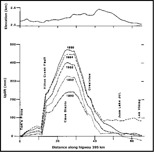 |
Figure 2. Elevation differences in Long Valley Caldera for 1980-85, relative to the 1975 survey. Traverse is along Highway 395 between Tom's Place and Lee Vining. Courtesy of David Hill and James Savage. |
"Data from the frequently measured 2-color geodimeter network showed that local deformation within the S moat, including the epicentral region of the major January 1983 earthquake swarm, continued to slow and had virtually stopped along certain lines. July-August data from the telemetered tiltmeters are consistent with minimal local deformation within the caldera. Data from a continuously recording dilational strainmeter in a borehole about 3 km outside the caldera (at Devil's Postpile) showed that the strain rate apparently decreased somewhat abruptly on about 20 June, and remained flat until a small change about 28 August. Measurements of magnetic field variations at two locations in the SE and NW parts of the caldera (Hot Creek and Smokey Bear Flat) showed no changes through August.
"The geodetic evidence that broad-scale deformation across the entire caldera is continuing at a more or less uniform rate points to continuing inflation of the deeper section of the magma chamber (depths of 10-12 km). In contrast, the marked decrease in both the seismicity rate within the caldera and the rate of local deformation across the S moat indicate that stress differences in the upper crust associated with the January 1983 earthquake swarm (and possible related intrusive event) have substantially relaxed. However, as long as we see evidence for continuing inflation of the deeper magma chamber, we must regard the recurrence of another episode of unrest somewhere within the caldera as a distinct possibility."
In cooperation with the USGS, the California Division of Mines and Geology installed a system for monitoring seismicity within the caldera, with particular emphasis on low-frequency events. Stephen McNutt reported that no low-frequency events were recorded in the caldera between July 1984, when the system became operational, and October 1985.
Further References. Hill, D.P., Bailey, R.A., and Ryall, A.S., 1984, Proceedings of Workshop XIX: Active Tectonic and Magmatic Processes Beneath Long Valley Caldera, Eastern California; USGS Open File Report 84-939, 942 p. (32 papers).
Savage, J.C., Cockerham, R.S., and Estrem, J.E., 1987, Deformation Near the Long Valley Caldera, Eastern California, 1982-1986; JGR, v. 92, no. B3, p. 2721-2746.
Special Section — Long Valley Caldera, California; JGR, 1985, v. 90, no. B13, p. 11111-11252 (14 papers).
Geological Summary. The large 17 x 32 km Long Valley caldera east of the central Sierra Nevada Range formed as a result of the voluminous Bishop Tuff eruption about 760,000 years ago. Resurgent doming in the central part of the caldera occurred shortly afterwards, followed by rhyolitic eruptions from the caldera moat and the eruption of rhyodacite from outer ring fracture vents, ending about 50,000 years ago. During early resurgent doming the caldera was filled with a large lake that left strandlines on the caldera walls and the resurgent dome island; the lake eventually drained through the Owens River Gorge. The caldera remains thermally active, with many hot springs and fumaroles, and has had significant deformation, seismicity, and other unrest in recent years. The late-Pleistocene to Holocene Inyo Craters cut the NW topographic rim of the caldera, and along with Mammoth Mountain on the SW topographic rim, are west of the structural caldera and are chemically and tectonically distinct from the Long Valley magmatic system.
Information Contacts: D. Hill, J. Savage, USGS, Menlo Park, CA; S. McNutt, California Div. of Mines & Geology.