Report on Kasuga 1 (United States) — November 1985
Scientific Event Alert Network Bulletin, vol. 10, no. 11 (November 1985)
Managing Editor: Lindsay McClelland.
Kasuga 1 (United States) No water discoloration observed, December 1983-December 1985
Please cite this report as:
Global Volcanism Program, 1985. Report on Kasuga 1 (United States) (McClelland, L., ed.). Scientific Event Alert Network Bulletin, 10:11. Smithsonian Institution. https://doi.org/10.5479/si.GVP.SEAN198511-284134
Kasuga 1
United States
21.765°N, 143.71°E; summit elev. -598 m
All times are local (unless otherwise noted)
JMSA has continued frequent aerial monitoring of several known submarine volcanoes. Volcanic activity has often been observed at Fukutoku-okanoba during overflights since late 1983, but no water discoloration has been seen at Kasuga, Nikko, or Fukujin.
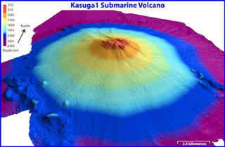
Geological Summary. Kasuga 1, the northernmost of three seamounts in the the Kasuga seamount chain SE of Fukujin, rises from a depth of 3,000 m to within about 600 m of the ocean surface. A series of flank vents are located low on the southern side of the edifice. The summit does not have a caldera or display hydrothermal activity, and is largely covered by volcaniclastics. Altered basaltic and andesitic rocks dredged from the summit suggest that it is the oldest of the three seamounts, although delicately preserved lava flow lobes and toes from a flank eruption suggest a very youthful age. It is listed as an active volcano by the Japan Meteorological Agency, and floating pumice attributed to a submarine eruption was seen south of it in the summer of 1959. Water discoloration from a possible submarine eruption was reported near the seamount in November 1975.
Information Contacts: JMA, Tokyo.