Report on Nevado del Ruiz (Colombia) — November 1985

Scientific Event Alert Network Bulletin, vol. 10, no. 11 (November 1985)
Managing Editor: Lindsay McClelland.
Nevado del Ruiz (Colombia) Seismic swarms, latest with inflation; more on 13 November activity and products
Please cite this report as:
Global Volcanism Program, 1985. Report on Nevado del Ruiz (Colombia) (McClelland, L., ed.). Scientific Event Alert Network Bulletin, 10:11. Smithsonian Institution. https://doi.org/10.5479/si.GVP.SEAN198511-351020
Nevado del Ruiz
Colombia
4.892°N, 75.324°W; summit elev. 5279 m
All times are local (unless otherwise noted)
Since the 13 November eruption, activity at Ruiz has been limited to emission of a vapor plume and a few seismic swarms, one accompanied by measureable inflation. Work by numerous geologists has yielded new information on the 13 November eruption, its products, and pre-eruption activity.
Pre-13 November activity. The most vigorous seismic energy release at Ruiz occurred in the days preceding the 11 September ash emission. The rate of energy release increased prior to the 13 November eruption, but more gradually than before the 11 September activity. Hypocenters were concentrated N and NE of the summit with best-located events concentrated at depths 0-1 km below sea level (figure 3).
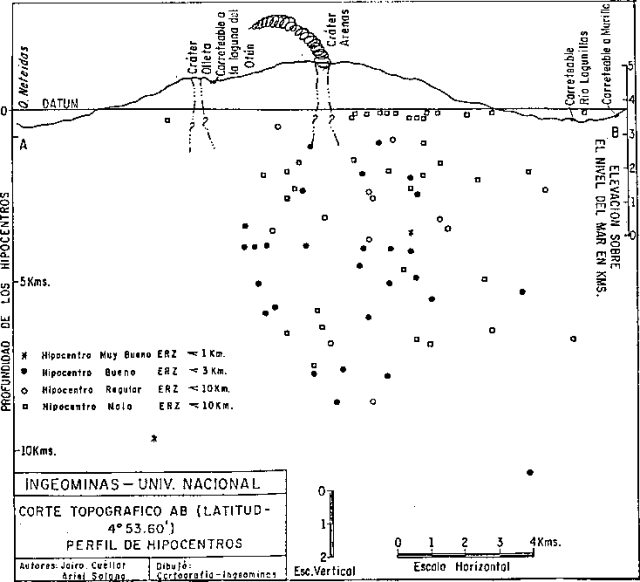 |
Figure 3. Pre-13 November 1985 hypocenters projected onto a vertical E-W plane passing through the summit of Ruiz. Depths are below a datum at 3.8 km altitude. No vertical exaggeration. Reprinted from Estudio de los Riesgos Potentiales del Volcán Nevado del Ruiz; Informe de las Actividades Desarolladas (Periodo Octubre 8 - Noviembre 10, 1985); INGEOMINAS, Bogotá, Colombia. |
The quoted material below is from a report from Rodolfo Van der Laat, Eduardo Parra, and Heyley Vergara.
"After 11 September, when there was a significant ash emission, activity at Ruiz had decreased notably through 10 November. The activity caused concern in Manizales (30 km NW of Arenas Crater), but the presentation by INGEOMINAS of a preliminary volcanic risk map (figure 4) calmed the population.
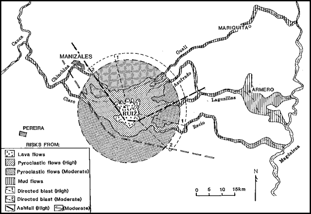 |
Figure 4. Volcanic risk map presented by geologists from INGEOMINAS and the Univ. de Caldas to officials and the press before the 13 November 1985 eruption. Some redrafting has been done to facilitate reproduction in the Bulletin, but boundaries of hazard zones are unchanged. |
"Seismic activity reached a maximum of 60 events per day 19-21 October, declining by 3 November to 3-5 daily locatable events. An increase in temperature of the thermal vent 'La Hedionda' (on the NE flank) may have been related to the increase in seismic activity.
"The height of the plume during this period decreased from about 3 km at the end of September and the beginning of October to about 800 m, with an occasional nucleus of ash 200-300 m high. There were two main fumarolic vents: one yellowish (sulfur), the smaller one gray/coffee-colored (ash derived from mud).
"A tilt network was established, detecting a general deflation 26 October-3 November, with small pulses of inflation of the order of 5-10 µrad per day. At the beginning of November, the first measurement was made of a geodesic net to monitor horizontal deformation by the Instituto Geográfico Agustín Codazzi."
13 November eruption and products. Details of the 13 November eruption sequence remain uncertain and field investigations were still in progress at press time. An initial explosion at 1530 deposited a very thin, fine-grained layer of ash around the summit and NNE of the volcano. The main explosion started at 2108 or 2109 and continued for 20-30 minutes. Five kilometers from the crater, tephra from the main explosion was 7 cm thick and included 30-cm pumice fragments, but the deposit thinned rapidly and was only 1-2 mm thick at Armero with similar amounts at Mariquita and Honda (75 km NE). Preliminary estimates by Haraldur Sigurdsson and Steven Carey place the volume of tephra at roughly 39 x 106 m3. Cloudy weather and lack of nearby wind data on 13 November impeded determination of the height of the Ruiz eruption column. Based on the position of tephra diameter isopleths, Sigurdsson and Carey inferred that the top of the eruption cloud reached [31] km altitude, but emphasized that most of the tephra probably remained in the upper troposphere [Naranjo and others, 1986].
Mudflows that moved E down the valleys of the Lagunillas and Azufrado rivers and inundated Armero were overlain by airfall tephra within 5-10 km of the volcano. However, the mudflow that moved W down the Río Claro valley to Chinchiná contained fresh pumice, and the fluid mudflow that traveled down the Gualí river washed tephra off vegetation, suggesting that both were generated after tephra ejection. The Armero mudflows emerged from both the Lagunillas and Azufrado valleys, which join upstream from the city. The first wave of mud, probably from the Lagunillas, was apparently colder, lighter colored, more water-rich, and formed a more extensive deposit than the second wave, probably from the Azufrado, which was hotter, coarser, and darker-colored. Donald Lowe estimated that outflow from the mouth of the Río Lagunillas reached about 47,500 m3/s. Preliminary calculations by Sigurdsson and Carey yield a volume of about 30-60 x 106 m3 for the deposits of the Armero, and Gualí and Chinchiná valley mudflows, plus about 30-90 x 106 m3 of water, roughly 6-18% of the pre-eruption volume of the summit ice cap. The Lagunillas mudflow probably included water from a lake that had been trapped behind a debris dam in that valley's headwaters for at least several months. Other estimates suggested that about 5% of the summit ice was removed during the 13 November eruption.
Preliminary chemical analyses of a few samples of the 13 November pumice suggest that it is a hypersthene andesite, very similar to an earlier pumice that was probably from Ruiz's last large eruption, in 1595. Little systematic variation was found in different-colored samples that had suggested mixed magma in hand specimen (table 1).
Table 1. Preliminary analyses of bulk compositions of Ruiz pumice (1-4) and glass septa (5-6). Numbers 1, 2, 5, and 6 are from electron microprobe analyses by William Melson and Deborah Reid Jerez; 3 and 4 are X-ray fluorescence analyses by Joseph Taggart.
| Sample | 1 | 2 | 3 | 4 | 5 | 6 |
| SiO2 | 59.31 | 58.69 | 59.50 | 61.50 | 65.36 | 63.97 |
| Al2O3 | 16.83 | 16.81 | 15.70 | 15.20 | 16.01 | 16.33 |
| FeO* | 5.87 | 5.72 | 5.94 | 5.44 | 3.98 | 4.14 |
| MgO | 5.40 | 5.13 | 4.94 | 3.98 | 1.51 | 1.54 |
| CaO | 6.30 | 6.04 | 6.11 | 5.43 | 3.81 | 4.24 |
| K2O | 1.87 | 1.85 | 3.67 | 3.66 | 3.47 | 3.15 |
| Na2O | 3.80 | 3.79 | 2.07 | 2.45 | 4.12 | 4.22 |
| TiO2 | 0.82 | 0.81 | 0.67 | 0.65 | 0.77 | 0.77 |
| P2O5 | 0.30 | 0.28 | 0.19 | 0.19 | 0.30 | 0.29 |
| MnO | -- | -- | 0.09 | 0.09 | -- | -- |
| Total | 100.50 | 99.12 | 98.90 | 98.60 | 99.33 | 98.65 |
Notes: |
||||||
| Samples 1 and 5: 13 November 1985 pumice collected by Stanley Williams. USNM116158. | ||||||
| Samples 2 and 6: Probable 1595 pumice collected by Stanley Williams. USNM116159. | ||||||
Post-13 November activity. No significant eruptive activity occurred in the succeeding weeks. The vapor column varied in height from 200-300 m to 1-1.4 km. Rates of SO2 emission measured by COSPEC were 200 t/d on 18 November, 50 t/d on the 19th, and several thousand tons per day on 22 November. Possible new fissures have been observed near the summit along with possible development of a depression SW of the summit. However, the fissures may have been pre-existing features exposed by clearer weather and seasonal snowmelt. Slight advances of some of the summit glaciers have been noted, but no large-scale ice movements were apparent and there was no evidence of significant melting from below.
Six telemetering seismometers have been installed, ringing the summit at elevations of 4,000-4,500 m, supplementing the four-station seismic net that was in place before 13 November. Telemetering tiltmeters were emplaced at 4,200 m elevation on the NW flank, 4,600 m elevation on the NNW flank, and on the NE flank, and 8-10 EDM lines have been established, in addition to the dry-tilt network installed on the N flank in October.
Seismic energy release was at relatively low levels shortly after the 13 November eruption, but the slope of the energy release curve steepened in the succeeding weeks. Earthquake swarms that were small but of increasing energy occurred 19-20 and 27 November, and 6-7 December. Maximum magnitudes were 2.5-3 in the November swarms; the 6-7 December activity included two magnitude 3-3.5 shocks. Locations were available for only a few events, which were centered along a generally N-S trend, usually somewhat N of the crater. The swarms were not accompanied by measurable tilt episodes or obvious changes to the plume. The rate of seismic energy release doubled during the first day of a stronger swarm 12-13 December and Civil Defense personnel were put on alert. The same day, the NW flank tiltmeter recorded a 5 µrad tilt event, the first change recorded in the weeks since it was installed, and a NW flank EDM line shortened 14 cm between measurements 11 and 13 December. However, seismicity declined 13 December, and the seismic energy release curve was nearly flat 14-17 December.
Geological Summary. Nevado del Ruiz is a broad, glacier-covered volcano in central Colombia that covers more than 200 km2. Three major edifices, composed of andesitic and dacitic lavas and andesitic pyroclastics, have been constructed since the beginning of the Pleistocene. The modern cone consists of a broad cluster of lava domes built within the caldera of an older edifice. The 1-km-wide, 240-m-deep Arenas crater occupies the summit. The prominent La Olleta pyroclastic cone located on the SW flank may also have been active in historical time. Steep headwalls of massive landslides cut the flanks. Melting of its summit icecap during historical eruptions, which date back to the 16th century, has resulted in devastating lahars, including one in 1985 that was South America's deadliest eruption.
Information Contacts: P. Medina, Comité de Estudios Vulcanológicos, Manizales; A. López R., INGEOMINAS, Bogotá; R. Van der Laat, Univ. Nacional, Heredia; E. Parra, INGEOMINAS, Medellín; H. Vergara, INGEOMINAS, Tolima; H. Sigurdsson and S. Carey, Univ. of Rhode Island; S. Williams and D. Lowe, Louisiana State Univ.; A. Londoño C., Univ. Nacional, Manizales; Néstor Garcia P., Industria Licorera de Caldas, Manizales; R. Stoiber and B. Gemmell, Dartmouth College; D. Harlow, USGS, Menlo Park, CA; C. Hearn, D. Klick, D. Herd, and R. Tilling, USGS, Reston, VA; J. Taggart, Jr., USGS, Denver, CO; W. Melson and D. Jerez, SI; P. Clemente-Colón, NOAA/NESDIS.