Report on Kavachi (Solomon Islands) — December 1985
Scientific Event Alert Network Bulletin, vol. 10, no. 12 (December 1985)
Managing Editor: Lindsay McClelland.
Kavachi (Solomon Islands) Submarine explosions
Please cite this report as:
Global Volcanism Program, 1985. Report on Kavachi (Solomon Islands) (McClelland, L., ed.). Scientific Event Alert Network Bulletin, 10:12. Smithsonian Institution. https://doi.org/10.5479/si.GVP.SEAN198512-255060
Kavachi
Solomon Islands
8.991°S, 157.979°E; summit elev. -20 m
All times are local (unless otherwise noted)
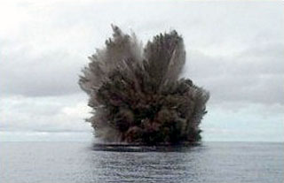
On the morning of 30 December, Solair Captain Brian Smith observed dirty water over Kavachi while flying from Honiara to Munda. When he returned to Honiara that afternoon, Kavachi was ejecting rock debris, mud, steam, and water to a height of 30 m. The eruption was observed by the captain and crew of the MV Iu Mi Nao the same afternoon. On 31 December, the eruption was intensifying, with one explosion per minute ejecting material to 200-300 m height. By 1 January, both eruptive intensity and height of the ejecta column had decreased. On 7 January, Deni Tuni observed explosions while en route to Honiara on the MR Compass Rose II. Two explosions ejected black plumes that probably contained ash to about 20 m height. A third explosion, which appeared to consist mainly of steam and perhaps other gases, spread along the horizon, forming a pyramid-shaped cloud before disappearing. As of mid-January, no island had formed.
Geological Summary. Named for a sea-god of the Gatokae and Vangunu peoples, Kavachi is located in the Solomon Islands south of Vangunu Island. Sometimes referred to as Rejo te Kvachi ("Kavachi's Oven"), this shallow submarine basaltic-to-andesitic volcano has produced ephemeral islands up to 1 km long many times since its first recorded eruption during 1939. Residents of the nearby islands of Vanguna and Nggatokae (Gatokae) reported "fire on the water" prior to 1939, a possible reference to earlier eruptions. The roughly conical edifice rises from water depths of 1.1-1.2 km on the north and greater depths to the SE. Frequent shallow submarine and occasional subaerial eruptions produce phreatomagmatic explosions that eject steam, ash, and incandescent bombs. On a number of occasions lava flows were observed on the ephemeral islands.
Information Contacts: D. Tuni, Ministry of Natural Resources, Honiara.