Report on Tacana (Mexico-Guatemala) — February 1986
Scientific Event Alert Network Bulletin, vol. 11, no. 2 (February 1986)
Managing Editor: Lindsay McClelland.
Tacana (Mexico-Guatemala) Local seismicity continues
Please cite this report as:
Global Volcanism Program, 1986. Report on Tacana (Mexico-Guatemala) (McClelland, L., ed.). Scientific Event Alert Network Bulletin, 11:2. Smithsonian Institution. https://doi.org/10.5479/si.GVP.SEAN198602-341130
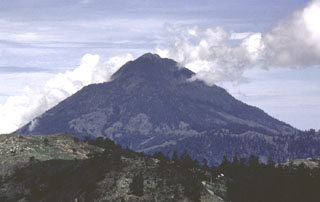
Tacana
Mexico-Guatemala
15.132°N, 92.109°W; summit elev. 4064 m
All times are local (unless otherwise noted)
The series of shallow earthquakes near Tacaná was continuing in early March. Many of the shocks were felt near the volcano. There were no apparent changes to fumaroles on and around the volcano. To supplement permanent seismometers 30 km SW and 80 km N of the volcano (near Tapachula and Comitán), Mexican geophysicists installed portable instruments about 27 km NW of the volcano (at Motozintla), W of the volcano (at El Aguila) and about 6 km S of the summit (at Unión Juárez).
The majority of felt events were subduction zone earthquakes centered under the coast of northernmost Guatemala. Other events originated in a fault system NE of the volcano, in Guatemala. A third type consisted of events under the volcano, characterized by sharp P arrivals and very long S-wave trains, that were strong enough to be felt and heard within 10 km of the volcano. Apparent volcanic tremor episodes with amplitudes just above noise levels were recorded 2-3 times a day. The rate of seismic energy release increased substantially 18-25 February, declined significantly after 25 February, then started to increase again on 3 March. On 3 March between 0400 and 1200, a bubble tiltmeter 6 km S of the summit (at 1,800 m elevation) indicated a sharp deformation event corresponding to about 100 microradians of deflation on an azimuth of 073°. However, relevelling of a line extending 1 km N and 4 km S of the tiltmeter (including one station only a few tens of meters away) revealed no changes. On 10 March about 0200, seismic instruments detected several events that looked like explosion shocks, followed by about 2 minutes of very minor tremor. The events were felt and heard by many residents of towns around the volcano, but no eruption occurred. The government of the state of Chiapas, México has prepared a contingency plan to respond to several levels of volcanic risk, including evacuation of people within 15 km of the volcano if necessary.
Geological Summary. Tacaná is a 4064-m-high composite stratovolcano that straddles the México/Guatemala border at the NW end of the Central American volcanic belt. The volcano rises 1800 m above deeply dissected plutonic and metamorphic terrain. Three large calderas breached to the south, and the elongated summit region is dominated by a series of lava domes intruded along a NE-SW trend. Volcanism has migrated to the SW, and a small adventive lava dome is located in the crater of the youngest volcano, San Antonio, on the upper SW flank. Viscous lava flow complexes are found on the north and south flanks, and lobate lahar deposits fill many valleys. Radial drainages on the Guatemalan side are deflected by surrounding mountains into the Pacific coastal plain on the SW side of the volcano. Historical activity has been restricted to mild phreatic eruptions, but more powerful explosive activity, including the production of pyroclastic flows, has occurred as recently as about 1950 years ago.
Information Contacts: S. de la Cruz-Reyna, UNAM, México D.F.