Report on Tacana (Mexico-Guatemala) — June 1986
Scientific Event Alert Network Bulletin, vol. 11, no. 6 (June 1986)
Managing Editor: Lindsay McClelland.
Tacana (Mexico-Guatemala) Seismicity declines after May explosion; steaming
Please cite this report as:
Global Volcanism Program, 1986. Report on Tacana (Mexico-Guatemala) (McClelland, L., ed.). Scientific Event Alert Network Bulletin, 11:6. Smithsonian Institution. https://doi.org/10.5479/si.GVP.SEAN198606-341130
Tacana
Mexico-Guatemala
15.132°N, 92.109°W; summit elev. 4064 m
All times are local (unless otherwise noted)
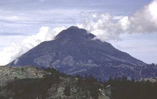
Seismicity declined after the 8 May phreatic explosion and in early June about 1-2 events were recorded/day. In late June, the active vent continually emitted steam, typically to about 500 m height, with a noise like a jet engine. The vent, about 20 m in diameter, was located at the foot of a 30-m cliff along an apparent radial fault extending from the summit. Poor access prevented direct gas sampling, but a weak odor of H2S was noted in the vicinity of the cloud. An apron of muddy, clay-rich debris surrounded the vent. Samples of February ejecta examined under a microscope were strongly altered. May and June material was less altered, but no glass was evident in any of the samples. Residents of the area who experienced the last activity in 1949-50 reported that the 1986 seismicity seemed stronger and the vent developed much more suddenly. The 1949-50 activity, on the upper SW flank, occurred from numerous small fumaroles rather than from a single vent and was apparently shorter-lived (Müllerried, 1951).
Vigorous monitoring efforts by scientists in México and Guatemala continue. Contingency plans have been prepared by the state government of Chiapas México, and a hazards assessment and map were produced under the auspices of Guatemala's INSIVUMEH (Rose and Mercado, 1986).
References. Müllerried, F.K.G., 1951, La reciente actividad del Volcán de Tacaná, Estado de Chiapas, a fines de 1949 y principios de 1950: Depto. de Prensa y Turismo, Tuxtla-Gutierrez, México, 28 p.
De la Cruz Martínez, V., and Hernández Zuñiga, R., 1986, Geología del Volcán Tacaná: Geotermia, Revista Mexicana de Geoenergía, v. 2, no. 1, p. 5-21.
Rose, W.I., and Mercado. R., 1986, Report on UNDRO/OFDA mission to Tacaná Volcano Guatemala/México: INSIVUMEH, Guatemala, 30 p. + 3 maps (in English or Spanish).
Further Reference. de la Cruz-Reyna, S., Armienta, M.A., Zamora, V., and Juarez, F., 1989, Chemical changes at spring waters at Tacana Volcano, Chiapas, Mexico; a possible precursor of the May 1986 seismic crisis and phreatic explosion: JVGR, v. 38, p. 345-353.
Geological Summary. Tacaná is a 4064-m-high composite stratovolcano that straddles the México/Guatemala border at the NW end of the Central American volcanic belt. The volcano rises 1800 m above deeply dissected plutonic and metamorphic terrain. Three large calderas breached to the south, and the elongated summit region is dominated by a series of lava domes intruded along a NE-SW trend. Volcanism has migrated to the SW, and a small adventive lava dome is located in the crater of the youngest volcano, San Antonio, on the upper SW flank. Viscous lava flow complexes are found on the north and south flanks, and lobate lahar deposits fill many valleys. Radial drainages on the Guatemalan side are deflected by surrounding mountains into the Pacific coastal plain on the SW side of the volcano. Historical activity has been restricted to mild phreatic eruptions, but more powerful explosive activity, including the production of pyroclastic flows, has occurred as recently as about 1950 years ago.
Information Contacts: W.I. Rose, Michigan Tech; E. Sánchez, Edgar Quevec R., and Enrique Molina C., INSIVUMEH; Stephen Malone, Univ of Washington, USA.