Report on Long Valley (United States) — February 1987

Scientific Event Alert Network Bulletin, vol. 12, no. 2 (February 1987)
Managing Editor: Lindsay McClelland.
Long Valley (United States) Tectonic seismicity and slow inflation in 1986
Please cite this report as:
Global Volcanism Program, 1987. Report on Long Valley (United States) (McClelland, L., ed.). Scientific Event Alert Network Bulletin, 12:2. Smithsonian Institution. https://doi.org/10.5479/si.GVP.SEAN198702-323822
Long Valley
United States
37.7°N, 118.87°W; summit elev. 3390 m
All times are local (unless otherwise noted)
The following is from a summary of 1986 activity by David Hill. "Earthquake activity ... persisted at a low level throughout 1986. The average seismicity rate was 0.5 events (M >1)/day with only 1 event reaching M 3.0, on 14 March. That event was centered in the S moat ~ 1 km S of the resurgent dome. Activity in the Sierra Nevada block to the S persisted at a somewhat higher level (figure3). Two M 3.0 events occurred in January and another in mid-March.
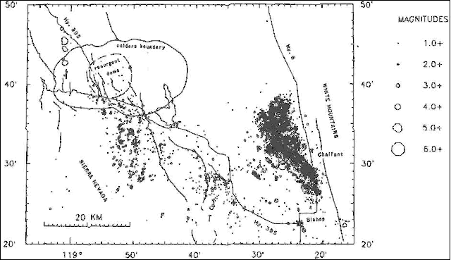 |
Figure 3. Epicenters of Long Valley Area earthquakes M >1.0 for 1986. Courtesy of D. Hill. |
"The seismically active region expanded E (figure 3) to include the area near the W front of the White Mountains (Chalfant Valley), ~20 km E of Long Valley Caldera; this area had very little earthquake activity in previous years. Low-level foreshock activity on 3 July culminated in a M 5.8 foreshock on 20 July. The M [6.2] mainshock occurred on 21 July and was followed by a vigorous aftershock sequence that included three M >5 events and several thousand smaller events, many of which were locally felt. Focal mechanisms for three of the larger events in the sequence showed predominantly right-lateral slip with a small component of normal slip on NNW-striking planes dipping 55-90° W. A series of preliminary reports on this earthquake sequence were published in Bulletin of the Seismological Society of America (v. 77, no. 1, p. 280-313).
"The dominant deformation event during 1986 was associated with the Chalfant Valley mainshock. This earthquake resulted in a 0.5 x 10⁻⁶ co-seismic strain change across the caldera as recorded by the two-color geodimeter network and the borehole dilatometer at Devils Postpile. These observations were consistent with the deformation field expected from roughly 1.5 m of right-oblique slip in a 15-km-long buried fault beneath Chalfant Valley striking N55°W, dipping 55°W, and with the seismic 25 dyne-cm based on teleseismic data. Deformation measurements from 1986 otherwise showed little change from what appeared to be a gradual long-term slowing trend throughout the region. Two-color laser data showed the same slow extension (roughly 1 microstrain/year) across the SW section of the caldera that has occurred for the last several years. Annual measurements of the regional trilateration and levelling networks completed this summer showed only marginally significant changes in line length and elevation. The telemetered data from the borehole tiltmeters and the borehole dilatometer showed no unusual excursions during the year.
"The hydrologic system in the caldera also remained relatively stable throughout 1986, showing normal seasonal changes. The most pronounced short-term variations involved co-seismic changes in the water level in monitored wells and in the flow rates of some hot springs accompanying the Chalfant Valley mainshock."
Further Reference. Savage, J., Cockerham R., Estrem, J., and Moore, L., 1987, Deformation Near the Long Valley Caldera, Eastern California, 1982-1986; Journal of Geophysical Research, v. 92, p. 2721-2746.
Geological Summary. The large 17 x 32 km Long Valley caldera east of the central Sierra Nevada Range formed as a result of the voluminous Bishop Tuff eruption about 760,000 years ago. Resurgent doming in the central part of the caldera occurred shortly afterwards, followed by rhyolitic eruptions from the caldera moat and the eruption of rhyodacite from outer ring fracture vents, ending about 50,000 years ago. During early resurgent doming the caldera was filled with a large lake that left strandlines on the caldera walls and the resurgent dome island; the lake eventually drained through the Owens River Gorge. The caldera remains thermally active, with many hot springs and fumaroles, and has had significant deformation, seismicity, and other unrest in recent years. The late-Pleistocene to Holocene Inyo Craters cut the NW topographic rim of the caldera, and along with Mammoth Mountain on the SW topographic rim, are west of the structural caldera and are chemically and tectonically distinct from the Long Valley magmatic system.
Information Contacts: D. Hill, USGS Menlo Park.