Report on Lascar (Chile) — April 1987
Scientific Event Alert Network Bulletin, vol. 12, no. 4 (April 1987)
Managing Editor: Lindsay McClelland.
Lascar (Chile) Three explosions emitted ash clouds in September 1986
Please cite this report as:
Global Volcanism Program, 1987. Report on Lascar (Chile) (McClelland, L., ed.). Scientific Event Alert Network Bulletin, 12:4. Smithsonian Institution. https://doi.org/10.5479/si.GVP.SEAN198704-355100
Lascar
Chile
23.37°S, 67.73°W; summit elev. 5592 m
All times are local (unless otherwise noted)
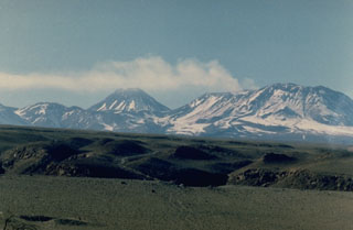
Eruptive activity [in September 1986] was observed by MINSAL Co. geologists in Toconao (32.5 km NW). Paul King, Sheila King, and John Heathcote reported that single explosive events occurred on 14, 15, and 16 September. Prior to the eruptions, a prominent steam plume, larger than the normal plume, had been present but no significant seismic activity had been recorded. No glow from the summit had been visible at night.
The 14 September eruption (at 1430) sent a brown, ash-laden cloud as much as several hundred meters above the crater rim. Ash pulses continued for ~30 minutes. After ~45 minutes all activity had ended. The 15 September eruption occurred at about the same time of day and appeared to be of similar magnitude, but visibility was poor. The explosive event of 16 September was powerful but brief, and ejected only a small amount of ash. It began with a loud, somewhat sustained, rumbling explosion at about 0730. A brown ash cloud rose vertically as a dense plug, expanded, took on a cauliflower texture, and finally broadened into a mushroom-shaped cloud extending SE. No pyroclastic flows were observed and the ash column dispersed rapidly. The first minutes of the eruption were photographed. Altitudes of ash clouds (measured from the photographs) reached at least 15 km altitude and the plume may have extended 20 km downwind. A GOES satellite image at 0800 showed a small plume stretching E from Lascar. By 0900 it had turned S but an hour later its distal end was obscured by clouds.
Field investigations on 1 April 1987 revealed no magmatic activity. Vapor from vents on the sides of a deep, steep-walled pit crater created a bluish haze but no white steam cloud was present. A strong SO2 smell was noted by geologists in an aircraft above the volcano. No incandescence was observed. An extremely thin layer of ash covered the SE flanks, concentrated along a very narrow axis of dispersion. At 0.5 km from the volcano the largest fresh tephra particles were 5-10-mm angular fragments of dense, dark, unvesiculated lava, very similar to the finer grained ash (0.01-0.02 mm diameter) that fell on Salta on 16 September.
Observations from aircraft showed a large number of impact craters and ejected blocks on the N flank. Most seemed to predate the 16 September eruption but a few appeared to geologists to be extremely fresh ('rays' of ejecta were well preserved). Fresh, dense, andesitic lava blocks in these craters were up to 40 cm in diameter.
The geologists found no evidence to suggest that juvenile material was erupted. Thermal studies with the Landsat T M during 1985 and 1986 had shown a thermal anomaly at Lascar that was much stronger than any other in the central Andes. Francis and Rothery (1987) interpreted the anomaly as indicating the presence of magma, or possibly a lava lake, in the summit crater complex.
Reference. Francis, P.W. and Rothery, D.A., 1987, Using the Landsat Thematic Mapper to Detect and Monitor Active Volcanoes: an Example from Northern Chile; Geology, v. 15, no. 7, p. 614-617.
Further Reference. Glaze, L.S., Francis, P.W., Self, S., and Rothery, D.A., 1989, The 16 September 1986 Eruption of Lascar Volcano, North Chile: Satellite Investigations; Bulletin of Volcanology, v. 51, p. 149-160.
Geological Summary. Láscar is the most active volcano of the northern Chilean Andes. The andesitic-to-dacitic stratovolcano contains six overlapping summit craters. Prominent lava flows descend its NW flanks. An older, higher stratovolcano 5 km E, Volcán Aguas Calientes, displays a well-developed summit crater and a probable Holocene lava flow near its summit (de Silva and Francis, 1991). Láscar consists of two major edifices; activity began at the eastern volcano and then shifted to the western cone. The largest eruption took place about 26,500 years ago, and following the eruption of the Tumbres scoria flow about 9000 years ago, activity shifted back to the eastern edifice, where three overlapping craters were formed. Frequent small-to-moderate explosive eruptions have been recorded since the mid-19th century, along with periodic larger eruptions that produced ashfall hundreds of kilometers away. The largest historical eruption took place in 1993, producing pyroclastic flows to 8.5 km NW of the summit and ashfall in Buenos Aires.
Information Contacts: P. Francis, Lunar and Planetary Institute, Houston; C. Ramirez, SERNAGEOMIN; W. Gould, NOAA/NESDIS.

