Report on Masaya (Nicaragua) — January 1988

Scientific Event Alert Network Bulletin, vol. 13, no. 1 (January 1988)
Managing Editor: Lindsay McClelland.
Masaya (Nicaragua) Vigorous degassing continues; small tephra eruptions and glow
Please cite this report as:
Global Volcanism Program, 1988. Report on Masaya (Nicaragua) (McClelland, L., ed.). Scientific Event Alert Network Bulletin, 13:1. Smithsonian Institution. https://doi.org/10.5479/si.GVP.SEAN198801-344100
Masaya
Nicaragua
11.9844°N, 86.1688°W; summit elev. 594 m
All times are local (unless otherwise noted)
When geologists visited the volcano on 25 December 1987 and 6 and 18 January 1988, two new, growing vents were visible (figure 5). The N vent was the hottest (table 1) and most active, emitting the majority of gases. By 18 January, the inner crater occupied half of Santiago's floor, while Santiago expanded westwards by collapse of the floor of neighboring Nindirí Crater. The NW side of Nindirí also seemed to be sagging along boundary faults. Gas output varied from vigorous (similar to 1985-86) to very little, perhaps because of periodic blockage of the two vents by landslides and rockfalls. One large gas burst was preceded by a loud roar and slightly raised temperatures.
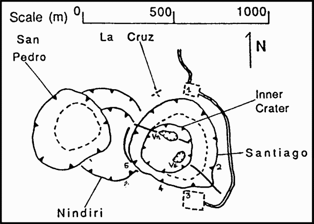 |
Figure 5. Sketch map of the craters of the Masaya complex as of 18 January 1988, showing the locations of temperature measurements in table 1. |
Table 1. Temperatures in Santiago Crater measured by infrared radiometer in late 1987 and early 1988. Surface brightness temperature was measured in the 8-14 µm range with emissivity set at 1. Locations of observation points are shown on figure 5.
| Date | 1 | 2 | 3(Vn) | 4(Vn) | 5 |
| 25 Dec 1987 | 35-40° | 54.6° | 66-125° | 100.5° | 80° |
| 06 Jan 1988 | 40° | -- | 110° | 121° | -- |
| 18 Jan 1988 | 36° | -- | 161° | 160° | -- |
Geological Summary. Masaya volcano in Nicaragua has erupted frequently since the time of the Spanish Conquistadors, when an active lava lake prompted attempts to extract the volcano's molten "gold" until it was found to be basalt rock upon cooling. It lies within the massive Pleistocene Las Sierras caldera and is itself a broad, 6 x 11 km basaltic caldera with steep-sided walls up to 300 m high. The caldera is filled on its NW end by more than a dozen vents that erupted along a circular, 4-km-diameter fracture system. The Nindirí and Masaya cones, the source of observed eruptions, were constructed at the southern end of the fracture system and contain multiple summit craters, including the currently active Santiago crater. A major basaltic Plinian tephra erupted from Masaya about 6,500 years ago. Recent lava flows cover much of the caldera floor and there is a lake at the far eastern end. A lava flow from the 1670 eruption overtopped the north caldera rim. Periods of long-term vigorous gas emission at roughly quarter-century intervals have caused health hazards and crop damage.
Information Contacts: B. van Wyk de Vries, H. Rymer, and G. Brown, Open Univ; P. Hradecky and H. Taleno, INETER.