Report on Nevado del Ruiz (Colombia) — March 1988

Scientific Event Alert Network Bulletin, vol. 13, no. 3 (March 1988)
Managing Editor: Lindsay McClelland.
Nevado del Ruiz (Colombia) Ash emission follows earthquake swarm
Please cite this report as:
Global Volcanism Program, 1988. Report on Nevado del Ruiz (Colombia) (McClelland, L., ed.). Scientific Event Alert Network Bulletin, 13:3. Smithsonian Institution. https://doi.org/10.5479/si.GVP.SEAN198803-351020
Nevado del Ruiz
Colombia
4.892°N, 75.324°W; summit elev. 5279 m
All times are local (unless otherwise noted)
February data are from the Boletín Informativo, published monthly by the Observatorio Vulcanológico de Colombia. The number of high-frequency events increased significantly in the second half of February, totaling 707 for the month, as compared to 280 in January (figure 7). Hypocenters, at 1-5 km depth, were clustered in three zones: near Nevado de Santa Isabel (~10 km SW of the active Arenas Crater) on 10 February; to the NE at Nevado del Cisne (~6 km SW of Arenas) on 21 February; and an especially active sequence at Arenas 12-22 February. Low-frequency events declined slightly to 1,362, from 1,540 the previous month, and did not parallel the late February increase in high-frequency shocks. A few more shallow earthquakes were recorded in February (74) than in January (65). Tremor remained at minimal amplitudes until the end of the month, when brief episodes of long-period (0.7-1 second) tremor reached maximum peak-to-peak amplitudes of 7 mm. The rate of SO2 emission measured by COSPEC ranged from ~1,000 to 3,000 t/d and averaged 1,843 t/d. Deformation changes, monitored by dry and electronic tilt and electronic distance measurements, appeared to be small.
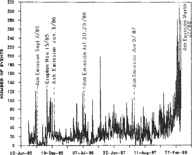 |
Figure 7. Daily number of recorded earthquakes at Ruiz, 20 July 1985-31 March 1988. Larger eruptive episodes are labeled. Courtesy of INGEOMINAS. |
Ash emission began on 22 March at 0935, the day after a long-period earthquake swarm. Activity briefly became more vigorous on 25 March before declining that night. Eruption column heights did not exceed 2-3 km and were usually <1 km. Ash fell to the NW, where 2 mm accumulated in Manizales (~30 km from the crater) and 15 mm were deposited closer to the volcano. No fresh magma was observed in the ash. Tremor increased rapidly 20 minutes after the onset of ash emission, remained at a high level for the next six days, then decreased slowly before reaching a minimum on 29 March. Civil Defense officials declared an orange alert and ordered the evacuation of the area within 10 km of the crater. Several hundred people left the hazard zone, but the press reported that at least 1,000 chose to remain. The warning was reduced to a yellow alert on 27 March, signaling that the activity was not imminently dangerous.
The number of recorded seismic events was 220% higher in March than in February. Most events were centered in two zones, one beneath the active Arenas crater (sometimes called Cumanday) and the other 3.5 km from the crater on the SW flank. Depths ranged from 0.15 to 5 km. Maximum daily seismic energy release was 124 x 106 ergs (figure 8). Rates of SO2 emission reached 7,700 t/d (figure 9), the highest measured since September 1986. The average daily rate in March was 2,800 t/d (figure 10) but values declined after ash emission began, a pattern similar to that associated with the June and October 1987 ash emissions. No significant changes were observed in deformation data.
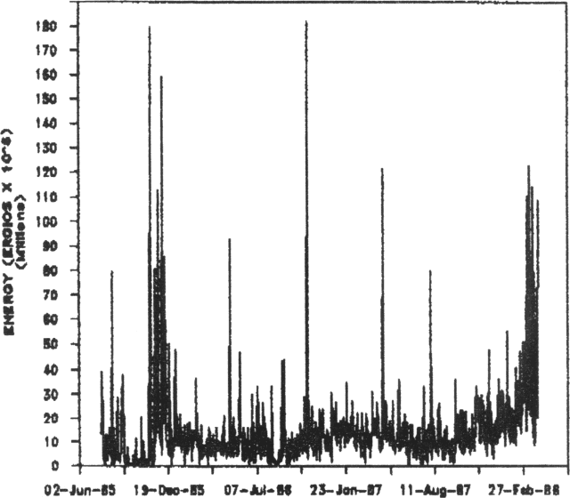 |
Figure 8. Seismic energy release at Ruiz, in 106 ergs, 20 July 1985-31 March 1988. Courtesy of INGEOMINAS. |
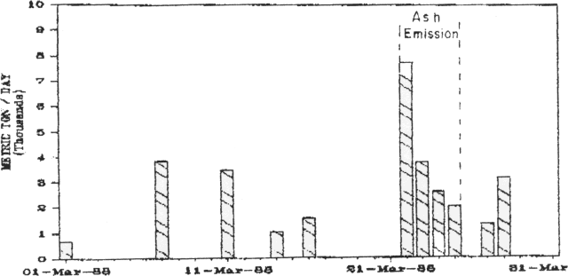 |
Figure 9. Daily SO2 flux at Ruiz, measured by COSPEC in March 1988. Dashed lines mark the 22-25 March ash emission. Courtesy of INGEOMINAS. |
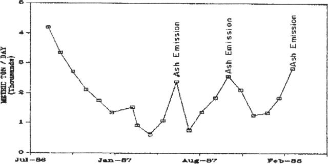 |
Figure 10. Average daily SO2 flux for each month, July 1986-March 1988. Courtesy of INGEOMINAS. |
Geological Summary. Nevado del Ruiz is a broad, glacier-covered volcano in central Colombia that covers more than 200 km2. Three major edifices, composed of andesitic and dacitic lavas and andesitic pyroclastics, have been constructed since the beginning of the Pleistocene. The modern cone consists of a broad cluster of lava domes built within the caldera of an older edifice. The 1-km-wide, 240-m-deep Arenas crater occupies the summit. The prominent La Olleta pyroclastic cone located on the SW flank may also have been active in historical time. Steep headwalls of massive landslides cut the flanks. Melting of its summit icecap during historical eruptions, which date back to the 16th century, has resulted in devastating lahars, including one in 1985 that was South America's deadliest eruption.
Information Contacts: R. Mendez, O. Bohorquez, A. Nieto, and M. Calvache, INGEOMINAS, Manizales; UPI; AP.