Report on Kilauea (United States) — May 1988

Scientific Event Alert Network Bulletin, vol. 13, no. 5 (May 1988)
Managing Editor: Lindsay McClelland.
Kilauea (United States) Lava destroys houses, re-enters ocean
Please cite this report as:
Global Volcanism Program, 1988. Report on Kilauea (United States) (McClelland, L., ed.). Scientific Event Alert Network Bulletin, 13:5. Smithsonian Institution. https://doi.org/10.5479/si.GVP.SEAN198805-332010
Kilauea
United States
19.421°N, 155.287°W; summit elev. 1222 m
All times are local (unless otherwise noted)
After the short hiatus at the end of April , lava quickly reoccupied the tube system to 480-500 m elevation, where outbreaks fed new surface flows. The new flows branched into two primary lobes and covered a broad area down to 360 m elevation. New tube systems were formed and lava moved rapidly down the steep scarp (pali) on 6 May. The W lobe followed earlier flows along the W edge of the lava field.
The E lobe advanced along the E edge of the lava field on top of pre-1983 flows, following the course of November 1986 lava. When 1,100 m from the coast on 11 May, the E lobe divided (figure 55). On the following day, the last house in the Kapaahu subdivision was destroyed . . . . By the 13th, the flow reached Hwy 130, covered another 200 m of the road, and destroyed another house on the ocean side of the road before reaching the sea the next day. Both houses had been occupied until just prior to the renewed activity. The other sublobe moved E into the forest, turned SE and filled an abandoned gravel quarry 500 m E of the previous flows, before crossing the highway on the 14th. The two eastern sublobes remained intermittently active for the rest of the month, one entering the ocean at times, and the other pooling near an old quarry. On 13 May the W lobe entered the ocean E of Kupapau point. During the second half of May, new lava was much more voluminous along the W front, probably accounting for > 2/3 of the total output.
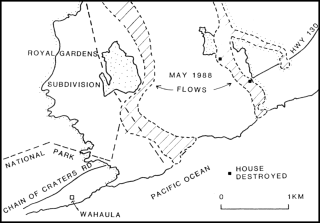 |
Figure 55. Sketch map of the S coast of Hawaii showing 1983-8 lava flows from Kīlauea (white), May 1988 flows (cross-ruled), and locations of destroyed houses. |
At Pu`u `O`o, heavy fume obscured the conduit for part of the month, but lava was observed moving W to E in a narrow channel at the bottom of the crater (roughly 160 m below the rim) the first week in May, and a helicopter pilot sighted active fountaining at the bottom of the crater on another occasion. Rockfalls from the crater walls covered the bottom of the crater with debris. Activity at the lava pond on Kupaianaha shield fluctuated from minor overflows at the beginning and end of the month to 10-20 m below the rim 10-23 May.
Harmonic tremor continued . . . near Pu`u `O`o and Kupaianaha. After several days of relatively steady tremor that gradually increased in amplitude during the late-April hiatus in lava production, the signature changed into a variable-amplitude pattern characteristic of vigorous lava movement within Pu`u `O`o vent at 0510 on 1 May. For most of the month the East-rift tremor varied from moderate to low amplitude at intervals ranging from minutes to days. Short tremor bursts alternating with long intervals of low-amplitude tremor characterized gas piston activity at Pu`u `O`o on some days. The number of shallow microearthquakes was generally low in the summit region and East rift zone. Several bursts of shallow and intermediate-depth long-period events and tremor occurred beneath the summit region. Earthquakes of M 1.5-3.0 persisted in the S flank of Kīlauea at depths of 5-10 km.
Geological Summary. Kilauea overlaps the E flank of the massive Mauna Loa shield volcano in the island of Hawaii. Eruptions are prominent in Polynesian legends; written documentation since 1820 records frequent summit and flank lava flow eruptions interspersed with periods of long-term lava lake activity at Halemaumau crater in the summit caldera until 1924. The 3 x 5 km caldera was formed in several stages about 1,500 years ago and during the 18th century; eruptions have also originated from the lengthy East and Southwest rift zones, which extend to the ocean in both directions. About 90% of the surface of the basaltic shield volcano is formed of lava flows less than about 1,100 years old; 70% of the surface is younger than 600 years. The long-term eruption from the East rift zone between 1983 and 2018 produced lava flows covering more than 100 km2, destroyed hundreds of houses, and added new coastline.
Information Contacts: C. Heliker and R. Koyanagi, HVO.