Report on Kie Besi (Indonesia) — July 1988
Scientific Event Alert Network Bulletin, vol. 13, no. 7 (July 1988)
Managing Editor: Lindsay McClelland.
Kie Besi (Indonesia) 100-year dormancy ends with large ash eruption; 15,000 evacuated; no fatalities
Please cite this report as:
Global Volcanism Program, 1988. Report on Kie Besi (Indonesia) (McClelland, L., ed.). Scientific Event Alert Network Bulletin, 13:7. Smithsonian Institution. https://doi.org/10.5479/si.GVP.SEAN198807-268070
Kie Besi
Indonesia
0.32°N, 127.4°E; summit elev. 1357 m
All times are local (unless otherwise noted)
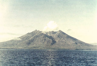
Makian emitted a white fume cloud 500 m above the summit crater on 17 July, ending a 100-year dormancy. Local residents reported a reddish glow at the cloud's base. The 15,000 residents of Makian Island were evacuated to Moti Island, 10 km N, in anticipation of a larger event similar to past violent eruptions. A NOTAM issued on 18 July at 1156 warned aircraft to avoid the area below ~2 km altitude. By 28 July, activity was limited to emission of a white fume cloud. On 29 July at 1115, a 7-km ash column was erupted, and at 1121, a larger explosion ejected an 8-km cloud. VSI monitored the eruption from its observation post on Moti Island. Smaller explosions occurred that afternoon and were continuing as of 1 August.
GMS satellite imagery first showed an eruption plume on 29 July [at] 1200, when a cloud 55 km wide and 100 km long extended SW from Makian (figure 1). Its coldest area was from -68 to -75°C, corresponding to an altitude of 14-16 km asl (figure 2). Plumes were not evident at 1800 or 2100. Small volcanic-like clouds, ~30 km wide and 130 km long, were seen from Makian to the WSW at 2100 on 30 July and 0300, 0900, 1200 on 31 July. Other small clouds seen 1-4 August may be atmospheric.
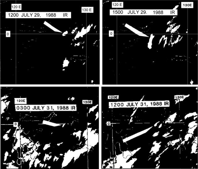 |
Figure 1. Portions of four infrared GMS satellite images on 29 and 31 July 1988, showing clouds that may have been erupted from Makian. Arrows indicate the clouds, apparently attached to the volcano at 1200 on 29 July and at 1200 on 31 July. Courtesy of Y. Sawada. |
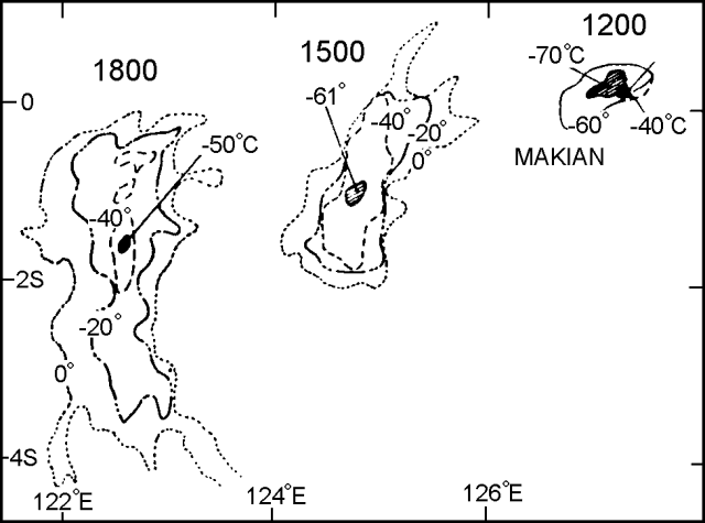 |
Figure 2. Temperature gradients in Makian's 29 July 1988 eruption cloud, measured from three GMS infrared images. The volcano is indicated by a solid triangle. Courtesy of Y. Sawada. |
Geological Summary. Kie Besi volcano, forming the 10-km-wide Makian island off the west coast of Halmahera, has been the source of infrequent, but strong eruptions that have devastated villages on the island. The large 1.5-km-wide summit crater, containing a small lake on the NE side, gives the peak a flat-topped profile. Two prominent valleys extend to the coast from the summit crater on the north and east sides. Four cones are found on the western flanks. Eruption have been recorded since about 1550; major eruptions in 1646, 1760-61, 1861-62, 1890, and 1988 caused extensive damage and many fatalities.
Information Contacts: VSI; J. Latter, DSIR Geophysics, New Zealand; Y. Sawada, JMA.