Report on Mayon (Philippines) — August 1988

Scientific Event Alert Network Bulletin, vol. 13, no. 8 (August 1988)
Managing Editor: Lindsay McClelland.
Mayon (Philippines) Lahars and faint crater glow
Please cite this report as:
Global Volcanism Program, 1988. Report on Mayon (Philippines) (McClelland, L., ed.). Scientific Event Alert Network Bulletin, 13:8. Smithsonian Institution. https://doi.org/10.5479/si.GVP.SEAN198808-273030
Mayon
Philippines
13.257°N, 123.685°E; summit elev. 2462 m
All times are local (unless otherwise noted)
Since late 1987, white emissions from Mayon have remained volumetrically moderate, obscuring 20-50% of the crater. Bluish fumes accompanying steam emission were first noted on 26 July and were also seen on 1, 2, and 9 August, moving downslope to the NE and E. On 19 July, there was one report of rumbling noises. A lahar on 14 August (at about 2100) moved SE down Basud, Matanag, and Mabinit gullies and was recorded on the Santa Misericordia Station (SMS) about 8 km E of the crater (figure 4). Field observations indicated that the lahar eroded 1.3 m of the Matanag gully near the Buyuan-Matanag road. Rainfall measured 56.0 mm at the SMS station.
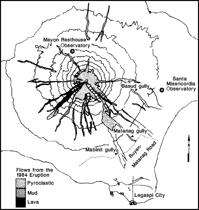 |
Figure 4. Map of Mayon showing gullies affected by the 14 August 1988 lahars and relative positions of seismograph stations. Modified from a PHIVOLCS hazard map, 1984 eruption. |
Faint crater glow was first seen during the night of 15 August from the SMS station and from Bogtong, Legaspi City (12 km SE of the crater). From 16 to 22 August, four high-frequency and 18 low-frequency events were registered by seismographs around the volcano. The water tube tiltmeter readings at the Mayon Resthouse Observatory (3.5 km N of the crater) have indicated an inflationary trend since March 1988.
Geological Summary. Symmetrical Mayon, which rises above the Albay Gulf NW of Legazpi City, is the most active volcano of the Philippines. The steep upper slopes are capped by a small summit crater. Recorded eruptions since 1616 CE range from Strombolian to basaltic Plinian, with cyclical activity beginning with basaltic eruptions, followed by longer periods of andesitic lava flows. Eruptions occur predominately from the central conduit and have also produced lava flows that travel far down the flanks. Pyroclastic density currents and mudflows have commonly swept down many of the approximately 40 ravines that radiate from the summit and have often damaged populated lowland areas. A violent eruption in 1814 killed more than 1,200 people and devastated several towns.
Information Contacts: PHIVOLCS.