Report on Pacaya (Guatemala) — November 1988

Scientific Event Alert Network Bulletin, vol. 13, no. 11 (November 1988)
Managing Editor: Lindsay McClelland.
Pacaya (Guatemala) Strombolian activity and lava flows
Please cite this report as:
Global Volcanism Program, 1988. Report on Pacaya (Guatemala) (McClelland, L., ed.). Scientific Event Alert Network Bulletin, 13:11. Smithsonian Institution. https://doi.org/10.5479/si.GVP.SEAN198811-342110
Pacaya
Guatemala
14.382°N, 90.601°W; summit elev. 2569 m
All times are local (unless otherwise noted)
Strombolian eruptions accompanied by lava extrusion continued at Pacaya during 1988. The SW flank lava flow observed in February remained active for about 2 months. In March and April lava extrusion began from new vents about 200-400 m below the summit. Lava effusion stopped in May, but resumed 26 May from new vents on the SW flank and continued into June, feeding flows that traveled about 1 km down the W, WSW, SW, SSW, and S flanks. Counts of explosions derived by Otoniel Matías from INSIVUMEH seismic records (figure 3) indicate that explosions increased from a few hundred/day in early June to about 2,000/day in mid-June. Ash fell 2.5 km from the volcano on 11 June. Explosions dropped to a few hundred/day in July and lava effusion stopped from all but one vent. Activity remained low in August, although a SW flank lava flow was emitted on 23 August. A lava flow formed on the NW flank at about 2330 on 6 September, and was active until 18-19 September. When the seismograph resumed operation in mid-September, daily explosion counts ranged from about 1,500 to 2,300. On 20 September a new lava flow began on the S flank at about 2,100 m altitude. Activity increased late September to early October, when some seismic events were felt on Cerro Chino (on the NW somma rim) and rumblings were heard in the S part of Guatemala City. A new lava flow was emitted 4-5 October from a vent at 2,070 m on the SW flank. The daily number of explosions peaked at 3,300 on 5 October, and gradually decreased after 10 October to fewer than 1,000 by 29 October, when lava emission ceased.
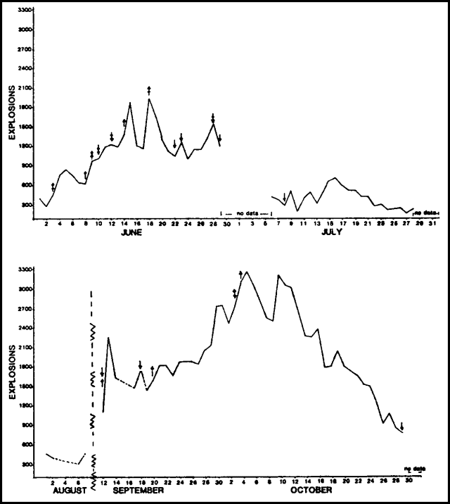 |
Figure 3. Estimated number of explosions/day at Pacaya, June-October 1988. Explosion events were counted on a vertical section of each day's seismic records from station PCG (on Cerro Chino, 1.5 km NW of MacKenney Crater) then extrapolated to yield 24-hour values. Upward-pointing arrows indicate the appearance of a new lava flow, downward arrows the cessation of feeding for a previously active flow; 2-headed arrows indicate the same observations but for two flows. Courtesy of Otoniel Matías. |
During fieldwork 12-26 November on the S side of Pacaya, geologists observed MacKenney Crater during another period of increased activity. On 20 November the active vent was seen from the summit of the 1775 cone. More or less continuous weak Strombolian explosions ejected bombs to a few tens of meters above the crater rim. These were punctuated several times a minute to every few minutes by detonations from stronger explosions that ejected incandescent bombs and blocks to 100-200 m height from a vent at the NW end of MacKenney Crater. Some incandescent blocks rolled 400 vertical meters down the flanks of the cone as far as the moat between MacKenney Crater and the N somma rim. Incandescent ejecta was sometimes visible in daylight from the somma rim in contrast to the less vigorous February activity, and daytime explosions could also be seen from Guatemala City, 25 km NNE.
An area of active fumaroles was located on the N flank about 100 m below the summit. The accumulation of near-vent ejecta in the absence of major explosions since February had considerably narrowed the crater's width and recently raised MacKenney cone to an altitude slightly above that of the 1775 cone, which had formed the highest point on Pacaya at 2552 m. A lava flow originated in early November from a vent high on the SW flank at about the elevation of the saddle between the two summit cones. Lava flowed in several channels to about 2,000 m altitude on the SW flank, and extrusion was continuing on 26 November.
Geological Summary. Eruptions from Pacaya are frequently visible from Guatemala City, the nation's capital. This complex basaltic volcano was constructed just outside the southern topographic rim of the 14 x 16 km Pleistocene Amatitlán caldera. A cluster of dacitic lava domes occupies the southern caldera floor. The post-caldera Pacaya massif includes the older Pacaya Viejo and Cerro Grande stratovolcanoes and the currently active Mackenney stratovolcano. Collapse of Pacaya Viejo between 600 and 1,500 years ago produced a debris-avalanche deposit that extends 25 km onto the Pacific coastal plain and left an arcuate scarp inside which the modern Pacaya volcano (Mackenney cone) grew. The NW-flank Cerro Chino crater was last active in the 19th century. During the past several decades, activity has consisted of frequent Strombolian eruptions with intermittent lava flow extrusion that has partially filled in the caldera moat and covered the flanks of Mackenney cone, punctuated by occasional larger explosive eruptions that partially destroy the summit.
Information Contacts: Otoniel Matías, Jorge Girón, and Enrique Molina, INSIVUMEH; Jim Vallance, Michigan Tech; Lee Siebert, SI.