Report on Poas (Costa Rica) — March 1989
Scientific Event Alert Network Bulletin, vol. 14, no. 3 (March 1989)
Managing Editor: Lindsay McClelland.
Poas (Costa Rica) Crater lake shrinks; gases cause illness and damage plants
Please cite this report as:
Global Volcanism Program, 1989. Report on Poas (Costa Rica) (McClelland, L., ed.). Scientific Event Alert Network Bulletin, 14:3. Smithsonian Institution. https://doi.org/10.5479/si.GVP.SEAN198903-345040
Poas
Costa Rica
10.2°N, 84.233°W; summit elev. 2697 m
All times are local (unless otherwise noted)
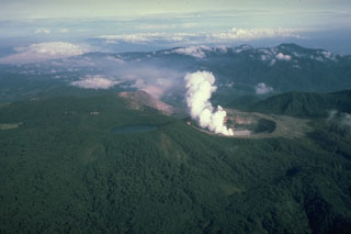
The level of the crater lake continued to descend, dropping another 2 m in March for a cumulative decline of about 32 m since early 1987 (figures 11 and 12). Phreatic (geyser-type) eruptions were sporadic and generally no more than 10 m high, although ejecta reached heights of 60 m on 12 February and 50 m on 2 April. Lake water was colored muddy gray by suspended sediment, and convective bubbling was continuous. At the beginning of March, movement of rafts of floating sediment illustrated convective trajectories within the lake. Rafts were not seen in the middle of the month, although there was some thick floating sediment. By the end of March, no floating material was evident. The temperature of the lake water averaged 82°C.
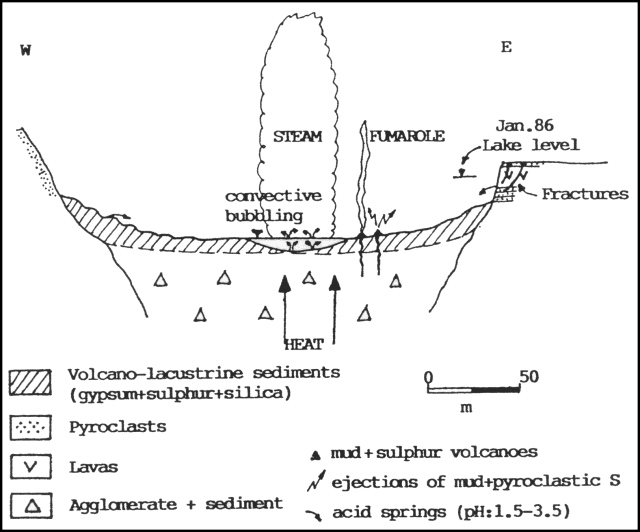 |
Figure 11. W-E diagrammatic cross-section of the crater at Poás illustrating March 1989 activity. Courtesy of Gerardo Soto. |
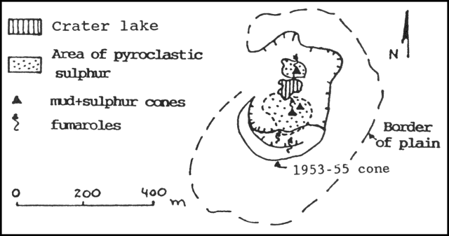 |
Figure 12. Sketch map of the crater at Poás in March 1989. Courtesy of Gerardo Soto. |
Small sulfur cones had formed on sedimentary terraces at the SE edge of the lake, constantly ejecting sprays of mud and pyroclastic sulfur that carpeted the surrounding area. Some had collapsed, forming craters that continuously emitted gas. The most active made a sound like a jet aircraft. Some of the cones were topped by chimney-like structures ~1 m high, made of sulfur. Two small sulfur cones had also developed on the lake's NE edge, venting gases with a mean temperature of 98°C.
Fumarolic activity on the 1953-55 [dome] was weak and located at the summit and N side, with temperatures varying between 59°C and 91°C. The temperature of fumaroles W of the [dome] was 95°C.
Prevailing winds carried volcanic gases W and SW of the crater, damaging vegetation and causing health problems for residents. Towns to 10 km SW of the crater (such as San Luis Cajón de Grecia) were impacted. Coffee has been the crop most affected, with preliminary calculations of losses reaching about $500,000. Trees (cypress, jaul, and eucalyptus) and grass were burned by acid rain. The inhabitants of towns as far as Trojas de Valverde Vega (11 km WSW of the crater) and San Pedro Poás (14 km SW) suffered health problems including eye and respiratory irritation and allergies. Consequently, local health facilities have had an increase in patients.
Since mid-January, a telemetering seismic station near the summit (POA2) has registered an average of 300 B-type events/day. Volcanic microseismicity declined in March compared to February, but remained higher than in 1988. Between 1 and 29 March, 6,726 events were recorded, an average of 232/day. The most active day was the 18th, when 346 shocks were detected (figure 13). Most were B-types, some with dispersive trains. Only three A-types were recorded during the month. Partial reoccupation of a level line indicated that 25 µrad of deflation had accumulated between October 1988 and March 1989. The horizontal distance across the crater did not show significant changes.
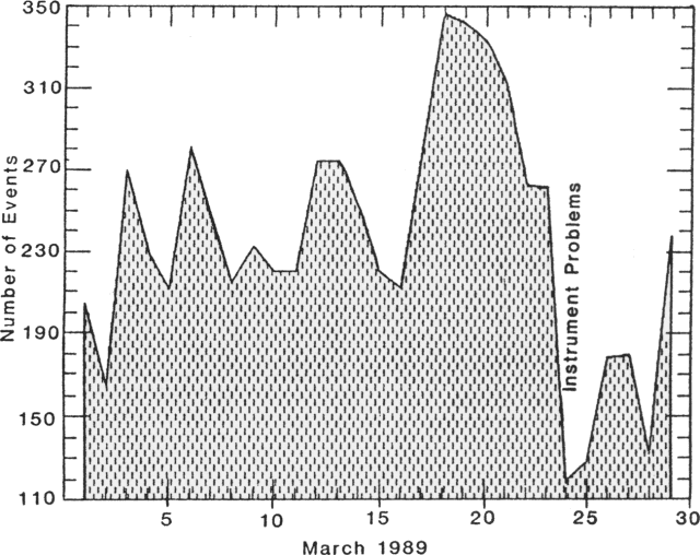 |
Figure 13. Number of local seismic events/day recorded by the Red Sismológica Nacional, March 1989. Courtesy of G. Soto. |
Geologists from the Univ de Costa Rica noted that the thermal activity formerly concentrated at the 1953-55 [dome] (between 1980 and 1987) has moved to the lake. They suggested two possible causes: (1) the fracture zone that controls thermal energy release has changed position; or (2) magma is rising below the lake, causing greater heat flow, and could lead to an eruptive event.
Geological Summary. The broad vegetated edifice of Poás, one of the most active volcanoes of Costa Rica, contains three craters along a N-S line. The frequently visited multi-hued summit crater lakes of the basaltic-to-dacitic volcano are easily accessible by vehicle from the nearby capital city of San José. A N-S-trending fissure cutting the complex stratovolcano extends to the lower N flank, where it has produced the Congo stratovolcano and several lake-filled maars. The southernmost of the two summit crater lakes, Botos, last erupted about 7,500 years ago. The more prominent geothermally heated northern lake, Laguna Caliente, is one of the world's most acidic natural lakes, with a pH of near zero. It has been the site of frequent phreatic and phreatomagmatic eruptions since an eruption was reported in 1828. Eruptions often include geyser-like ejections of crater-lake water.
Information Contacts: J. Barquero, OVSICORI; G. Soto, Mario Fernández, and Héctor Flores, UCR.