Report on Ambrym (Vanuatu) — April 1989
Scientific Event Alert Network Bulletin, vol. 14, no. 4 (April 1989)
Managing Editor: Lindsay McClelland.
Ambrym (Vanuatu) Ash plume and lava flow; recent eruption history
Please cite this report as:
Global Volcanism Program, 1989. Report on Ambrym (Vanuatu) (McClelland, L., ed.). Scientific Event Alert Network Bulletin, 14:4. Smithsonian Institution. https://doi.org/10.5479/si.GVP.SEAN198904-257040
Ambrym
Vanuatu
16.25°S, 168.12°E; summit elev. 1334 m
All times are local (unless otherwise noted)
On 31 April at 0730, the meteorological service in Wellington, New Zealand detected volcanic ash clouds near 16.1°S, 168.1°E on satellite images. The main cloud had an estimated diameter of 15-30 km, with streamers to 115 km NNE, and moved at a speed of ~30 km/hour. The plume height was estimated at ~6 km from an aircraft at 0350. The meteorological service in Darwin, Australia also located a steam/ash cloud on visible satellite images at 1030. NOAA infrared and visible images showed only a small cloud on 31 April at 1344 during clear weather. The following is a report from J.P. Eissen, M. Lardy, M. Monzier, L. Mollard, and D. Charley of ORSTOM (Nouméa and Port Vila).
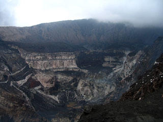
Description and history. "Ambrym, a large stratovolcano with a 15-km-wide caldera (figure 1), is one of the most active volcanoes of the New Hebrides arc, which includes Yasur (Tanna Island), Lopevi (Lopevi Island), and the shallow submarine volcano Karua (between Epi and Tongoa Islands).
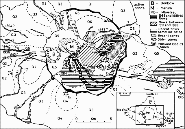 |
Figure 1. Geologic features of Ambrym caldera. The 1988 and 1989 lava flow paths have been modified after Monzier and Douglas (1989). Q1 = Tuvio volcanics (old northern Ambrym volcano), Q2 = older flank volcanics, Q3 = younger flank volcanics, Q4 = Tower Peak volcanics, Q5 = undifferentiated recent caldera and flank volcanics, Q6 = NE and E Marum basaltic flows and related old cones. The area shown is outlined on the index map (inset) of the main topographic features of Ambrym Island. B = Benbow, M = Marum (active cones), To = Tower Peak, Tu = Mt. Tuvio (old volcanic centers), E = Endu village, O = Otas village, S = Sevisi village. Maps modified after geological (New Hebrides Geological Survey, 1976) and pedomorphological (Quantin, 1978) maps. |
". . . . In the historical period, at least five types of activity can be distinguished. From the most to least frequent, these are: 1) intra-caldera, intermittent, Strombolian-type activity with mild extra-caldera ashfalls, but without lava flows (occurs almost every year); 2) intracaldera eruption frequently preceded by lava lake formation in the crater — generally starts with emission of a Plinian column that produces extra-caldera ashfalls, followed by intra-caldera lava flows; 3) activity similar to (2) followed by lava overflowing from the caldera (1863 (?), 1913-14, 1942 eruptions); 4) extra-caldera lava emission from fissures (1894, 1913, 1929, 1936 eruptions) — sometimes evolves toward 5) formation of pyroclastic cones, sometimes accompanied by lava flows (1888, 1915, 1929 eruptions). Several of these types of actvity have occurred consecutively in the different phases of a single eruption (as in 1913-14 and 1929, the two major Ambrym eruptions).
"On 13 November 1986, an aircraft pilot reported an increase in activity at the volcano. Ash emission became significant 17 November, but activity decreased 19-20 November. A new cone formed (Cheney, 1986) 3 km E of the active Marum cone (figure 1) and produced an intra-caldera lava flow ~4 km long (Melchior, 1988).
May 1988 activity. "On 27 May 1988, a lava lake ~50 m in diameter was observed in Mbwelesu's crater. Benbow was emitting white clouds whereas Marum and Mbwelesu were emitting dark grey clouds (Melchior, 1988). On 10 August, intracaldera lava flowed S more than 1.5 km from what appeared to be a new cone, but was possibly an extension of Mbwelesu (Cheney, 1988). The flow (still warm) extended ~5 km S (Charley, 1988). This eruption had ended by 23 August.
April 1989 activity. "At 1000 on 24 April 1989, a pilot observed a large plume rising ~3,500 m above the volcano. A lava flow from the the 1988 cone was following the same path as the 1988 flow but was a few kilometers longer. It followed the creek near Endou village (figure 1) and may or may not have extended outside the caldera [but see 14:10]. About 1 km2 of Otas village was reported to be burned. On the night of 29 April, large areas of red glow were seen from boats cruising in the area, and winds carried ash NW. Young vegetation on the S flank was burned (possibly by acid rain), and rain water had a strong taste. Local inhabitants said that the eruption was normal for the volcano even though there were more loud roaring noises and small earthquakes than in 1986 or 1988. A local pilots' strike prevented further observation of the eruption, but on 10 May the volcano was still active." The eruption apparently stopped sometime before 14 May.
References. Charley, D., 1988, Rapport de Mission à Ambrym en Aout 1988: Document ORSTOM, Port Vila, 5 p.
Cheney, C.S., 1986, New volcanic eruption near Endu, SE Ambrym: Geology Dept Memo, 24 November 1986, 1 p.
Cheney, C.S., 1988, Volcanic activity report, Ambrym and Epi: Geology Dept Memo, 17 August 1988, 1 p.
Melchior, A.H., 1988, Rapport de Mission de Reconnaissance Volcanologique Ambrym (25-28 May 1988) et à Tanna (14 May 1988): Document ORSTOM, Nouméa, 10 p.
Quantin, P., 1978, Archipel des Nouvelles-Hébrides: Atlas des Sols et de quelques Données du Milieu: Cartes Pédologiques, des Formes du Relief, Géologiques et de la Végétation; ORSTOM (18 sheets).
Stephenson, P.J., McCall, G.J.H., Le Maitre, R.W., and Robinson, G.P., 1968, The Ambrym Island Research Project, in Warden, A.J., ed., New Hebrides Geological Survey Annual Report 1966: Port Vila, p. 9-15.
Geological Summary. Ambrym, a large basaltic volcano with a 12-km-wide caldera, is one of the most active volcanoes of the New Hebrides Arc. A thick, almost exclusively pyroclastic sequence, initially dacitic then basaltic, overlies lava flows of a pre-caldera shield volcano. The caldera was formed during a major Plinian eruption with dacitic pyroclastic flows about 1,900 years ago. Post-caldera eruptions, primarily from Marum and Benbow cones, have partially filled the caldera floor and produced lava flows that ponded on the floor or overflowed through gaps in the caldera rim. Post-caldera eruptions have also formed a series of scoria cones and maars along a fissure system oriented ENE-WSW. Eruptions have apparently occurred almost yearly during historical time from cones within the caldera or from flank vents. However, from 1850 to 1950, reporting was mostly limited to extra-caldera eruptions that would have affected local populations.
Information Contacts: J. Eissen, M. Lardy, M. Monzier, ORSTOM, New Caledonia; L. Mollard, and D. Chaney, ORSTOM, Vanuatu; J. Latter, DSIR Geophysics, Wellington; S. Kusselson, SAB; J. Temakon, Dept of Geology, Mines, and Rural Water Supply, Port Vila.