Report on Kilauea (United States) — June 1989

Scientific Event Alert Network Bulletin, vol. 14, no. 6 (June 1989)
Managing Editor: Lindsay McClelland.
Kilauea (United States) Earthquake causes bench collapse; no effect on eruption
Please cite this report as:
Global Volcanism Program, 1989. Report on Kilauea (United States) (McClelland, L., ed.). Scientific Event Alert Network Bulletin, 14:6. Smithsonian Institution. https://doi.org/10.5479/si.GVP.SEAN198906-332010
Kilauea
United States
19.421°N, 155.287°W; summit elev. 1222 m
All times are local (unless otherwise noted)
A M 6.1 S-flank earthquake on 25 June triggered collapse of the coastal lava bench, but apparently had little effect on the continuing eruption. Lava flows that emerged from the tube system on the lower flanks reached the sea at two new sites, after destroying structures near the coast.
Surface lava flows that broke from the W tube system in April and destroyed houses . . . in May advanced S towards the coast in June. Lower elevation lava breakouts from the W tube, which had moved SW around the Royal Gardens kipuka in May, also continued to advance. Lava flows moving W along the Chain of Craters road destroyed a maintenance area on 21 June. The two flow fronts merged the next day, destroying the National Park Service Wahaula Visitor Center (figure 61). By 25 June, the flow front had advanced another 100 m W along Chain of Craters road. A lava front that had moved to within 30 m of the coast in mid-May, stagnated, reactivated in mid-June, and entered the sea on 22 June in a new area at Kupapau Point. The Kupapau flow (intermittently active) had stagnated by 30 June, but resumed activity in early July. On 23 June, lava began entering the ocean at Poupou (just E of the Wahaula residential area). Lava also continued to enter the ocean E of Kupapau Point.
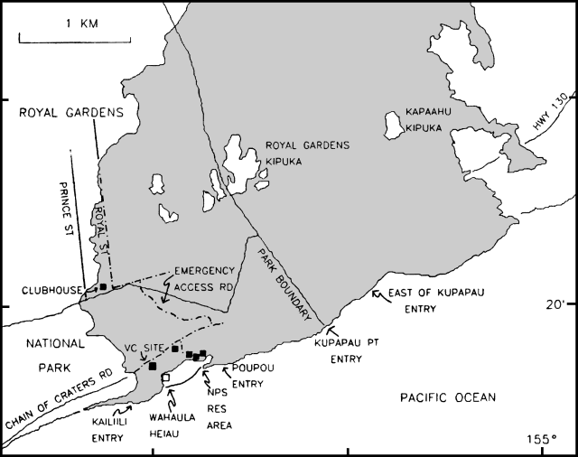 |
Figure 61. Map of the coastal area affected by the recent activity of Kupaianaha, as of September 1989. Dashed lines indicate roads buried in June and July; filled squares represent structures destroyed during the same period (VC = Visitor Center). Lava contacts from lower Royal Gardens subdivision to the Wahaula area are preliminary. The four "entries" are places where the lava was entering the ocean in July. Lava contacts from lower Royal Gardens subdivision to the Wahaula area are preliminary. Courtesy of Christina Heliker. |
The M 6.1 earthquake on 25 June at 1727 was centered on the SE coast, W of Kalapana, at 19.36°N, 155.08°W, 9 km depth (figure 62). Preliminary assessment of the data suggests that the main shock caused seaward movement of Kīlauea's S flank along a subhorizontal plane at the bottom of the volcanic pile near the ocean floor. Aftershock focal depths indicate rupture from near the surface to slightly more than 10 km depth. The motion was similar to the M 7.2 earthquake that struck the same region on 29 November 1975 and most of the strong S flank earthquakes (M>5.5) commonly occur in the mainshock area. Significant earthquakes also were located in this area in March 1954 and September 1979.
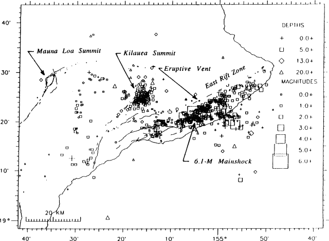 |
Figure 62. Locations of the M 6.1 earthquake and associated aftershocks, 25 June-6 July, 1989. Courtesy of R. Koyanagi. |
The earthquake caused almost total collapse of the seacoast lava bench, but apparently did not significantly disrupt the lava tube system. The next morning, geologists noted that the level of the Kupaianaha lava pond had dropped by ~1 m. Lava flow activity at the coast declined 27-28 June, accompanied by a slight decrease in tremor 26-28 June. On the 28th, tremor near the vent gradually rose to normal as the level of Kupaianaha lava pond rose ~1.5 m. By the next day, activity at the coast returned to the pre-earthquake level. An active lava pond in Pu`u `O`o was visible on 28 June.
During the last few days of June, tremor amplitude was relatively steady beneath the East rift zone near Pu`u `O`o and Kupaianaha. Low-amplitude tremor signals associated with ocean front activity near Kupapau Point also resumed. The 25 June earthquake saturated seismographs, masking signals from the associated lava bench collapse. The number of shallow microearthquakes was about average in the summit region and above average in the East rift zone. Intermediate-depth long-period events in the summit region continued at a moderate rate . . . .
Geological Summary. Kilauea overlaps the E flank of the massive Mauna Loa shield volcano in the island of Hawaii. Eruptions are prominent in Polynesian legends; written documentation since 1820 records frequent summit and flank lava flow eruptions interspersed with periods of long-term lava lake activity at Halemaumau crater in the summit caldera until 1924. The 3 x 5 km caldera was formed in several stages about 1,500 years ago and during the 18th century; eruptions have also originated from the lengthy East and Southwest rift zones, which extend to the ocean in both directions. About 90% of the surface of the basaltic shield volcano is formed of lava flows less than about 1,100 years old; 70% of the surface is younger than 600 years. The long-term eruption from the East rift zone between 1983 and 2018 produced lava flows covering more than 100 km2, destroyed hundreds of houses, and added new coastline.
Information Contacts: C. Heliker and R. Koyanagi, HVO.