Report on Poas (Costa Rica) — June 1989
Scientific Event Alert Network Bulletin, vol. 14, no. 6 (June 1989)
Managing Editor: Lindsay McClelland.
Poas (Costa Rica) Rains partly refill crater lake; intense gas emission
Please cite this report as:
Global Volcanism Program, 1989. Report on Poas (Costa Rica) (McClelland, L., ed.). Scientific Event Alert Network Bulletin, 14:6. Smithsonian Institution. https://doi.org/10.5479/si.GVP.SEAN198906-345040
Poas
Costa Rica
10.2°N, 84.233°W; summit elev. 2697 m
All times are local (unless otherwise noted)
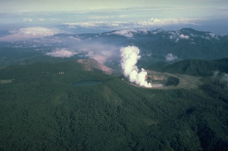
During the first 12 days of May, activity remained similar to that at the end of April. Gas emission was intense, and ejections of mud and lithic ash fed plumes that reached maximum heights of 1.5-2 km above the crater floor. Individual ash ejections lasted for more than an hour. Trade winds generally carried ash clouds toward the WSW. Various towns reported ashfalls, including Atenas, 32 km SW (on 9 May). Some ashfalls also occurred on the ENE and S flanks. On the rim, roughly 300 m W of the center of the crater (point F on figure 18) 5 mm of new ash was measured on 7 May and 60 mm on the 12th. The ash was composed of hydrothermally altered lithic fragments, soluble mud, and sulfur. The maximum measured grain size was 1.5 mm, and 80% of the ash volume was composed of fragments between 0.075 and 0.25 mm.
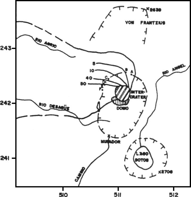 |
Figure 18. Sketch map of Poás showing ash isopachs as of 12 May. Grid spacing is 1 km. Thicknesses of ash at each collection point: A, 3 mm; B, 5 mm; C, 13-20 mm; D, 42 mm; E, 50 mm; F, 60 mm. Courtesy of Gerardo Soto. |
Gases were dominated by water vapor from the aquifer beneath the crater, and included SO2, H2S, and (possibly) hydrogen. Sulfur sublimates were deposited around fumarolic vents, and some of the sulfur burned, forming SO2. Flames from the combustion of sulfur (and perhaps hydrogen) were intense above some vents. In the center of the area formerly occupied by the crater lake, two primary pyroclastic mud cones (and various smaller neighboring cones) had been growing since mid-April, reaching maximum heights of 25 m despite frequent collapses. In the SE part of the crater, there was a molten, bubbling, sulfur lake and sulfur had flowed across the muddy crater floor. Fumaroles emitted sulfurous gases and a mud-sulfur cone was growing. The crater's NE quadrant included a vigorous fumarole that emitted sulfur-rich gas with a jet-aircraft sound, and deposited sulfur sublimates.
With the onset of the rainy season in mid-May, water started to accumulate in the former crater lake, reaching a depth of about 2 m by early June. Eruptive activity began to decline noticeably on 13 May. By the last week of May, the central cones had collapsed and been reworked by convective bubbling. Nevertheless, emission of water vapor and sulfur gases, some burning, continued at the end of the month. Bubbling was vigorous in the muddy zones on the crater floor, but no mud columns were ejected nor were there ash eruptions. The former site of the sulfur lake was occupied by a muddy area and a fumarole producing sulfur sublimates that burned with red-orange flames. Bubbling mud and intense evaporation were found in the active zone in the NE part of the crater. A zone of weak fumaroles and sulfur sublimates was present on the wall and NE side of the inner crater. Activity on the remnants of the 1953-55 [dome] remained stable through June, with low-temperature fumaroles depositing sulfur, gypsum, other minerals, and clays.
Intense gas emission (dominated by water vapor, with SO2 and H2S) continued in June from the crater lake. The lake remained about 2 m deep through the month. Its inner zone was muddy and showed continuous convective bubbling, while its periphery was emerald green with a pH <= 0.5, fed by multiple surface springs of about pH 2.0. There were five principal hot areas in the lake's inner zone, three in the N area, one in the center, and one to the SE. The NE site showed intense fumarolic activity and had constructed a small mud-sulfur cone that contained an orange-brown lake of molten sulfur and boiling mud. The central N site included small cones with mud/sulfur spines. Fumarolic activity and a mud rampart had developed at the SE site. At the other hot areas, intense convection of muddy water generated waves. Small emissions of muddy ash occurred within the crater, including one on 23 June at 1845 that produced a column hundreds of meters high. Other explosions occurred between 28 June and 2 July.
Substantial changes have been noted in volcanic seismicity. The characteristic B-type shallow (<500 m depth) signals declined in May but increased again in June.
During the first 30 days of May, 2,247 seismic events were recorded, a daily mean of about 75 (figure 19), down from 141/day in April. June's average was similar (1,904 events in the first 27 days, a mean of 71/day) but the number of earthquakes increased sharply after lower activity during the month's first week. Geologists noted that tremor or volcanic noise has become common at Poás, probably resulting from continuous degassing in a partially open conduit. Origins looked like those of B-type signals and the activity could represent continuous trains of B-type events. A-type shocks, of volcano-tectonic origin, had preliminary locations near the crater, with magnitudes <1.
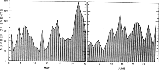 |
Figure 19. Number of seismic events/day at Poás, 1-30 May and 1-27 June, 1989. Courtesy of Mario Fernández. |
Geological Summary. The broad vegetated edifice of Poás, one of the most active volcanoes of Costa Rica, contains three craters along a N-S line. The frequently visited multi-hued summit crater lakes of the basaltic-to-dacitic volcano are easily accessible by vehicle from the nearby capital city of San José. A N-S-trending fissure cutting the complex stratovolcano extends to the lower N flank, where it has produced the Congo stratovolcano and several lake-filled maars. The southernmost of the two summit crater lakes, Botos, last erupted about 7,500 years ago. The more prominent geothermally heated northern lake, Laguna Caliente, is one of the world's most acidic natural lakes, with a pH of near zero. It has been the site of frequent phreatic and phreatomagmatic eruptions since an eruption was reported in 1828. Eruptions often include geyser-like ejections of crater-lake water.
Information Contacts: Gerardo J. Soto, Guillermo E. Alvarado, Mario Fernández, and Héctor Flores, UCR.